

Surveying & Construction
Learn how drones support surveying, mapping, progress tracking and site inspection across construction, engineering and infrastructure projects.
Surveying & Construction

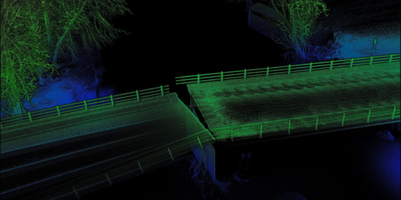
Survey accuracy starts before the dataset, with pilot competence
Survey accuracy does not start in the processing software. It starts with the pilot making competent decisions on site. Drones have become part of modern surveying, construction progress monitoring, mapping and site inspection. The commercial argument is well understood: faster data capture, less site disruption, safer access and better visibility. But professional drone surveying depends […]

Top 5 Multispectral Drones in 2026
Multispectral drones have surged in popularity as businesses and researchers uncover the vast potential of data collection offered by these cameras, capturing invaluable details that are invisible to the naked eye. These advanced systems capture data across multiple light spectrums, unveiling details of in water and on land that can’t be seen with the naked […]
What Does LiDAR Stand For? Everything You Need To Know About Light Detection And Ranging
In recent years, LiDAR technology has emerged as a powerful tool across various industries, revolutionising everything from surveying and mapping to autonomous vehicles and environmental monitoring. But what exactly is LiDAR, and how does it work? This blog dives deep into the world of LiDAR, explaining its underlying principles, different types, and applications, and why […]
How Much Does a Drone Cost? A Full Cost Breakdown 2024
Drones have become an integral part of both personal and professional landscapes, offering unparalleled opportunities in photography, surveying, agriculture, and more. As their popularity grows, so does the variety of options available, each with its own price point and set of features. Understanding the costs associated with different types of drones is crucial for potential […]

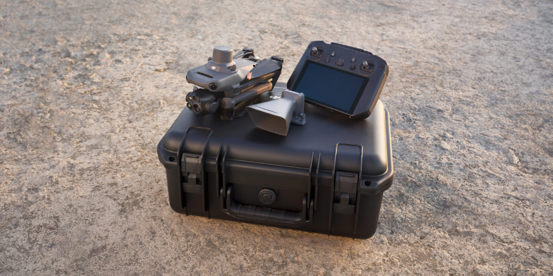
The DJI Enterprise Drone Buyer’s Guide
Whether you’re a CEO or a manager, this guide is the perfect starting point to explore the benefits of DJI’s Enterprise range of drones. By leveraging drone technology, you can enhance precision, increase efficiency, and make informed decisions that drive your business forward. Dive into our expert insights, practical applications, and in-depth analysis to discover […]
Get precise 3D scans from your mobile with Pix4Dcatch 2.0
We’re thrilled to spotlight the latest update of a leading-edge tool that transforms professional environments—PIX4Dcatch 2.0. This free app now comes packed with new AR features and RTK support for precision in surveying and construction. What Sets PIX4Dcatch 2.0 Apart? With the app, professionals can easily overlay AR georeferenced DXF, IFC, or 3D models directly […]

Everything you NEED to know about the DJI Dock 2
The anticipated DJI Dock 2 has launched, promising a design that is both lighter and more powerful than before. This year has seen significant advances in autonomous flying technology. Plans from the government show that by 2027, the UK plans to widely use Beyond Visual Line of Sight for drone operations. Drone docks or drone […]

Top 5 Drone Mapping Software for 2024
Drone mapping is an indispensable tool in today’s fast-paced, technologically advanced world. It has changed workflows across numerous industries, from agriculture and real estate to construction and environmental conservation. By providing a quick, efficient, and safe means to collect massive amounts of data, drone mapping allows for detailed analysis and insights that were previously impossible […]

Is the DJI Mavic 3 Enterprise Accurate for Surveying Work?
The DJI Mavic 3 Enterprise is a top contender for surveying work, blending precision, efficiency, and versatility into a budget-friendly package perfect for first-time and seasoned professionals alike. This drone offers various features designed to facilitate a wide range of surveying tasks, making it an invaluable tool in the arsenal of surveyors across various industries. […]

6 Ways to Improve Accuracy In Your Drone Surveys
Accuracy is the bedrock upon which every decision and design is built. There is nothing more frustrating than completing a survey and realising during post-processing that the data missed the mark a few times. Fortunately, multiple methods are at your disposal to manage factors that may impede the precision of your projects, including the best-kept […]

How to Process Data in Pix4Dcloud
In the ever-evolving landscape of drone data capture, the ability to swiftly and accurately process data can significantly enhance operational efficiency, reduce risk, and ensure the seamless cooperation between departments. For professionals navigating this complex terrain, Pix4Dcloud emerges as a beacon of innovation, offering a streamlined solution for processing and analysing drone-captured data. This article […]

DJI Modify Tutorial: How To Use DJI’s 3D Model Editing Software
The launch of DJI Modify marks a significant milestone in the world of drone technology and 3D modelling. This highly anticipated release, especially with its offer of a free 6-month public beta license, has created a buzz among enthusiasts and professionals alike who are eager to explore the capabilities of this new software. DJI Modify […]


Latest From Coptrz
Survey accuracy starts before the dataset, with pilot competence

Inspection work fails commercially when pilot competence is treated lightly

DJI Matrice 400

