

Government Body
Drones are increasingly used by government bodies to enhance operational efficiency, improve public safety, and support various civic functions. Their advanced capabilities provide invaluable tools for urban planning, environmental monitoring, disaster management, law enforcement, and infrastructure inspection.
- Increased Safety
- Higher Efficiency
- Cost-Effective
Get your FREE guide
Drones are increasingly used by government bodies to enhance operational efficiency.

For Educated And Efficient Decisions

Higher Efficiency
Drones offer real-time aerial views of emergency scenes, enabling first responders to quickly and accurately assess situations. Equipped with high-resolution cameras and thermal imaging, they provide critical information for informed decision-making. Additionally, drones can livestream feeds to multiple team devices, ensuring coordinated and effective response efforts.

Reduced Operational Cost
Drones offer a cost-effective alternative to traditional methods by reducing the need for expensive equipment and extensive manpower. They streamline operations, allowing government bodies to maximise their resources and achieve more within limited budgets. By cutting costs on manual labour, aerial surveys, and infrastructure inspections, drones enhance overall operational capabilities and efficiency.

Improved Safety
Enhancing safety in government operations, drones avoid risky tasks such as working at heights for inspections and risk assessments. They provide critical context in dangerous situations, such as monitoring unauthorised activities or environmental hazards, allowing response teams to come prepared.

Data Insights
Drones provide detailed data, including photogrammetry, LiDAR, thermal, and multispectral information. One drone flight produces thousands of measurements, which can be represented in different formats (orthomosaic, point cloud, 3D mesh, DTM, DSM, contour lines, etc). This allows for comprehensive analysis and accurate measurements for inspections, housing development, and environmental monitoring.
Cutting Edge Technology

Mission Live Streaming
Connect multiple devices to the drone live feed simultaneously, and keep teams updated across the site. Synchronise important information such as team positions, drone status, mission details, and more in real-time across various devices, for easy team collaboration during rescue missions or events.
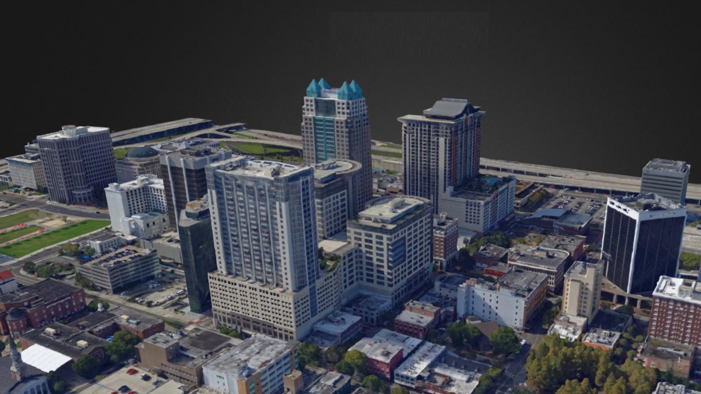
3D Modelling
Drones create detailed 3D models of construction sites and infrastructure, allowing for comprehensive analysis from a computer. Users can pan, rotate, and zoom in on models to scrutinise details and plan projects accurately.

Analysis And Annotation
Surveys can be tagged and annotated, classified by criticality. Measurement tools ensure accurate calculations for volume, mass, and dimensions for buildings and stockpiles, essential for project planning and management.

Urban Planning
Drones capture high-resolution aerial imagery and topographical data, assisting in urban planning and development. They create scaled maps and 2D and 3D models of cityscapes, helping planners make informed decisions on zoning, land use, and infrastructure development.
Environmental Monitoring
Drones monitor environmental conditions such as air and water quality, deforestation, and wildlife habitats. Multispectral drone sensors detect light reflections from plants and vegetation, revealing forest and water health. This technology identifies pollution sources, changes in water temperature, and pollutant levels that are invisible to the naked eye. These insights help government bodies take timely action to protect natural resources and ensure sustainable management.


Disaster Response
After natural disasters, drones quickly survey affected areas to assess damage, locate survivors, and identify hazards for effective resource deployment and rescue efforts. Process drone imagery into accurate, to-scale orthomosaic maps or 3D digital twins of areas, floodplains, and buildings. These can be analysed to support national and local decision-making, enhancing emergency preparedness planning before disaster strikes.
Law Enforcement
Drones assist law enforcement in surveillance, crowd control, and crime scene analysis. Outpace conventional vehicles, drones can arrive at emergency scenes within minutes, and cover land 86% faster than ground teams. By offering rapid overhead views, they enhance coordination, tactical planning, and foresight. Equipped with thermal imaging, drones can detect suspects hiding in foliage, tall grass, or darkness. Live feeds provide real-time video, enabling officers to share information and make quicker, more informed decisions with safety in mind.


Infrastructure Inspection
Drones equipped with high-resolution cameras and thermal sensors are invaluable for inspecting government infrastructure such as bridges, buildings, and pipelines. High quality visual, zoom, and thermal cameras on drones identify structural issues, heat loss, and other anomalies, enabling timely maintenance and repairs. Additionally, drones can create digital twins of assets, allowing for detailed office inspections. These digital twins are shareable across teams and easy to store for year-over-year comparisons for long-term asset management.
Event Management
For organising and overseeing large-scale events, drones offer real-time analytics that are invaluable for planning and security. They can map event sites, monitor crowd distribution, and provide security surveillance, all while capturing memorable moments from unique angles. This comprehensive approach ensures efficient event management and enhances the overall experience for attendees.


Housing Development
Drones provide detailed surveys of construction sites, capturing high-resolution images and topographical data. They produce orthomosaics and scaled 3D models, helping efficiently plan and execute housing projects, accelerating development timelines and improving project outcomes. Using pre-programmed flight paths and autonomous flight capabilities, drones can consistently collect precise aerial data from the same positions, ensuring accurate tracking of construction progress. This real-time monitoring helps identify delays, assess work quality, and make informed decisions to keep projects on track.
FAQs
Drones can capture high-resolution images, videos, thermal data, LiDAR scans, and topographical data, providing detailed and accurate information for planning, monitoring, and inspections.
Drones perform tasks that would otherwise require workers to enter hazardous areas, reducing the risk of accidents and injuries. They eliminate the need for manual inspections at heights or in dangerous environments.
Drones reduce labour costs, minimise the need for expensive equipment like scaffolding and cranes, and shorten survey and inspection times. This leads to significant savings in operational expenses and project budgets.
Drones equipped with advanced sensors like LiDAR and high-resolution cameras provide highly accurate measurements, essential for detailed surveys, volume calculations, and structural assessments.
Yes, drones can capture real-time images and data, allowing project managers to monitor progress, identify delays, assess work quality, and make informed decisions to keep projects on schedule.
Software such as DJI Terra, Pix4D, and similar platforms are used to process drone data. These tools generate orthomosaics, 3D models, and volumetric calculations, and facilitate data analysis and reporting.
Drones create accurate site surveys and maps using photogrammetry and LiDAR, generating detailed topographical maps and Digital Elevation Models (DEMs). This data aids in the design and layout of construction projects.
Drones capture aerial images of stockpiles, and software like DJI Terra processes this data to generate precise volumetric measurements. The drag-and-click interface allows for easy area selection and calculation.
Yes, drone data and reports can be exported into formats like PDF and Word documents, making it easy to share with project stakeholders, clients, and team members for effective communication and collaboration.
Drones provide faster, more accurate, and safer data collection. They reduce the need for extensive manpower and equipment, minimise disruptions to ongoing work, and offer detailed, real-time insights that enhance project planning and execution.
Book your FREE online consultation
Experience the unique advantage of our 360° drone solutions exclusively at Coptrz. With a network of over 20 partnerships with top-tier drone technology manufacturers, we're uniquely positioned to provide a tailored solution that you won't find elsewhere.
Impartial Expertise for
Commercial Drone Integration
End-to-end Drone Solutions
Complete drone solutions, including hardware, software, pilot training, repairs and support.
Impartial Advice
Industry experts work closely with you to find the best solution for your organisation.
UK's Widest Drone Selection
We're not limited to one brand, we offer the UK's widest range of world-renowned suppliers.


Latest From Coptrz

Survey accuracy starts before the dataset, with pilot competence

Inspection work fails commercially when pilot competence is treated lightly

DJI Matrice 400

