Drone LiDAR and terrestrial LiDAR are frequently positioned as competing technologies. They are not. They cover different ground — literally and operationally — and the survey and inspection teams best placed to win work in the current UK market are those that have built capability in both rather than committed to one.
This post explains what each technology does well, where each has limitations, and why a combined capability makes more commercial sense than treating them as alternatives.
What drone LiDAR does well
Drone-based LiDAR is the right tool for large-area above-ground capture where aerial access is practical and the scale of the site makes ground-based scanning inefficient. It excels at:
Large topographic surveys. Corridor surveys, site-wide terrain models, flood plain mapping and infrastructure network surveys covering tens or hundreds of hectares can be captured in a single drone sortie that would take days with ground-based equipment. The combination of speed and coverage is drone LiDAR’s primary commercial advantage.
Elevated and hard-to-access structures. Bridge decks, viaducts, retaining walls, embankments, tall buildings and elevated plant are all environments where aerial access is safer and more practical than rope access or elevated platforms. Drone LiDAR reduces the need for expensive access methods while producing georeferenced 3D data of the structure.
Vegetation and canopy penetration. LiDAR pulses penetrate vegetation canopy and return multiple echoes from different depths, which allows terrain models to be generated beneath tree cover. This is not possible with photogrammetry. For forestry, flood risk, archaeology and topographic surveys in vegetated environments, drone LiDAR is the appropriate tool.
Linear infrastructure. Power line corridors, highways, rail and pipeline routes can be surveyed efficiently by drone, capturing the asset and surrounding terrain in a single pass. Corridor surveys that would take weeks on the ground can be completed in days from the air.
For more on Coptrz’s drone LiDAR capability, see our RTK drones page and our LiDAR technology capability page.
Where drone LiDAR has limitations
Drone LiDAR cannot follow an asset underground, inside a building, through a tunnel, or into an environment where flight is not possible. This is a hard boundary, not a configuration problem.
It also has practical limitations in urban environments where flight restrictions apply, on sites with overhead obstructions, in wind conditions that exceed operational limits, and in any environment where maintaining visual line of sight is not possible without a spotter. UK CAA regulations add further constraints for some operation types.
The other limitation is ground-level detail. Drone LiDAR captures from above. Structure soffits, building interiors, below-ground assets, internal faces of structures and assets within enclosed environments are not captured — or are captured incompletely — from an aerial perspective. The nadir view misses what faces sideways or downward.

What terrestrial LiDAR does well
Terrestrial LiDAR — both static tripod-based and mobile ground-based — covers what aerial cannot reach.
Building interiors and indoor environments. Scan-to-BIM, measured building surveys, construction progress tracking and asset records for building interiors all require ground-level capture. No drone does this. Ground-based mobile LiDAR — such as the Emesent GX1 — captures building interiors at walking pace, producing dense point clouds and 360-degree imagery in a single pass.
GPS-denied and enclosed environments. Tunnels, underground utilities, culverts, basements, enclosed bridges and below-ground infrastructure are all environments that drone LiDAR cannot access and where GPS is unreliable. RTK SLAM scanners track position through environmental geometry, which means they operate in these environments without depending on satellite signal.
Structure interiors and soffits. Bridge soffits, the underside of elevated structures, internal faces of retaining walls and the inside of culverts are all captured from ground level. A drone sees the top; a terrestrial scanner sees what’s underneath and inside.
High-precision static measurement. For structural monitoring, control surveys, deformation analysis and tasks where absolute point accuracy is the priority, static terrestrial laser scanning delivers performance that aerial LiDAR does not match. The scanner doesn’t move, the setup is controlled, and the measurement is direct.
The case for combining both
The most complete picture of any large or complex asset comes from combining aerial and ground-based LiDAR. Drone LiDAR for the above-ground, large-area capture; terrestrial LiDAR for ground level, interiors, underground sections and GPS-denied areas. Together, they produce a dataset that covers the full asset from every accessible angle.
This matters commercially for several reasons.
More projects, fewer referrals. A team that can offer both aerial and terrestrial LiDAR doesn’t need to refer work it can’t cover with one tool. A bridge inspection that requires both soffit and deck survey, a construction site that needs both aerial site progress and interior as-built capture, a water treatment works that requires both drone mapping and confined-space inspection — all of these are single-contract opportunities for a team with combined capability.
Higher-value contracts. Infrastructure owners, local authorities, main contractors and asset managers increasingly want a single supplier for the full reality capture scope. Combined capability supports that proposition.
Drone service providers expanding their offering. For drone businesses that have already built aerial LiDAR capability, adding ground-based mobile scanning is the natural next step. It extends the service offering into environments aerial can’t reach, increases the range of projects that can be delivered, and opens conversations with clients who need both. The equipment investment is incremental rather than a replacement.
For more on how Coptrz supports teams building combined aerial and terrestrial capability, see our surveying and construction sector page and our Emesent brand page.
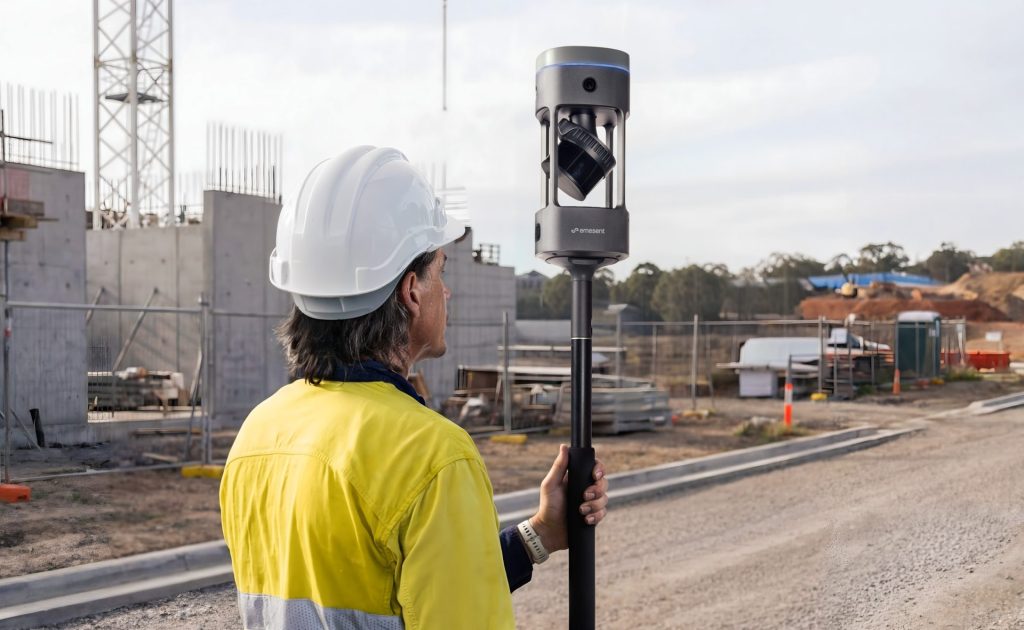
How Emesent GX1 complements existing drone LiDAR capability
The Emesent GX1 is a ground-based mobile mapping scanner that pairs naturally with aerial LiDAR workflows. It uses RTK SLAM, high-density LiDAR and 360-degree imagery to capture environments that drones can’t reach, and produces E57 point cloud outputs that integrate with the same CAD, BIM and GIS downstream platforms that aerial data feeds into.
For teams that already operate drone LiDAR, GX1 fills the ground-level gap: building interiors, tunnel and confined-space inspection, GPS-denied environments, and ground-level structural detail. The data formats are compatible, the downstream workflows are the same, and the combined dataset covers the full asset.
Coptrz is a UK partner for Emesent, offering demonstration, workflow advice, training, implementation support and after-sales care for GX1 buyers. Contact the team to discuss how GX1 fits alongside your existing aerial capability.
Frequently asked questions
No. Drone LiDAR captures from above and cannot access building interiors, underground environments, enclosed structures or GPS-denied areas. For any project that includes those environments, ground-based terrestrial LiDAR is required. The two technologies are complementary, not substitutable.
This depends on the scanner and the application. Static terrestrial laser scanning typically achieves the highest point-to-point accuracy for close-range measurement. Drone LiDAR and mobile terrestrial LiDAR trade some of that static precision for speed and coverage. For most survey and inspection deliverables, the accuracy achievable from both aerial and mobile ground-based LiDAR is appropriate.
Both produce georeferenced point clouds in standard formats such as E57 and LAS. Provided both datasets share a common coordinate reference system — which is established through the georeferencing and control approach used during each capture — they can be combined in CAD, BIM, GIS and point cloud processing platforms. Control points that appear in both datasets aid alignment where there is overlap.
The most practical starting point is to identify the project types where aerial LiDAR is currently insufficient — building interiors, tunnels, GPS-denied environments — and assess the frequency with which those projects arise or are referred elsewhere. A ground-based mobile scanner such as the Emesent GX1 addresses those gaps directly, with deployment configurations that suit a wide range of environments. Coptrz can support that evaluation with a practical demonstration.
Yes. Coptrz supplies drone-based LiDAR payloads for aerial survey applications and ground-based mobile scanning through the Emesent GX1. Contact the team to discuss the full capability range.
Next steps
If you’re looking to extend your reality capture capability into environments that aerial LiDAR can’t cover, Coptrz can advise on the right ground-based solution and support the full journey from demonstration to deployment.
View the Emesent GX1 on Coptrz or get in touch to book a demo.
Download Our FREE RPC-L1 Guide
Understand everything you need to know about moving towards commercial drone operations with our RPC-L1 guide.
- Understand what RPC-L1 is and who it is for
- Learn how the CAA transition impacts operators and training routes
- Get a clear breakdown of requirements, costs and next steps


Related Posts

Is the DJI Mavic 3 Enterprise Accurate for Surveying Work?
The DJI Mavic 3 Enterprise is a top contender for surveying work, blending precision, efficiency, and versatility into a budget-friendly package perfect for first-time and seasoned professionals alike. This drone offers various features designed to facilitate a wide range of surveying tasks, making it an invaluable tool in the arsenal of surveyors across various industries. […]

Consultation on the safe use and effective regulation of drones
The government has today announced they are set to have a consultation on proposed new measures to provide regulation of drones. The ability to provide on-the-spot fines and being able to seize the drone are being discussed in parliament. With the market set to grow at a rapid rate over the next decade, it’s imperative […]
Innovation in Action: The Parrot ANAFi Ai Drone’s Mapping Capabilities
In the fast-paced world of emergency response, every second counts. The quicker the response, the better the outcome. This is where the Parrot ANAFi Ai drone comes into play, offering a solution that is not just swift, but also accurate and efficient. The Incident Recently, a significant fire broke out at a warehouse operated by […]















