Research & Education
Drones provide advanced tools for data collection, analysis, and real-time monitoring. Their applications span a wide range of fields, including T-Levels courses, geography, archaeology, and environmental studies, offering students and researchers unique insights and practical skills.
- Data Insights
- Higher Speed
- Increased Safety
Get in contact today
Drones provide advanced tools for data collection, analysis, and real-time monitoring.

Explore The Possibilities Of Technology

Increased Speed
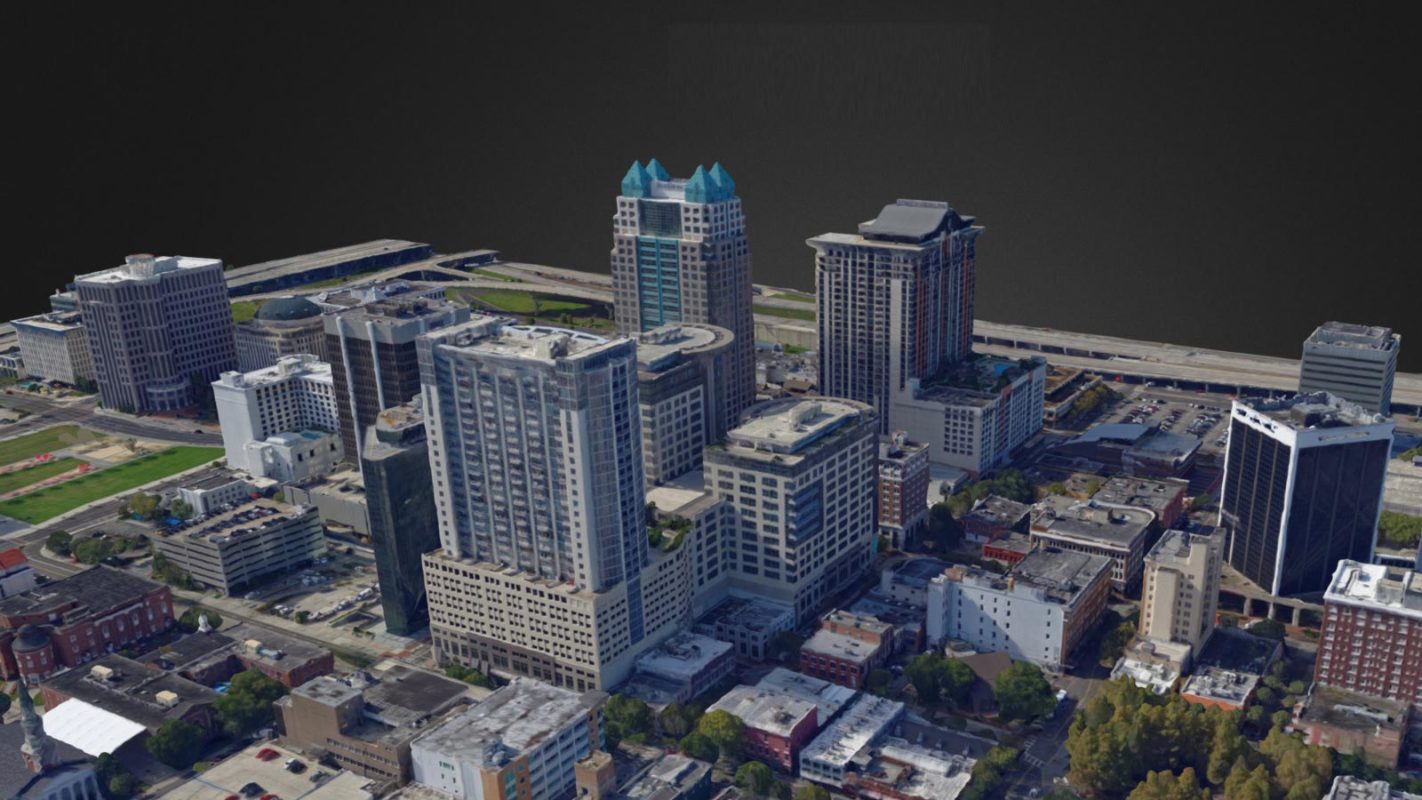
Survey a vast area in just a couple of hours rather than days. Instead of collecting 400 points with base stations, drones collect thousands of points in minutes, detailing every centimetre of the surveyed area. This data is then rendered into centimetre-accurate 3D models of the site, providing a comprehensive and precise representation.

Hands-On Learning
In educational settings, drones offer students practical experience with cutting-edge technology. Courses such as T-Levels in Design, Surveying, and Planning include drone laws and applications in their curriculum, preparing students for future industry needs. Drones are also used in university programs to teach students about 3D modelling, site surveys, and environmental monitoring.

Enhanced Data Insights
Drones equipped with high-resolution cameras, LiDAR, and multispectral sensors capture detailed aerial imagery and topographical data. This technology enables comprehensive surveys and in-depth analysis of landscapes, historical sites, and natural phenomena. For example, multispectral imagery helps track forest health and water quality, identifying pollution sources and changes in environmental conditions.
Cutting Edge Technology

Generate Prescription Maps
Drones equipped with multispectral imaging gather valuable data for environmental studies. This technology processes data to create vegetation index maps, guiding variable-rate treatments. This results in cost savings, improved yields, and significant environmental benefits, making drones an essential tool in sustainable agriculture and environmental management.
3D Modelling
Drones create detailed 3D models of construction sites and infrastructure, allowing for comprehensive analysis from a computer. Users can pan, rotate, and zoom in on models to scrutinise details and plan projects accurately.

Analysis And Annotation
Surveys can be tagged and annotated, classified by criticality. Measurement tools ensure accurate calculations for volume, mass, and dimensions for buildings and stockpiles, essential for project planning and management.

Archaeology Drones
Drones reveal sites that are often difficult to see from the ground and create digital models for detailed analysis and preservation efforts. A single drone survey increased known archaeological sites by 50% for Historic England. Using these imaging techniques like multispectral, thermal, and LiDAR is like sweeping the fog away, revealing subtle land elevation changes and soil variations that indicate the presence of archaeological features.
Geography
Drones facilitate detailed aerial mapping and site surveys, providing invaluable data for geographic studies. They enrich the study of human and physical landscapes, enabling a more nuanced understanding of spatial relationships and environmental changes. Drones can survey landforms in hours instead of days, creating 2D and 3D models to analyse river movements, erosion patterns, and sediment deposition, with year-over-year comparisons. Additionally, drones with 360-degree cameras can create VR maps of landscapes for immersive geographic analysis.


Environmental Monitoring with Drones
Drones enable non-invasive studies of species, providing insights into behaviours, population sizes, and migratory patterns. Equipped with high-resolution cameras and LiDAR, they create detailed maps and 3D models of habitats, aiding in tracking land-use changes and deforestation. Drones with sensors monitor water bodies for pollution sources, temperature changes, and pollutant levels, helping identify causes of water pollution. Additionally, multispectral imagery on drones monitors forest and plant health and assesses soil conditions, offering comprehensive environmental data.
T-Levels and Educational Programs
T-Levels, designed for 16 to 19-year-olds, incorporate drone technology to equip students with industry-relevant skills. These courses cover drone laws, data collection methods, and practical applications in fields like construction, agriculture, and environmental science.


Film & Media
Drones offer new perspectives and creative opportunities for students in film and media. They provide unique aerial shots, dynamic angles, and smooth tracking shots that were previously difficult or impossible to achieve. This technology enhances storytelling and production quality, making it an essential tool in modern cinematography.
Engineering & Robotics
Drones serve as invaluable educational tools, offering hands-on experience in aerodynamics, robotics, and coding. They bridge the gap between theoretical knowledge and practical application, enhancing students' problem-solving and innovative skills in real-world engineering challenges. By working with drones, students learn about flight dynamics, sensor integration, and automated systems, gaining practical insights into the design, development, and operation of robotic systems.


Construction
Drones capture hundreds of high-quality images of construction sites, which can be processed into survey-grade 3D and 2D models for precise measurements and volume calculations. For construction T-Level students, this hands-on experience with drones equips them with essential skills in modern surveying techniques. As drones become increasingly prevalent in the construction industry, students' drone knowledge bridges classroom learning with real-world construction challenges, preparing them for successful careers in the industry.
FAQs
Drones capture high-resolution aerial imagery and topographical data, facilitating detailed mapping and analysis of landscapes and environmental changes. This data enriches geographic studies by providing insights into spatial relationships and natural phenomena.
Drones provide low-level aerial views that reveal archaeological sites invisible from the ground. They create digital models for detailed analysis and preservation, increasing the discovery of archaeological features by detecting subtle land elevation and soil changes.
Drones monitor air and water quality, track deforestation, and observe wildlife habitats. Equipped with multispectral sensors and LiDAR, they detect changes in environmental conditions such as flooding patterns and pollution levels, providing critical data for conservation efforts.
Drones are integrated into T-Level courses to teach students about drone laws, data collection, and practical applications in various industries, preparing them for future careers. They provide hands-on experience with modern surveying techniques and project management.
Yes, drones transmit live data, allowing researchers and students to conduct immediate analysis and enhance collaborative efforts. This real-time capability improves research accuracy and decision-making.
Drones are equipped with high-resolution cameras, LiDAR, multispectral sensors, and real-time data transmission capabilities. These technologies enhance the learning experience by providing detailed and accurate data for various research applications.
Drones provide detailed and comprehensive data through advanced imaging technologies, enabling precise and efficient data collection for geographic, archaeological, and environmental studies.
Drones create detailed maps and 3D models, assisting in urban planning, infrastructure development, and environmental impact assessments. They provide accurate data that helps planners make informed decisions.
Drones offer a cost-effective alternative to traditional data collection methods, reducing the need for expensive equipment and extensive manpower. This allows educational institutions to maximise their budgets and resources.
Drones serve as invaluable tools in engineering and robotics education, offering hands-on experience in aerodynamics, coding, and automated systems. They bridge the gap between theoretical knowledge and practical application, enhancing students' problem-solving and innovation skills.
Book your FREE online consultation
Experience the unique advantage of our 360° drone solutions exclusively at Coptrz. With a network of over 20 partnerships with top-tier drone technology manufacturers, we're uniquely positioned to provide a tailored solution that you won't find elsewhere.
Impartial Expertise for
Commercial Drone Integration
End-to-end Drone Solutions
Complete drone solutions, including hardware, software, pilot training, repairs and support.
Impartial Advice
Industry experts work closely with you to find the best solution for your organisation.
UK's Widest Drone Selection
We're not limited to one brand, we offer the UK's widest range of world-renowned suppliers.