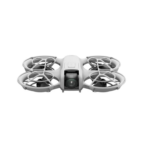
DJI Mavic 3 Multispectral
4/3 CMOS Sensor
5 Spectral Bands
Built-In RTK
See More,
Work Smarter
The DJI Mavic 3 Multispectral is an aerial surveying drone designed for precision agricultural production management. Combining 5 spectral bands with a high-resolution RGB camera, this drone collects detailed crop insights such as plant health and illness beyond what can be seen with the naked eye.
Multispectral Surveying

5 Spectral Bands

Rapid Data Collection

Crop Prescription Maps
Flight Customisation
Explore the endless possibilities of flight planning, capture, and smart features that are all packed into your Mavic 3 Enterprise.

Terrain Follow
Automatically adjust altitude when mapping areas with variations in elevation, all without needing to import external elevation data.

Intelligent Field Scouting
Automatically scout fields to detect issues like emergence deficiencies, weed pressure, and crop lodging promptly. Use AI for intelligent analyses to share real-time crop growth information, guide agronomic activities, and enable one person to manage 70 hectares efficiently.

Mission Planning
Automate your missions by planning full area coverage or defining specific routes. Simply draw a line on the map to segment the area, ensuring streamlined and efficient flight.
Seamless RTK Accuracy
Flight control, the camera, and the RTK module sync in microseconds to accurately capture the location of each camera's imaging centre for high-precision surveys without using ground control points.
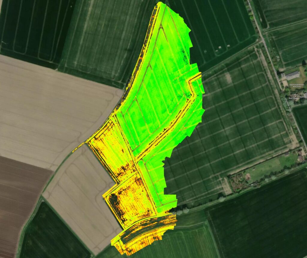
Generate High-Resolution Maps
DJI Terra / DJI SmartFarm Platform
With DJI Terra or SmartFarm Web, identify tree counts, distinguish obstacles, and formulate 3D operational routes for drones, enhancing safety and efficiency in agricultural operations.
Ultra-long battery life, for reliability and the best mission efficiency.


Feel Safe Flying
Omnidirectional obstacle sensing and terrain-follow surveying are enabled by wide-FOV vision sensors that detect obstacles in all directions, allowing for precise aerial surveying even in steep landscapes.
Applications

Precision Agriculture

Environmental Monitoring

Land Management

Research and Education

Water Enrichment Monitoring
Buy DJI Mavic 3 Multispectral
Drones


Related Training


Software


Accessories


Related products
-

Sky Hero Sigyn MkI

DJI Mavic 3 Pro
Price range: £1,879.00 through £4,109.00 Excl. VAT
DJI Mavic 3 Pro Cine
DJI Neo
Price range: £169.00 through £299.00Related Guides

Drones for Surveying Guide – Download

Multispectral Imagery Explained
Related Case Studies

Blackthorn Arable
Blackthorn Arable Ltd collaborates with Coptrz to enhance farming methods through drone technology. Using the DJI Mavic 3 Multispectral and Pix4D, they aim to make better farming decisions and optimise crop management, pioneering innovations in sustainable agriculture.


Unlock your business potential with drone technology