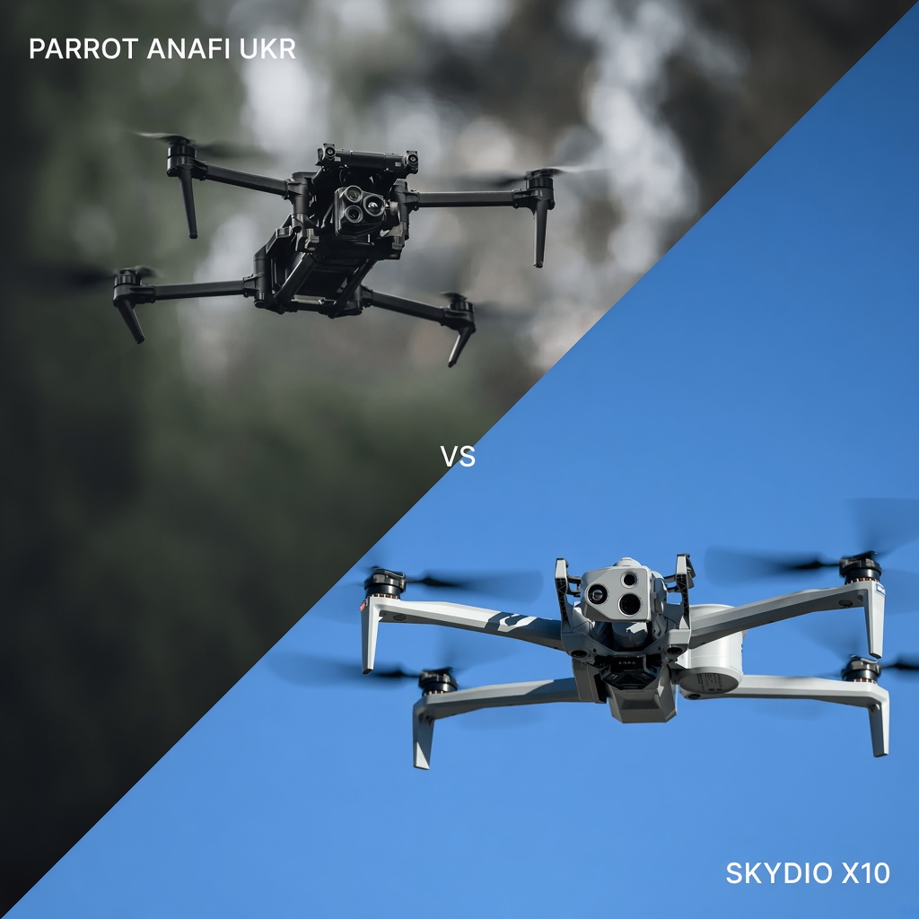
The Parrot ANAFI UKR is a lightweight, hand-launched EO/IR drone designed for operations where secure communications, rapid deployment and GNSS-denied flight are important. Coptrz supplies two configurations: the Parrot ANAFI UKR GOV, intended for public safety and government users, and the Parrot ANAFI UKR XLR, designed for defence operations requiring additional radio resilience.
The Skydio X10 is an autonomy-focused enterprise drone. Its AI-powered navigation and 360-degree obstacle avoidance allow it to navigate complex environments, automate inspection missions and operate from a dedicated docking station for remote deployment.
Both platforms offer security-focused alternatives to Chinese-manufactured drones and have documented NDAA compliance. However, they serve different operational requirements.
The Parrot ANAFI UKR prioritises secure communication, EO/IR intelligence gathering and portability. The Skydio X10 focuses on autonomous navigation, repeatable inspection missions, mapping and remote operations.
The right choice depends on the mission, operating environment, sensor requirements and the level of autonomy your team needs.
Parrot ANAFI UKR GOV, ANAFI UKR XLR and Skydio X10 compared
The following comparison covers the two ANAFI UKR configurations supplied by Coptrz and the Skydio X10 with its Connect SL communication configuration.
| Feature | Parrot ANAFI UKR GOV | Parrot ANAFI UKR XLR | Skydio X10 |
|---|---|---|---|
| Primary role | Public safety and government operations | Defence and secure ISR operations | Enterprise inspection, public safety and autonomous operations |
| Weight | 1,356 g with XLR Smart Battery | 1,356 g with XLR Smart Battery | Approximately 2.11 kg with Connect SL and batteries |
| Maximum flight time | Up to 70 minutes | Up to 70 minutes | Up to 40 minutes; approximately 35 minutes maximum hover |
| Wind resistance | Up to 15 m/s | Up to 15 m/s | Up to 12.8 m/s maximum gust |
| Ingress protection | IP53 | IP53 | IP55 |
| Operating temperature | −36°C to +50°C, subject to battery limitations | −36°C to +50°C, subject to battery limitations | −20°C to +45°C |
| Daylight camera | 21 MP with 35× EO zoom | 21 MP with 35× EO zoom | Modular sensor packages: VT300-Z, VT300-L and V100-L |
| Thermal camera | FLIR Boson, 640 × 512 | FLIR Boson, 640 × 512 | FLIR Boson+, 640 × 512, on VT300-Z and VT300-L |
| Primary communication | Wi-Fi, 5G and LoRa | MARS frequency-hopping radio, 5G and LoRa | Connect SL radio; optional Connect 5G |
| GNSS-denied capability | Optical navigation and visual-inertial positioning | Optical navigation and visual-inertial positioning | Visual-inertial navigation, hover stabilisation and obstacle avoidance |
| Obstacle protection | Stereo vision and visual-inertial navigation | Stereo vision and visual-inertial navigation | 360-degree obstacle avoidance |
| Survey positioning | Primarily EO/IR inspection and ISR | Primarily EO/IR inspection and ISR | Optional RTK/PPK for survey applications |
| Deployment | Foldable, hand-launched aircraft; under two minutes according to Coptrz | Foldable, hand-launched aircraft; under two minutes according to Coptrz | Portable deployment or optional Skydio Dock |
| Dock compatibility | Coptrz DBOX M3, subject to supported configuration | Coptrz DBOX M3, subject to supported configuration | Dedicated Skydio Dock |
| Security | AES-256 encryption; European-developed secure architecture; NDAA compliant | AES-256 encryption and MARS frequency hopping; NDAA compliant | AES-256 encryption, secure boot and encrypted storage; NDAA compliant |
Specifications reflect published manufacturer and Coptrz information. Maximum endurance, weight and communication figures depend on the selected configuration. The Parrot weight figures refer to the aircraft with the XLR Smart Battery fitted, not its maximum take-off mass.
Weight, wind resistance and deployment speed
Aircraft weight and deployment time can make a significant difference to public safety teams, emergency responders and inspection crews operating in unpredictable conditions.
Parrot ANAFI UKR: Lightweight and rapid deployment
The Parrot ANAFI UKR is designed around portability. Its foldable construction makes it suitable for teams that need to carry their aircraft between locations and deploy quickly when an incident occurs.
With the XLR Smart Battery fitted, Coptrz lists an aircraft weight of 1,356 g and a maximum flight time of up to 70 minutes.
The platform is specified with wind resistance of up to 15 m/s, including during take-off and landing, and an operating temperature range of −36°C to +50°C. However, battery temperature limitations can restrict take-off and operation at the extremes of this range.
The hand-launch and hand-landing design also removes the need for a conventional runway or large take-off area.
These characteristics make the ANAFI UKR particularly attractive for public safety teams that need to transport equipment in a response vehicle and deploy it at different incident locations.
Skydio X10: Designed for repeated autonomous missions
The Skydio X10 is a larger aircraft, weighing approximately 2.11 kg in the Connect SL configuration with batteries.
It offers up to 40 minutes of flight time and approximately 35 minutes of maximum hover time, depending on operating conditions and configuration.
Its published maximum wind-gust tolerance is 12.8 m/s, while its IP55 rating provides protection against dust ingress and water jets.
Where the ANAFI UKR prioritises rapid manual deployment, the Skydio X10 is designed for more structured and repeatable operations.
Its optional docking system allows the aircraft to remain at a fixed location, recharge between missions and launch remotely. Skydio publishes an approximately 20-second launch time from its Dock.
For organisations responsible for large facilities, infrastructure and industrial sites, this can provide a practical way to conduct recurring inspections without requiring an operator to travel to the aircraft for every deployment.
Coptrz also lists the DBOX M3 as a docking option compatible with the Parrot ANAFI UKR. This is a separate docking ecosystem from Skydio’s dedicated Dock, and compatibility should be confirmed for the exact aircraft and software configuration.
Autonomous obstacle avoidance versus resilient communication
One of the most important differences between the two platforms is how they address difficult flight environments.
The Skydio X10 focuses on autonomous navigation and obstacle avoidance. The Parrot ANAFI UKR places greater emphasis on maintaining communication and situational awareness in environments where GNSS and radio connectivity may be unreliable.
Skydio X10: 360-degree obstacle avoidance
The Skydio X10 uses multiple visual navigation sensors and onboard computing to understand its surroundings and navigate around obstacles.
Its 360-degree obstacle avoidance system helps the aircraft identify structures and maintain clearance during flight.
Skydio provides several obstacle avoidance modes, with different minimum propeller-tip clearance specifications:
- Standard: 60 cm.
- Standard narrow spaces: 39 cm.
- Close: 21 cm.
- Close narrow spaces: 13 cm.
- Minimal: 1 cm.
These are published minimum-clearance specifications for the relevant operating modes, not guaranteed distances in every environment.
This capability is particularly useful for infrastructure inspections involving bridges, towers, industrial facilities and complex structures where manually navigating around every obstacle would be challenging.
The X10 also supports autonomous waypoint missions and repeatable inspection workflows. Once a route has been planned, operators can use it to collect consistent imagery and revisit specific inspection locations.
Parrot ANAFI UKR: Communication resilience in challenging environments
The Parrot ANAFI UKR takes a different approach.
Rather than making obstacle avoidance its primary differentiator, the platform is designed around secure communication, optical navigation and multiple connectivity options.
The GOV configuration supports Wi-Fi, 5G and LoRa communication. The XLR configuration adds MARS frequency-hopping radio technology, designed to improve resilience in congested or contested electromagnetic environments.
MARS is particularly relevant for defence and government applications where conventional radio links may be disrupted or unreliable.
LoRa provides a backup communication path for basic control and telemetry. However, it should not be treated as a replacement for the primary high-bandwidth radio link or as a means of transmitting full-quality video.
The aircraft also supports optical navigation, allowing it to maintain positioning without relying entirely on satellite navigation.
Its stereo cameras and inertial sensors support visual-inertial navigation in GNSS-denied environments. Performance still depends on environmental conditions, including lighting and the availability of suitable visual features.
Neither aircraft should be treated as completely immune to communication interference, navigation errors or environmental limitations.
For teams choosing between them, the distinction is straightforward: the Skydio X10 is particularly strong when autonomous movement around obstacles is the priority, while the Parrot ANAFI UKR is designed for operations where secure and resilient communications are central to the mission.
The cameras and thermal imaging capabilities
Both platforms provide high-resolution visual and thermal imaging, but their sensor configurations are designed for different applications.
Parrot ANAFI UKR: Long-range EO/IR imaging
The Parrot ANAFI UKR GOV and XLR share the same primary imaging configuration listed by Coptrz.
Their imaging system combines:
- 21 MP daylight camera.
- Up to 35× EO zoom.
- FLIR Boson thermal camera.
- 640 × 512 thermal resolution.
- Three-axis stabilised camera system.
- Camera movement from −90° to +90°.
The combination of optical zoom and thermal imaging allows operators to inspect objects from a distance without necessarily having to fly close to them.
For public safety applications, this can be useful when monitoring incidents, locating individuals, assessing hazardous environments or gathering visual evidence from a safer position.
The thermal camera provides an additional source of information when visibility is limited or when identifying heat signatures is important.
The gimbal’s wide tilt range also allows the aircraft to look directly downwards or upwards, making it useful for inspecting roofs, building façades, overhead structures and other difficult viewing angles.
Skydio X10: Modular sensor configurations
The Skydio X10 takes a modular approach to imaging, offering different sensor packages depending on the inspection requirements.
The main configurations include:
VT300-Z
Designed for longer-range visual inspection and thermal applications.
- 64 MP narrow camera.
- 48 MP telephoto camera.
- FLIR Boson+ thermal camera.
- 640 × 512 thermal resolution.
- Thermal sensitivity below 30 mK.
This package is particularly useful when operators need to identify details from a greater stand-off distance.
VT300-L
Designed for wider visual coverage, inspection and mapping.
- 64 MP narrow camera.
- 50.3 MP wide camera.
- FLIR Boson+ thermal camera.
- 640 × 512 thermal resolution.
- Thermal sensitivity below 30 mK.
- Integrated flashlight for low-light operations.
The wider camera provides more flexibility for capturing structures and surrounding environments, while the thermal sensor supports heat-related inspections.
V100-L
A visual imaging package for operations that do not require an integrated thermal camera.
- 64 MP narrow camera.
- 50 MP wide camera.
- Integrated LED flashlight.
This provides an additional option for teams prioritising high-resolution visual inspection and mapping.
The choice between the VT300-Z, VT300-L and V100-L should be based on the required stand-off distance, field of view, thermal requirements and lighting conditions.
For teams that need both detailed thermal inspection and autonomous navigation, the X10’s modular sensor approach provides considerable flexibility.
GNSS-denied operations and positioning accuracy
GNSS-denied capability is important for both platforms, particularly when operating indoors, near large structures or in environments where satellite signals are obstructed.
However, their navigation systems and survey capabilities serve different purposes.
Parrot ANAFI UKR: Optical navigation
The ANAFI UKR uses visual-inertial navigation to support flight without relying entirely on GNSS.
Its onboard cameras and inertial measurement systems help maintain aircraft positioning by analysing the surrounding environment.
This makes it suitable for certain operations in enclosed or GPS-denied locations.
However, optical navigation requires suitable visual references. Poor lighting, reflective surfaces, repetitive patterns and featureless environments can affect positioning accuracy.
Operators should assess the environment and understand the aircraft’s navigation limitations before relying on GNSS-denied flight.
Skydio X10: Visual-inertial navigation and RTK/PPK
The Skydio X10 also uses visual-inertial navigation to maintain positioning and support obstacle avoidance.
For mapping and surveying applications, it offers an optional RTK/PPK capability.
RTK and PPK use satellite positioning corrections to improve geospatial accuracy. With a suitable configuration and correction workflow, the system can support centimetre-level positioning.
However, this is different from visual-inertial navigation. RTK/PPK accuracy depends on correction availability, satellite reception, flight planning, image quality and processing conditions.
For organisations producing orthomosaics, 3D models and other geospatial deliverables, the X10 provides a more direct surveying workflow than the ANAFI UKR.
The Parrot platform remains more focused on EO/IR intelligence gathering, situational awareness and inspection imagery.
Security, data protection and country of origin
For public-sector organisations and critical national infrastructure operators, aircraft performance is only part of the procurement decision.
Data security, supply-chain requirements, manufacturing origin and software architecture can also influence which drone is suitable for deployment.
Parrot ANAFI UKR: European-developed security architecture
Parrot is a French drone manufacturer, and the ANAFI UKR is positioned as a secure European-developed enterprise platform.
Its security features include AES-256 encryption, secure firmware mechanisms and protected data handling.
The GOV and XLR configurations are designed for different communication requirements, with MARS frequency hopping being a key differentiator of the XLR version.
Parrot announced Blue UAS, NDAA and TAA compliance for the ANAFI UKR in August 2026.
These credentials can be relevant to organisations working with government and defence procurement requirements.
Skydio X10: US-developed enterprise platform
Skydio is a US drone manufacturer, and the X10 is designed for enterprise and public-sector applications where secure hardware and software are important.
Its security architecture includes:
- AES-256 encrypted communication.
- Encrypted onboard storage.
- Secure boot and trusted firmware mechanisms.
- Protected software updates.
- Access controls and authentication features.
Skydio also identifies the X10 as NDAA compliant and describes its products as designed, assembled and supported in the United States.
For organisations assessing supply-chain risk, both manufacturers provide alternatives to Chinese-manufactured enterprise drones.
However, NDAA compliance, Blue UAS status and TAA compliance are separate procurement considerations. UK organisations should verify the specific requirements of their purchasing authority, including data residency, software access, component origin and support arrangements.
Docking systems and remote deployment
For organisations that need to conduct inspections regularly, docking systems can change how drone operations are managed.
Instead of transporting an aircraft to every inspection location, a dock allows the drone to remain at a fixed site and be deployed when required.
Skydio Dock
The Skydio X10 supports the dedicated Skydio Dock.
The system houses and charges the aircraft and supports remote operations, including scheduled and on-demand missions.
This is particularly useful for:
- Industrial facility monitoring.
- Infrastructure inspections.
- Perimeter security.
- Remote site surveillance.
- Recurring asset inspections.
The dock is designed to work as part of the wider Skydio autonomy ecosystem, allowing organisations to establish repeatable drone operations from a fixed location.
Parrot ANAFI UKR and DBOX M3
The Parrot ANAFI UKR can also be deployed through the Coptrz DBOX M3, subject to the supported aircraft configuration.
The DBOX M3 provides an alternative docking solution for organisations looking to integrate the ANAFI UKR into a fixed deployment environment.
However, it is important to distinguish this from the native Skydio Dock. The two systems have different hardware, software and integration requirements.
Before purchasing a docking solution, confirm aircraft compatibility, charging arrangements, remote connectivity, environmental protection and the level of autonomous operation supported.
Which drone should you choose?
The Parrot ANAFI UKR and Skydio X10 are both capable enterprise platforms, but their strengths make them suitable for different operational priorities.
Choose the Parrot ANAFI UKR GOV if:
- Your organisation operates in public safety, emergency response or government.
- You need a lightweight, rapidly deployable EO/IR aircraft.
- Optical zoom and thermal imaging are important to your missions.
- You need multiple communication options, including 5G and LoRa.
- You regularly operate in GNSS-denied environments.
- You want a portable aircraft that can be deployed directly from a response vehicle.
The GOV configuration is particularly suitable for public safety teams that need reliable visual intelligence, thermal imaging and flexible communication options.
Choose the Parrot ANAFI UKR XLR if:
- Your operations involve defence or security applications.
- Communication resilience is a major operational requirement.
- You need MARS frequency-hopping radio technology.
- You want the same EO/IR imaging capabilities as the GOV configuration.
- Your team operates in environments where conventional wireless links may be unreliable or contested.
The XLR is the more appropriate configuration when the radio environment is a central concern rather than simply an additional specification.
Choose the Skydio X10 if:
- You need autonomous obstacle avoidance in complex environments.
- Your inspections involve bridges, towers, industrial structures or large facilities.
- You want repeatable waypoint missions and automated inspection workflows.
- You require optional RTK/PPK capabilities for mapping and surveying.
- You want to establish remote drone operations using a dedicated docking system.
- You need different imaging configurations for visual, thermal and mapping applications.
The Skydio X10 is particularly suitable for organisations that want to make autonomous inspection and recurring drone deployment part of their everyday operations.
Can an organisation benefit from both?
Yes. The two platforms are not necessarily direct replacements for one another.
A public safety organisation might use the Parrot ANAFI UKR GOV for rapid deployment, thermal imaging and incident monitoring, while using the Skydio X10 for recurring inspections and autonomous operations around complex infrastructure.
Similarly, a defence or security organisation may prioritise the ANAFI UKR XLR’s communication capabilities while using a separate autonomous platform for infrastructure assessment.
The best fleet configuration depends on the missions your organisation performs most frequently, rather than choosing a drone based solely on its headline specifications.
UK Operating Requirements and Training
Both aircraft require operators to consider the applicable UK Civil Aviation Authority regulations before deployment.
Although their weights exceed 250 g, this does not automatically mean that every operation must take place under a Specific-category authorisation.
The applicable category depends on factors such as the aircraft’s class marking or legacy status, maximum take-off mass, operating environment and intended mission.
Some operations may be possible under the Open category where all relevant conditions and restrictions are met. More complex operations, including certain BVLOS and remote dock-based missions, may require a Specific-category authorisation.
Organisations should also ensure that their operational procedures, insurance, pilot competency and risk assessments are appropriate for the aircraft and intended use.
For teams moving to the Parrot ANAFI UKR, Coptrz Academy currently lists model-specific training for the Parrot ANAFI USA. However, the ANAFI USA and ANAFI UKR are different configurations, so operators should confirm the applicable training programme before booking.
For public safety organisations, additional training in operational planning, evidence collection and safe deployment is also valuable.
The aircraft is only one part of a successful drone programme. Operators need to understand its communication systems, navigation limitations, payloads and the procedures required for their specific missions.
Frequently Asked Questions
Which drone has better obstacle avoidance, the Parrot ANAFI UKR or Skydio X10?
The Skydio X10 has the more advanced autonomous obstacle avoidance system, with 360-degree visual sensing and multiple clearance modes. The Parrot ANAFI UKR uses stereo vision and visual-inertial navigation, but its main strengths are secure communication and GNSS-denied operation rather than autonomous obstacle navigation.
Can the Parrot ANAFI UKR fly without GPS?
Yes. The Parrot ANAFI UKR supports GNSS-denied flight using optical navigation and visual-inertial positioning. However, its performance depends on environmental conditions, including sufficient lighting and visual references. It should not be assumed to navigate every indoor environment without limitations.
Which drone has better wind resistance?
The Parrot ANAFI UKR has a published wind resistance figure of up to 15 m/s, compared with the Skydio X10’s published maximum gust tolerance of 12.8 m/s. These figures use different manufacturer test descriptions, so they should be treated as planning specifications rather than a direct guarantee of comparative performance.
Is the Skydio X10 better for mapping?
The Skydio X10 is the stronger option for dedicated mapping workflows. Its VT300-L visual sensor package supports wide-area image capture, while optional RTK/PPK capabilities provide improved geospatial positioning. The Parrot ANAFI UKR is primarily designed for EO/IR intelligence gathering and inspection rather than survey-grade mapping.
What is the difference between the Parrot ANAFI UKR GOV and XLR?
Both versions share the same basic aircraft platform and imaging system. The main difference is their communication configuration. The GOV is designed for public safety and government users, with Wi-Fi, 5G and LoRa connectivity. The XLR adds MARS frequency-hopping radio technology for operations requiring greater communication resilience.
Are the Parrot ANAFI UKR and Skydio X10 NDAA compliant?
Yes. Both manufacturers publish NDAA compliance for their respective platforms. Parrot also announced Blue UAS and TAA compliance for the ANAFI UKR in August 2026. Organisations should still verify the applicable procurement requirements and the compliance documentation for the exact configuration being purchased.
Discuss the Parrot ANAFI UKR with Coptrz
Selecting an enterprise drone requires more than comparing flight times and camera specifications. The right platform needs to match your organisation’s operational requirements, communication environment, security policies and inspection objectives.
The Parrot ANAFI UKR GOV offers a portable EO/IR solution for public safety and government operations, while the ANAFI UKR XLR adds MARS frequency-hopping communication for defence applications.
The Skydio X10 offers a different approach, focusing on autonomous navigation, 360-degree obstacle avoidance, modular imaging and remote deployment through its dedicated docking system.
If you are considering either platform for your organisation, Coptrz can help you assess the available configurations and identify the most suitable equipment for your requirements.
Request information on the Parrot ANAFI UKR to explore its GOV and XLR configurations, imaging capabilities and communication options.
To discuss your operational requirements, including how the Parrot ANAFI UKR compares with the Skydio X10, contact our team or call 0330 111 7177 for a tailored UK quotation.
Download Our FREE RPC-L1 Guide
Understand everything you need to know about moving towards commercial drone operations with our RPC-L1 guide.
- Understand what RPC-L1 is and who it is for
- Learn how the CAA transition impacts operators and training routes
- Get a clear breakdown of requirements, costs and next steps
Related Posts

DJI Modify Tutorial: How To Use DJI’s 3D Model Editing Software
The launch of DJI Modify marks a significant milestone in the world of drone technology and 3D modelling. This highly anticipated release, especially with its offer of a free 6-month public beta license, has created a buzz among enthusiasts and professionals alike who are eager to explore the capabilities of this new software. DJI Modify […]
Matrice 200 Series: Part 2 – The Payloads
This is the second part of a two-part series taking an in-depth look at the Matrice 200 Series. This part looks at a number of different payloads that can be used to enhance your data capturing capabilities. The series features the DJI Matrice 200, as well as the DJI Matrice 210 and M210 RTK. Described […]
Drones in Forestry: How are UAVs making a difference?
Drones in Modern Forestry Advancements in technology are happening every day. The drone industry is expanding and therefore drones are finding their way into new industries. Drones in forestry is a relatively new concept that is getting bigger by the day. Drones can go where humans can’t, the possibilities of what drones can do for […]