UK survey teams are being asked to do more with the same resource. Larger sites, tighter deadlines, fewer return visits, and clients who expect deliverable-ready data rather than raw files. RTK SLAM is becoming an important part of that conversation – not because it replaces every existing tool, but because it closes a real gap between mobile scanning speed and the georeferencing confidence that survey-grade work demands.
This guide explains what RTK SLAM is, why it matters in a UK survey context, and where it fits alongside the rest of your reality capture toolkit.
What is SLAM?
SLAM stands for simultaneous localisation and mapping. In practice, it means a scanner that builds a 3D map of its environment while also continuously calculating its own position within that environment – at the same time, from the same sensor data.
This is what makes mobile scanning possible. Rather than setting up a static scanner at fixed positions and stitching the results together in post-processing, a SLAM-based scanner can move continuously through a building, corridor, tunnel or site while generating a dense point cloud in real time. The scanner knows where it is because it’s tracking the geometry around it as it moves.
SLAM has been available for several years, but the early knock against it was accuracy. Mobile scanning was fast, but survey teams couldn’t always defend the outputs in projects where coordinate accuracy mattered. RTK changes that.
What does RTK add to SLAM?
RTK stands for real-time kinematic positioning. It’s a GNSS correction technique that significantly improves the accuracy of satellite-based positioning by using reference station data to resolve positioning errors in real time.
In a SLAM workflow, integrating RTK means the scanner’s position isn’t just tracked through geometry – it’s continuously corrected against a known reference frame. The result is a mobile scan that can be tied into a project coordinate system with much greater confidence than GNSS alone would allow.
For surveying applications, this is significant. The value isn’t just a more accurate coordinate – it’s confidence that mobile-captured data can meet the georeferencing standards that design teams, BIM workflows, and asset records actually require. Many RTK SLAM scanners also support PPK (post-processed kinematic) positioning, which applies the same correction data after capture rather than in real time, and is useful where live GNSS correction isn’t available on site.
Why does RTK SLAM matter commercially for UK survey teams?
The commercial case comes down to field productivity and data confidence.
Fewer return visits. One of the biggest costs in survey work isn’t capture time – it’s going back. Missed areas, registration failures, and data quality issues that only emerge in post-processing are expensive. RTK SLAM reduces the risk of each of those, because the scanner captures continuously, imagery is embedded alongside geometry, and the georeferencing is applied during capture rather than retrospectively.
More output from the same crew. A mobile scanning workflow covers significantly more area per day than a static laser scanner setup. For survey firms handling multiple projects simultaneously, the capacity uplift compounds quickly.
Data that’s ready for downstream use. Point clouds from RTK SLAM workflows can be exported in E57 and other standard formats, and integrated directly into CAD, Revit, BIM and GIS environments. The data meets clients where they work, rather than requiring additional processing steps to become usable.
Competitive positioning. UK infrastructure, energy, water and rail programmes are all creating increased demand for repeatable, accurate site data. Survey firms that can offer faster capture with defensible accuracy are better placed to win and retain work in those sectors. For more on how drone and LiDAR technology is being applied across those industries, see our LiDAR technology capability page and surveying and construction sector page.
Where does Emesent GX1 fit?
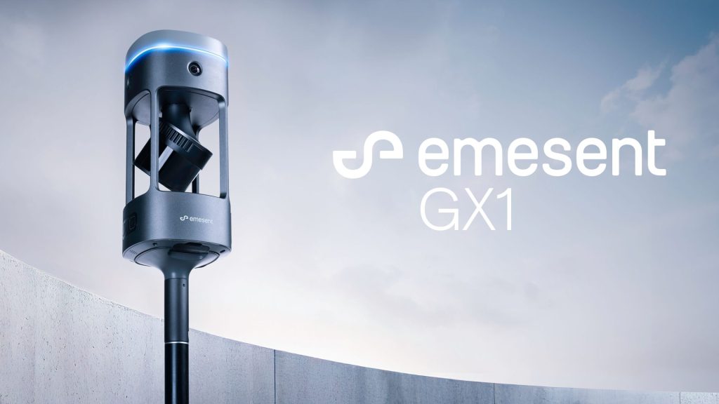
The Emesent GX1 is a ground-based mobile mapping scanner that combines RTK SLAM, high-density LiDAR and 360-degree imagery in a single field-ready platform.
It’s built for survey-grade workflows. Emesent states 5-10 mm global accuracy, 5 mm local accuracy, and 15 mm RTK/PPK accuracy – positioning it as a step beyond conventional mobile SLAM in terms of the accuracy claims it can support. The scanner also carries four 20 MP cameras capturing 360-degree imagery alongside the LiDAR data, which means site visits produce both geometric and visual context in a single pass.
Deployment is flexible. GX1 can be used as a backpack, mounted on a pole, attached to a vehicle, or used in a supported handheld configuration – which means the same scanner adapts to topographic surveys, building capture, corridor mapping, infrastructure inspection, and confined-space or GPS-denied environments where drone-based LiDAR can’t reach.
Processing runs through Emesent’s Aura software, with E57 exports and compatibility with standard CAD and BIM workflows.
Coptrz is a UK partner for Emesent GX1, offering demonstration, workflow advice, training, implementation support and after-sales care. You can view the full Emesent brand page for more on the partnership and available products.
Where does RTK SLAM fit in a wider reality capture workflow?
RTK SLAM isn’t the right tool for every job, and the strongest workflows usually combine it with complementary methods rather than replacing everything else.
Use RTK SLAM where it’s strongest:
- Large or complex indoor environments where static scanner setup time is prohibitive
- Road corridors, bridges and linear infrastructure requiring continuous capture
- Construction sites needing repeatable progress records and as-built documentation
- GPS-denied environments – tunnels, confined spaces, dense urban canyons – where drone-based LiDAR can’t operate
- Scan-to-BIM projects where capture speed and rich visual context both matter
- Industrial facilities and treatment works where access windows are constrained
Where static TLS still has a role:
Very high-control tasks – monitoring, precise deformation analysis, or projects with strict accuracy tolerances that need to be verified against a known benchmark – may still require terrestrial laser scanning for selected measurement points. The strongest approach is often to use RTK SLAM for the bulk of site capture and TLS selectively where absolute accuracy is critical.
Where aerial LiDAR complements it:
Drone-based LiDAR is well-suited to large open areas, elevated structures and hard-to-access assets from above. RTK SLAM covers what drones miss: ground-level detail, interiors, covered structures, and occluded areas. For more on how aerial and terrestrial LiDAR work together, see our RTK drones capability page.
The commercial question isn’t which technology wins – it’s which combination reduces your field time, eliminates return visits and produces data your clients can use.

Key applications for UK survey teams
Topographic surveys – capture dense geometry across large areas faster than a total station or static scanner setup, with RTK positioning tying the data into the project reference frame on site.
Scan-to-BIM and measured building surveys – fast building capture with embedded 360-degree imagery, reducing the number of site visits needed before modelling can begin. E57 outputs integrate directly into Revit and AutoCAD workflows.
Construction progress and as-builts – repeatable mobile capture creates a measurable, timestamped site record. As-built documentation captured this way reduces handover disputes and gives contractors defensible evidence.
Infrastructure inspection – bridges, highways, rail corridors and utilities all benefit from continuous capture during access windows. RTK/PPK positioning means data from constrained access environments can still be georeferenced accurately.
Digital twins – point cloud and 360-degree imagery from RTK SLAM provides the reality capture foundation that digital twin workflows depend on. Poor input data creates a poor twin; survey-grade mobile mapping creates a stronger baseline.
Frequently asked questions
RTK SLAM is a type of mobile scanning technology that lets a LiDAR scanner move through an environment and generate a 3D point cloud while continuously tracking its own position using satellite positioning corrections. The result is georeferenced scan data captured at walking pace, without setting up a tripod.
It depends on the project. For many survey, construction and infrastructure applications, the accuracy levels achievable with current RTK SLAM scanners – such as the Emesent GX1’s stated 5–10 mm global accuracy – are appropriate. For very high-precision tasks such as structural monitoring or legal boundary surveys, additional control and verification steps may be needed. The only way to know for your specific project is to test it against your control and deliverable requirements.
Static TLS typically achieves higher point-to-point accuracy at short range, and remains the standard for very high-control tasks. RTK SLAM trades some of that static precision for significantly faster capture across larger and more complex environments. Many teams use both: mobile SLAM for bulk capture, TLS for selective control measurement.
Yes. The SLAM element – tracking position through environmental geometry – operates independently of satellite signal. RTK/PPK positioning enhances outdoor and open-sky accuracy, but the scanner continues to function in areas where GNSS is unavailable, including tunnels, basements and dense indoor environments.
The primary output is a georeferenced point cloud, typically available in E57 and other standard formats. Many scanners, including the GX1, also capture 360-degree imagery alongside the LiDAR data. These outputs integrate with CAD, Revit, BIM and GIS platforms.
Yes. Coptrz provides demonstration, workflow advice, training, implementation support and after-sales care for GX1 buyers in the UK. Contact the team to discuss your project requirements or arrange a practical workflow demo.
Next steps
If you’re evaluating RTK SLAM for your survey workflow, the best starting point is a practical demonstration against a real use case – not a spec sheet comparison. Bring a project, an output requirement and a current workflow pain, and let the results speak.
View the Emesent GX1 on Coptrz or get in touch to arrange a demo.
Download Our FREE RPC-L1 Guide
Understand everything you need to know about moving towards commercial drone operations with our RPC-L1 guide.
- Understand what RPC-L1 is and who it is for
- Learn how the CAA transition impacts operators and training routes
- Get a clear breakdown of requirements, costs and next steps


Related Posts

DJI Air 3 vs DJI Mavic 2 Enterprise: A Comparative Review
As drone technology continues to evolve, DJI remains at the forefront of innovation. Two of their standout models, the upcoming DJI Air 3 and the existing DJI Mavic 2 Enterprise (M2E), offer unique features that cater to different user needs. But which is more suited for you? In today’s blog, we’ll compare these two drones, […]

How to maintain a safe environment whilst flying your drone
When flying your drone, you are the sole person responsible for ensuring that it’s flown in a safe manner. This does not just include the safety of the drone itself, but also considering the safety of yourself, other people in the area and the environment too. Whether you are flying for surveys, filming or just […]

Join the ‘Inner Circle’ for Commercial Drone Pilots
Join the ‘Inner Circle’ of Commercial Drone Pilots and leverage an incredible opportunity to learn from the experience, network and know-how of our founders, Steve Coulson and Paul Luen. Inner Circle is an exclusive group of Commercial Drone Pilots that have access to COPTRZ trainers and a peer support network. This group has an exclusive […]















