Infrastructure and asset inspection is one of the strongest use cases for LiDAR scanning, and one of the most varied. Bridges, tunnels, highways, rail corridors, water treatment works, energy assets and utility networks all have different access conditions, accuracy requirements, operational constraints and deliverable expectations. That variety is exactly why “which LiDAR scanner is best for infrastructure inspection” doesn’t have a single answer — it depends on what you’re inspecting, how you’re accessing it, and what the output needs to do.
This guide covers the evaluation criteria that matter for infrastructure and asset inspection, and where different scanner types — including mobile RTK SLAM and drone-based LiDAR — sit against those criteria.
What makes infrastructure inspection different from standard survey work
Infrastructure inspection has a set of requirements that pushes standard survey workflows to their limits.
Access is constrained. Rail possessions, highway lane closures, confined entries, elevated structures and live operational assets all impose restrictions on how long a team can be on site, what equipment they can deploy and where they can physically go. A scanner that requires lengthy setup and multiple static positions is a poor fit for a two-hour possession window.
The asset doesn’t stop. Many infrastructure assets are live. Inspections happen during limited access windows, and missing something means waiting for the next window — which may be weeks away. The cost of a return visit is not just the survey fee; it’s the access cost, the operational disruption and the programme delay.
Deliverables feed multiple downstream uses. Infrastructure inspection data typically needs to serve condition reporting, asset registers, maintenance planning, structural analysis, digital twin creation and regulatory compliance. The scanner needs to produce outputs that work across those destinations, not just one.
Environments are often GPS-denied or geometrically complex. Tunnels, culverts, enclosed bridges, substations and below-ground assets are all environments where GNSS is unreliable or unavailable. A scanner that depends entirely on satellite positioning will struggle in these conditions.
The key criteria for evaluating a LiDAR scanner for infrastructure inspection
Deployment speed and setup burden
On infrastructure assets with constrained access windows, setup time is not a minor inconvenience — it’s a significant proportion of the available capture time. A scanner that requires levelling, target placement, and multiple static positions before capture can begin consumes access time that could be spent capturing data.
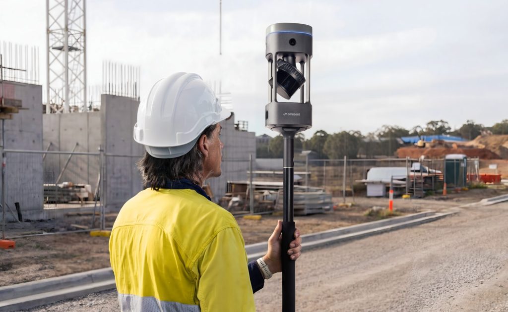
Mobile scanners have a clear advantage here. Deploy, walk, capture. For rail possessions, highway closures and operational plant shutdowns, the ability to begin capturing within minutes of arriving on site is commercially significant.
GPS-denied performance
Infrastructure environments regularly include areas where GNSS signal is weak or absent. Tunnels are the obvious example, but bridges with enclosed decks, subterranean utility chambers, indoor substations and dense urban canyon environments all present the same challenge.
RTK SLAM scanners track position through environmental geometry rather than satellite signal, which means they continue to function in GPS-denied areas. This is a fundamental capability requirement for many infrastructure inspection applications, not a nice-to-have.
Accuracy relative to deliverable requirements
Infrastructure inspection accuracy requirements vary considerably by application. Condition surveys and asset registers typically require less precision than structural monitoring or clearance gauging. Matching scanner accuracy to deliverable requirement — rather than defaulting to the highest-accuracy option in all cases — is the right evaluation approach.
Current RTK SLAM scanners achieve accuracy levels that are appropriate for a wide range of infrastructure inspection deliverables. For applications requiring sub-millimetre precision or long-term monitoring against a known baseline, static TLS may still be required for control measurements. For most condition documentation, asset capture and corridor survey applications, mobile scanning is sufficient.
Integrated imagery
Point cloud data tells you where things are. Imagery tells you what they look like. For infrastructure inspection — where condition assessment, defect recording, and asset classification all require visual evidence alongside geometry — a scanner that captures both in a single pass is significantly more efficient than one requiring a separate photography stage.
For more on how LiDAR and imagery combine in inspection workflows, see our LiDAR technology capability page.
Flexible deployment configurations
Different infrastructure environments require different scanner configurations. A backpack is appropriate for a tunnel walkthrough but impractical for a bridge deck inspection where a vehicle mount is safer and faster. A pole configuration suits confined manholes and culverts. Vehicle mounting suits road and rail corridor surveys. The scanner that fits most infrastructure inspection use cases is one that adapts to multiple deployment modes without requiring separate hardware.
Output compatibility
Infrastructure asset data feeds into a wide range of downstream platforms: GIS, asset management systems, BIM environments, structural analysis tools and digital twin platforms. The scanner’s outputs — point cloud formats, imagery standards, georeferencing methods — need to be compatible with those downstream destinations. E57 is the standard interchange format; GNSS-referenced outputs are required for assets that sit within a wider spatial data framework.

Where aerial LiDAR fits in infrastructure inspection
Drone-based LiDAR has a clear role in infrastructure inspection for assets where aerial access is the most practical approach: bridge decks and soffits, elevated highway structures, embankments, flood defence assets, power line corridors and large above-ground structures. For those applications, aerial LiDAR reduces the need for rope access, cherry pickers and other expensive access methods.
The limitation of drone-based LiDAR is that it can’t follow assets underground, into enclosed structures, or through environments where flight is not possible. Ground-based mobile LiDAR covers what aerial can’t reach. The strongest infrastructure inspection capability combines both: drone for above-ground and large-area capture, ground-based mobile for interiors, underground sections and GPS-denied environments. For more on aerial LiDAR capability, see our RTK drones page.
Where Emesent GX1 fits in infrastructure inspection
The Emesent GX1 is a ground-based mobile mapping scanner combining RTK SLAM, high-density LiDAR and 360-degree imagery. It is deployable in backpack, pole, vehicle and supported handheld configurations, which gives it practical coverage across a wide range of infrastructure inspection scenarios.
Its GPS-denied performance makes it directly applicable to tunnels, enclosed bridges, below-ground utilities and other environments where aerial or GPS-dependent scanners cannot operate. Key specifications: Emesent states 5–10 mm global accuracy, 5 mm local accuracy, and 15 mm RTK/PPK accuracy, with a 300 m LiDAR range, integrated RTK/PPK, four 20 MP cameras, an IP65 environmental rating, and multiple deployment modes — all relevant to built-environment and asset workflows where dense data, visual context and operational resilience are required.
Outputs from GX1 are available in E57 and other standard formats, with compatibility with GIS, BIM, asset management and digital twin platforms. Processing runs through Emesent’s Aura software. Coptrz supports UK buyers with demonstration, workflow review, training and after-sales care — find the full product range on our Emesent brand page, and see how it fits into UK infrastructure workflows on our surveying and construction sector page.

Implementation and support: why it matters as much as hardware
Buying a LiDAR scanner without adequate workflow support is a common and expensive mistake. Infrastructure teams need more than hardware delivery — they need training, data processing guidance, output validation against project requirements, and after-sales support when field conditions don’t match the demo environment.
This is where supplier selection matters as much as scanner selection. A supplier that can demonstrate the workflow on your asset type, validate the outputs against your deliverable requirements, and support the team through the first projects significantly reduces implementation risk. Coptrz positions its GX1 offer around implementation, not just supply — speak to the team to discuss how that looks for your inspection programme.
A framework for choosing the right scanner
Rather than asking “which is the best LiDAR scanner for infrastructure inspection,” the more useful question is: which scanner best fits this specific inspection task? A simple evaluation framework:
- Is the asset above ground and accessible by air? Drone-based LiDAR is likely the most efficient primary capture method.
- Is the asset underground, enclosed or GPS-denied? Ground-based mobile scanning with RTK SLAM is required.
- Is the access window short? Mobile scanning’s faster deployment is a significant advantage.
- Does the deliverable require sub-millimetre precision? Static TLS may be needed for control measurements alongside mobile capture.
- Does the output need to feed a digital twin or asset management system? Confirm output format compatibility with those platforms before selecting a scanner.
For most infrastructure inspection applications, the answer will combine aerial and ground-based mobile LiDAR, with static scanning reserved for selective control work where the accuracy requirement demands it.
Frequently asked questions
Tunnels require a scanner that works in GPS-denied environments and can be deployed quickly within a possession or access window. Ground-based mobile RTK SLAM scanners — such as the Emesent GX1, which can be vehicle-mounted for rail and road tunnels or backpack-deployed for pedestrian access — are well-suited to tunnel inspection. Static TLS can be used for control points where very high precision is required.
LiDAR augments rather than replaces inspection. It produces spatial and visual data that supports condition assessment, asset records and structural analysis, but interpretation by qualified inspectors and engineers remains necessary. The value is in faster, more complete data capture rather than in removing the inspection expertise.
Point cloud data from LiDAR inspection, together with embedded imagery, can be imported into GIS and asset management platforms in standard formats such as E57. Many asset management systems also accept Aura Cloud outputs directly. The specific integration path depends on the platform in use.
Drone LiDAR is best suited to above-ground assets accessible by air — bridges, embankments, power line corridors, elevated structures. Ground-based mobile LiDAR covers what drones can’t reach: interiors, underground sections, enclosed structures and GPS-denied environments. Most comprehensive infrastructure inspection programmes use both.
Yes. Coptrz supports UK infrastructure teams with scanner evaluation, practical demonstrations, workflow advice and implementation support. Contact the team to discuss your inspection application and arrange a demo.
Next steps
The right LiDAR scanner for infrastructure and asset inspection depends on the specific asset, access conditions and deliverable requirements. If you’re evaluating options, Coptrz can advise on scanner selection, run a practical demonstration and support the full implementation journey.
View the Emesent GX1 on Coptrz or get in touch to book a demo.
Download Our FREE RPC-L1 Guide
Understand everything you need to know about moving towards commercial drone operations with our RPC-L1 guide.
- Understand what RPC-L1 is and who it is for
- Learn how the CAA transition impacts operators and training routes
- Get a clear breakdown of requirements, costs and next steps


Related Posts
COPTRZ DRONE-FLX Leasing Solution Now Available
COPTRZ has today announced the release of DRONE-FLX, an industry-first leasing solution that provides a cost-effective way for businesses and public bodies to enjoy the benefits of the latest drone technology. With costs spread over a three-year period, the latest drone hardware can be bundled with training and software to enable an effective drone strategy […]
Understanding Drone Payloads
You’ll have heard us talking about payloads all over the site – but what exactly is it, and how does it affect your drone purchase choices? Payload: The Definition In short, the payload is the weight a drone or unmanned aerial vehicle (UAV) can carry. It is usually counted outside of the weight of the […]

Top Collision Avoidance Drones
Collision avoidance systems used to be reserved for expensive commercial and military drones. However, as the sensors become more affordable, we are starting to see the technology on more accessible light domestic drones. The first light consumer drone with sonar obstacle detection came on the market about three years ago. They offered a single plane […]














