Scan-to-BIM and measured building surveys share a common pressure point: the gap between site and desk. Data captured on site has to travel through post-processing, registration, and modelling before it becomes useful — and every weakness in the capture stage adds time, cost and risk of return visits to that journey. Mobile mapping changes where that pressure sits.
This post covers how mobile mapping applies to Scan-to-BIM and measured building workflows, where it improves on static scanning, and how Emesent GX1 fits into those workflows for UK survey teams.
What the workflow looks like today
Most Scan-to-BIM and measured building workflows still rely on static terrestrial laser scanning as the primary capture method. A survey team sets up at multiple stations, captures overlapping scans, registers them in post-processing, and delivers a point cloud that a modeller then works from to produce the BIM model or measured drawing set.
It works. The accuracy is well understood, the deliverables are established, and clients and BIM teams know what to expect. The limitation is field productivity. On large or complex buildings — multi-storey, mixed-use, historic fabric, heavily partitioned — the number of scanner positions required to achieve adequate coverage multiplies quickly. Setup, levelling, scanning, moving, and re-registering is time-intensive. Missed areas or registration failures send teams back to site.
For survey firms pricing competitively and managing multiple projects simultaneously, that field time is often where margin disappears.
What mobile mapping adds to these workflows
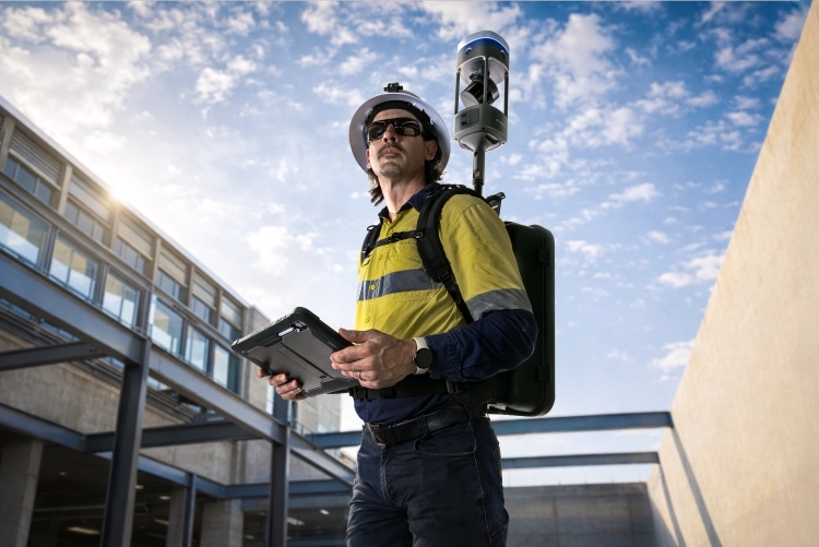
Mobile mapping replaces the static station-by-station approach with continuous capture. The surveyor moves through the building — carrying the scanner in a backpack, on a pole, or in a supported handheld configuration — while the scanner builds a point cloud in real time using SLAM (simultaneous localisation and mapping).
For Scan-to-BIM and measured building surveys specifically, the advantages are significant:
Faster coverage. A mobile scanner can capture a floor plate, staircore, plant room and roof terrace in a fraction of the time a static scanner requires to cover the same area. On multi-storey buildings, the cumulative time saving across floors is substantial.
360-degree imagery embedded in the same pass. For measured building surveys, visual context is as important as geometry. Mobile scanners like the GX1 capture 360-degree imagery alongside the LiDAR data, which means the survey team leaves site with both the point cloud and the photographic record needed for drawing production — without a separate walkthrough.
Missed areas caught on site. Because the point cloud builds in real time and can be monitored during capture, gaps are visible before the team leaves. With static scanning, registration failures and missed areas often only emerge in post-processing, after the team has gone. A return visit becomes necessary. Mobile capture shifts that quality check to the field.
Simpler post-processing. Static scan registration — stitching multiple scans together using targets or cloud-to-cloud methods — is a significant post-processing burden. Mobile scanning produces a single continuous dataset, which reduces that burden and accelerates the time from capture to deliverable.
Where accuracy sits in a mobile mapping Scan-to-BIM workflow
The most common concern about mobile mapping in survey-grade workflows is accuracy. For Scan-to-BIM and measured building applications, the question is whether mobile capture can meet the accuracy requirements of the deliverable — typically measured drawing sets, Revit models, or BIM outputs at LOD 200–350.
For the majority of those applications, current RTK SLAM scanners are accurate enough. Emesent states that GX1 delivers 5–10 mm global accuracy, 5 mm local accuracy, and 15 mm RTK/PPK accuracy. For measured building surveys and Scan-to-BIM workflows where the deliverable is a coordinated model rather than a millimetre-precision structural survey, those figures are appropriate.
Control points remain important. Mobile mapping doesn’t remove the need for survey control — it changes where and how that control is applied. Establishing a small number of control targets within the building, captured with GPS or total station, and tying the mobile scan to those points is standard practice. This ensures the dataset is correctly georeferenced and any drift in the SLAM trajectory is corrected.
For a broader view of how LiDAR accuracy applies across different survey applications, see our LiDAR technology capability page.
Where mobile mapping is strongest in building surveys
Large or complex floor plates — open-plan offices, warehouses, retail units, education buildings and healthcare facilities where coverage area is high and static scanner setup time becomes prohibitive.
Multi-storey buildings — stair cores, plant rooms, service risers and intermediate levels that require repeated scanner moves in static workflows are captured more efficiently in a single mobile pass.w
Historic and existing fabric — buildings with irregular geometry, non-orthogonal walls, vaulted ceilings or complex internal arrangements where static scanner registration is challenging and visual context is critical for interpretation.
Constrained access environments — plant rooms, basements, service voids and other spaces where setting up a tripod is impractical or impossible. Mobile capture continues to function in GPS-denied environments because the SLAM engine tracks position through geometry, not satellite signal.
Projects with tight access windows — occupied buildings, live retail or hospitality environments where the survey team has limited time on site. Faster mobile capture maximises what can be achieved in a constrained window.

How GX1 fits into a Scan-to-BIM workflow
The Emesent GX1 is a ground-based mobile mapping scanner combining RTK SLAM, high-density LiDAR and four 20 MP cameras capturing 360-degree imagery. It is deployable as a backpack, pole-mount or supported handheld, which means it adapts to the access and geometry of most building environments.
Processing runs through Emesent’s Aura software. Point cloud outputs are available in E57 and other standard formats, which integrate directly with Autodesk Revit, AutoCAD, Bentley and other BIM and CAD platforms. The 360-degree imagery is accessible alongside the point cloud, providing the visual reference that modellers and drawing producers need without a separate site visit.
Coptrz is a UK partner for Emesent, providing demonstration, workflow advice, training, implementation support and after-sales care. Find out more about the full Emesent product range on our Emesent brand page, or see how mobile mapping sits alongside aerial survey capability on our surveying and construction sector page.
Hybrid workflows: when to combine mobile and static scanning
Mobile mapping doesn’t replace static scanning in every situation. For measured building surveys involving historic structures where very fine detail is required, or for control-critical elements such as structural deflection monitoring, a static scanner may still be needed for selected measurements.
The strongest approach for many Scan-to-BIM projects is hybrid: use mobile mapping for the bulk of building capture — floor plates, circulation, services, external fabric — and deploy a static scanner selectively where the geometry or accuracy requirement demands it. This combines the productivity of mobile capture with the precision of static scanning where it actually matters.
For survey firms that also operate aerial LiDAR alongside building survey, the same logic applies: ground-based mobile mapping for interiors and ground-level detail, drone-based LiDAR for roofscapes, facades and surrounding site. For more on how aerial and terrestrial capability combine, see our RTK drones page.
Frequently asked questions
For most Scan-to-BIM deliverables at LOD 200–350, yes. Emesent states GX1 delivers 5–10 mm global accuracy and 5 mm local accuracy, which is appropriate for coordinated BIM models and measured drawing sets. Control points should still be established to georeference the dataset and verify accuracy against project requirements.
The primary output is a georeferenced point cloud in E57 or other standard formats, alongside 360-degree imagery captured in the same pass. These integrate with Revit, AutoCAD, Bentley and other BIM and CAD platforms. Processing runs through Emesent’s Aura software.
Yes. The SLAM engine tracks position through environmental geometry, independently of satellite signal. RTK and PPK positioning improve accuracy in open or partially open areas, but the scanner continues to function in basements, plant rooms, service cores and other environments where GNSS is unavailable.
Because the point cloud builds in real time during capture, gaps and missed areas are visible before the team leaves site. With static scanning, registration failures often only emerge in post-processing after the team has gone. Mobile capture shifts the quality check to the field, where it can be resolved immediately.
Yes. Coptrz offers practical demonstrations against real use cases, workflow advice, training and implementation support for UK GX1 buyers. Contact the team to discuss your project and arrange a demo.
Next steps
If you’re evaluating mobile mapping for Scan-to-BIM or measured building work, the best starting point is a practical demonstration on a real building — not a lab environment. Bring a project type, a deliverable requirement and a current workflow pain, and test the output against your existing process.
View the Emesent GX1 on Coptrz or register for a GX1 webinar to see the workflow in action.adw
Download Our FREE RPC-L1 Guide
Understand everything you need to know about moving towards commercial drone operations with our RPC-L1 guide.
- Understand what RPC-L1 is and who it is for
- Learn how the CAA transition impacts operators and training routes
- Get a clear breakdown of requirements, costs and next steps


Related Posts
Public safety drone teams need competence they can defend under pressure
Public safety drone teams do not operate in low-pressure environments. Their training standards should reflect that. For public safety teams, drone operations are rarely routine. A pilot may be supporting a missing person search, fireground assessment, incident command, traffic collision response, flood monitoring or major event oversight. That environment exposes weak training quickly. RPC-L1 matters […]

Pix4D v Drone Deploy v Agisoft: Comparing 3D mapping software for drones
Drones represent one of the great technological success stories of the 21st century so far, with unmanned aerial vehicles now used for a range of commercial applications, whether it’s parcel delivery or television filming. The rise in drone usage has led to the development of ever more sophisticated software, among which is 3D mapping software. What is 3D […]

10 Times Drones Were Used For Good
With recent sensational documentaries and news stories in the press, we thought it was time to point out just some of the positive impacts drones have had in the UK and the rest of the world! 1. When a man used his drone to save his children from a shark A Father taking aerial […]















