

Surveying & Construction
Learn how drones support surveying, mapping, progress tracking and site inspection across construction, engineering and infrastructure projects.
Surveying & Construction
Drones and Topographic Surveying: A Match Made in Heaven
Drones were once seen as futuristic devices which were the preserve of the military and scientific projects. But if one sector embodies the move of drones into the mainstream, it is in topographic surveying. This is where unmanned aircraft are now a fundamental part of modern map making. It is accepted that drones have singlehandedly […]

A Closer Look at DJI’s CrystalSky Range
The CrystalSky range has been created for outdoor aerial imaging, and the monitor features an incredibly impressive ultra-bright or high-bright screen, made to be used in sunlight. It is designed from the ground up to be used to be used seamlessly with the DJI GO app, thus giving camera operators complete control. The CrystalSky has […]

Wingtra vs Sensefly eBee
Wingtra and Sensefly’s eBee are two of the finest fixed-wing drones available. If you’re on the lookout for a fixed-wing drone, there’s no doubt you will have come across these two. But which one is best suited to your commercial applications? There are many reasons why you would choose a fixed-wing for you commercial drone […]
COPTRZ fly the Flyability Elios drone at Tech Incubator Launch
Here at COPTRZ, we decided to take the Flyability Elios drone for a fly at the Platform Tech Incubator Launch in Leeds. Take a look at the video here: https://www.youtube.com/watch?v=C9XiAeqJNLo&feature=youtu.be The Elios is the first collision tolerant drone. It’s housed in a carbon fibre protective frame, and therefore means you can access the tightest spaces without […]

Head to Head: DJI Phantom 4 Pro vs DJI Inspire 2
One of the biggest battles that rages on in the world of commercial drones, DJI’s Inspire 2 vs the Phantom 4 Pro. Two of the most impressive quadcopters the market has to offer, we here at COPTRZ have compared the two to see which is best for you! The Spec Phantom 4 Pro The Phantom […]

DJI Zenmuse XT2: A Closer Look at DJI’s Latest Payload
At a recent event in Menlo Park, CA, DJI announced the launch of two exciting products aimed at the enterprise and commercial applications UAV market. The first was a new payload software development kit (SDK) which opens up the DJI Matrice 200 Series platform to third-party developers wishing to integrate their own payloads. The second […]
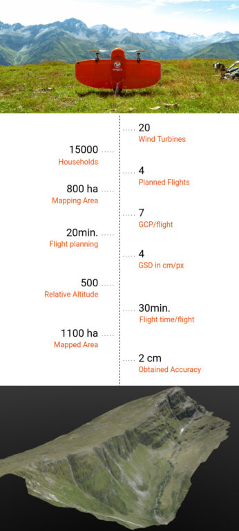
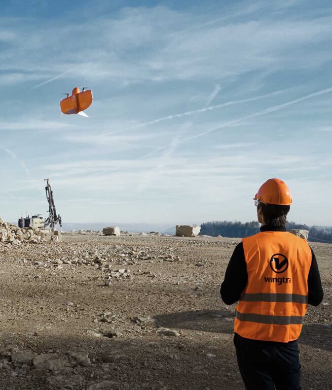
Wingtra Brings Wind Energy to the Alps
At a lofty altitude of 2500m above sea level, 20 wind turbines of 100m height are to be built. These wind turbines will produce 60 GWh per year to power 15,000 households. The challenge, however, is twofold. With the construction site in the middle of the mountains, there are no roads to access it. Nor […]

SkyWrx: Starting an Agriculture Drone Services Business
Last month, the COPTRZ team had the pleasure of catching up with a long-standing customer, Ben Storer of SkyWrx. Ben first contacted COPTRZ over 18 months ago in the initial stages of starting up his agriculture drone services business. With the help of COPTRZ, Ben’s business has gone from strength-to-strength, and he recently received a […]

Wingtra Sets New Benchmark in Drone Photogrammetry
Thinking of upgrading your current aircraft model to a WingtraOne Fixed Wing? Check out our Wingtra trade-in scheme and save up to £3,900 on a brand new drone. COPTRZ are delighted to announce the release of the new WingtraOne PPK, a new fixed wing VTOL drone that will set a new benchmark in drone photogrammetry. […]
Propeller AeroPoints – Do they work in the real world?
With the increase in drones being used as a key surveying tool, many questions are being asked about the accuracy of their GPS positioning from the sky. 3D mapping can be easily achieved with the use of a basic GPS enabled drone and processing software. However, for times when pinpoint accuracy is required, it is […]
Pix4Dmapper Version 3.3 Released
Pix4D’s rayCloud is an iconic interface that connects original images to the 3D reconstruction. Add and edit your ground control and manual tie points to improve your project accuracy without searching for each point in an endless list of images. Simply select the point’s approximate location in the point cloud and refine its position in […]

Is UAV LiDAR the Next Big Thing for Surveying?
In the world of technological innovation, there usually comes a time where an invention crosses over from cutting-edge, into the mainstream, from being a great concept, into a greater reality. UAV LiDAR is one such technology. What could be better than mobile LiDAR? Affordable airborne LiDAR, of course! The world of surveying covers such a […]


Latest From Coptrz

Survey accuracy starts before the dataset, with pilot competence

Inspection work fails commercially when pilot competence is treated lightly

DJI Matrice 400

