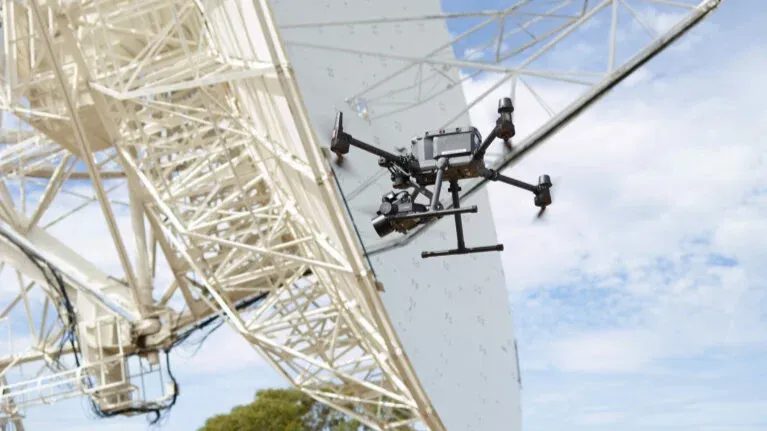
The University of Tasmania’s School of Natural Sciences set out to improve the precision of their 26-meter radio telescope at the Mount Pleasant Radio Telescope Observatory. This telescope plays a critical role in Positioning, Navigation, and Timing (PNT) research, capturing signals from distant galaxies to study Earth’s shape, rotation, plate tectonics, and timekeeping. These measurements underpin essential applications such as GPS, financial transactions, global communications, and navigation systems.
Overcoming Measurement Challenges with UAV Photogrammetry
To achieve the required accuracy, the research team needed to model and calibrate structural deformations in the telescope, which are influenced by factors like gravity. These subtle shifts can impact observational precision, making it crucial to quantify them with an accuracy better than 0.1 mm. Traditional ground-based surveying techniques proved insufficient, prompting the team to seek a more advanced solution.
Given the telescope’s large size and constantly shifting orientation, surveying its entire surface was challenging. Depending on its positioning, different gravitational deformations occurred, and some areas were inaccessible using traditional surveying methods. To tackle this, the University collaborated with UAV photogrammetry experts from Germany.
Ansgar Greiwe from Ruhr University Bochum of Applied Sciences emphasised that the most advanced drone-based imaging solution on the market was required for this project, Phase One’s P3 camera. With contributions from Michael Lösler and Cornelia Eschelbach of Frankfurt University of Applied Sciences, the team set out to analyze and assess the telescope’s structural deformations using cutting-edge aerial photogrammetry.
The Phase One P3: The Market’s Most Advanced Drone-Based Camera
To carry out the survey, the team deployed the Phase One P3, the most advanced UAV-based photogrammetry camera available today, exclusively from Coptrz. Mounted on a DJI M350 drone, the P3 enabled the research team to achieve unprecedented measurement accuracy in the most challenging conditions.
The Phase One P3 is specifically designed for photogrammetry and mapping, offering an array of high-performance features:
- Ultra-High Image Quality: The P3 delivers outstanding resolution, dynamic range, and color accuracy, even in high-reflection environments like the telescope’s white dish.
- Superior Optics: With a medium-format sensor, the P3 provides sharper imagery and greater depth of field compared to standard drone cameras.
- Fixed Integration: Unlike cameras using gimbal stabilisers, the P3’s rigid mounting ensures pinpoint accuracy in photogrammetric surveys.
- No Image Distortion: Rigorous laboratory testing confirmed the P3’s images were distortion-free, even at the edges of each frame.
- Fast and Efficient Data Capture: With a rapid capture rate, the P3 reduces total survey time by up to 50% compared to cameras with smaller sensors.
- Seamless UAV Integration: The camera integrates directly with drone systems, allowing for real-time settings adjustments mid-flight.
Precision Surveying in Action
To ensure the highest level of accuracy, around 1,000 target points were placed across the telescope’s surface as reference markers. The team conducted over 200 flights, capturing more than 300 images per flight using different lens configurations. After testing an 80mm lens, which proved to have too narrow a field of view, they selected the 35mm lens for its ability to capture a broader section of the telescope while maintaining pinpoint precision.
The P3 camera’s performance exceeded expectations, producing flawless image quality, even when capturing shots directly toward the sun. Its high dynamic range and ability to capture crisp, high-resolution images in any lighting conditions were particularly beneficial when photographing the telescope’s highly reflective surface. Furthermore, the camera’s real-time parameter adjustment capability meant the team could adapt to changing light conditions mid-flight, maximising efficiency without the need to land the UAV.
Unparalleled Efficiency and Results
The efficiency of the Phase One P3 drastically reduced the time required for data collection, allowing the research team to complete the entire project within the limited window available for telescope access. Thanks to its large sensor and rapid capture rate, the P3 enabled the team to cut survey time in half, making large-scale structural analysis feasible where other methods would have fallen short.
By leveraging the advanced technology of the Phase One P3, available exclusively from Coptrz, this research project demonstrated how UAV photogrammetry is revolutionising precision measurement. The results of this survey not only refined the telescope’s calibration but also set a new benchmark for using drone-based imaging in high-accuracy scientific research.
For professionals requiring the highest level of aerial surveying precision, the Phase One P3 is the ultimate solution.
Get in touch with Coptrz today to learn how this industry-leading camera can transform your UAV surveying capabilities.
Download Our FREE RPC-L1 Guide
Understand everything you need to know about moving towards commercial drone operations with our RPC-L1 guide.
- Understand what RPC-L1 is and who it is for
- Learn how the CAA transition impacts operators and training routes
- Get a clear breakdown of requirements, costs and next steps


Related Posts
Watch the Elios Drone Inspecting a Ballast Tank
CMA CGM required the internal inspection of a ballast tank of one of its container ships, the CMA CGM ANDROMEDA. Flying in complex and pitch-dark confined spaces, the Flyability Elios drone has demonstrated its capacity to deliver a quicker and safer method to inspect ballasts. Customer Need CMA CGM required an inspection for one of […]
Why Emesent’s Hovermap ST-X is Redefining SLAM LiDAR Mapping Accuracy in 2025
The LiDAR mapping space is no stranger to innovation, but every now and then, a technology sets a new benchmark that redefines expectations. Emesent’s latest Hovermap Accuracy Report delivers exactly that. Based on independent testing at GeoWeek 2024 and head-to-head comparisons with both SLAM and TLS systems, the Hovermap ST-X emerges not just as a […]

Furlough – Kick-Start Your Drone Career At Home
In this blog you will find out what you can do if you’ve been put on furlough: An overview of ‘furlough’ and what it means for you How you can use your time on furlough to kick-start your drone career by booking on to one of our online training courses How you can still train, […]















