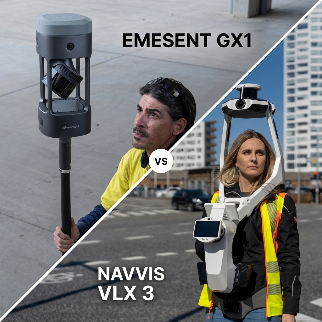
The Emesent GX1 is a 3.5 kg ground-based mobile mapping scanner featuring a long-range LiDAR sensor, integrated RTK positioning and an IP65-rated body. Designed for survey, construction and infrastructure applications, it supports multiple mounting configurations, including backpack, survey pole and vehicle-mounted setups.
The NavVis VLX 3 is an 8.5 kg wearable mobile mapping system designed for large indoor and outdoor reality-capture projects. Its two LiDAR sensors, panoramic imaging system and control-point workflow make it particularly suitable for measured building surveys, industrial facilities and digital twin creation.
Both are SLAM-based mobile mapping systems, but they serve different workflows. The GX1 prioritises flexible ground-based scanning, long-range capture and georeferencing options. The VLX 3 focuses on wearable capture, panoramic imagery and delivering accessible digital twins through the NavVis software ecosystem.
A single millimetre figure does not make them the same instrument. Accuracy, environmental conditions, control-point requirements and the final deliverable all matter when selecting a scanner.
For wider buying considerations, see what to look for in a LiDAR scanner for infrastructure and why capture quality decides a digital twin.
Emesent GX1 and NavVis VLX 3 compared
The following table compares the published specifications of both systems. Accuracy figures should be interpreted according to their individual test conditions rather than treated as directly interchangeable measurements.
| Feature | Emesent GX1 | NavVis VLX 3 |
|---|---|---|
| Form factor | Ground-based mobile scanner; backpack, supported handheld, survey pole or vehicle mounting | Wearable mobile mapping system |
| Weight | 3.5 kg with battery; 3.2 kg without | 8.5 kg with two batteries |
| LiDAR sensor | Hesai XT32M2X, 32 channels | 2 × 32-layer LiDAR sensors |
| Maximum LiDAR range | Up to 300 m | Raw range up to 300 m; operational range up to 50 m |
| Point rate | 640,000 points/s single return; up to 1.92 million points/s with triple returns | 1,280,000 points/s per sensor; 2,560,000 combined |
| Global accuracy | 5–10 mm depending on environmental features; 5–8 mm with GCP constraints; 15 mm with RTK/PPK in a specified outdoor test | Absolute accuracy depends on site size and control-point workflow |
| Local accuracy | 5 mm (3D RMSE) | 5 mm in a dedicated 500 m² test environment (1σ) |
| Scan precision | Up to 2 mm | Not directly specified as a separate comparable figure |
| Positioning and control | Integrated 448-channel RTK receiver, PPK support and GCP workflows | Ground and wall control-point workflows |
| Cameras | 4 × 20 MP; 360° horizontal × 284° vertical coverage | 4 × 20 MP fisheye cameras; stitched 360° panoramas |
| Ingress protection | IP65 | IP42 |
| Operating temperature | −10°C to +45°C | 0°C to +40°C; down to −10°C for up to 20 minutes under specified conditions |
| Battery life | Approximately 60 minutes per removable battery | Approximately 1.5 hours per two-battery set; hot-swappable |
| External power | 9–24 V input | No equivalent external operating-power input listed in the standard specification |
| Storage | 2 TB onboard, with SD card expansion | 1 TB portable SSD |
| Processing and review | Emesent Aura, Commander and Aura Cloud; on-premise processing available | NavVis IVION and IVION Processing |
| Strongest applications | Topographic survey, construction, Scan-to-BIM, roads, rail, tunnels and infrastructure | Large buildings, factories, campuses, indoor and outdoor reality capture, and digital twins |
Specifications are based on published manufacturer and supplier documentation. Maximum ranges, accuracy and endurance depend on configuration and operating conditions. The GX1’s RTK/PPK result and the VLX 3’s local accuracy result come from different test environments.
Accuracy: Read the figures the way a surveyor does
Accuracy is one of the most important considerations when comparing mobile LiDAR scanners. However, manufacturers do not always measure or report accuracy in the same way.
The Emesent GX1 publishes different global accuracy figures depending on environmental features and the positioning method used. The NavVis VLX 3 publishes a local accuracy result from a defined test environment, while explaining that absolute accuracy depends on the size of the site and the control-point workflow.
Understanding these distinctions is essential when selecting equipment for surveying and Scan-to-BIM applications.
Emesent GX1 accuracy
The Emesent GX1 publishes the following accuracy figures:
| Measurement | Published accuracy |
|---|---|
| Global accuracy, unconstrained, many features | 5 mm |
| Global accuracy, unconstrained, few features | 10 mm |
| Global accuracy with GCPs, many features | 5 mm |
| Global accuracy with GCPs, few features | 8 mm |
| Global accuracy with RTK/PPK | 15 mm |
| Local accuracy | 5 mm |
| Scan precision | Up to 2 mm |
These results demonstrate how the surrounding environment and positioning method can influence the final point cloud.
In environments with plenty of structural features, SLAM can use visible geometry to maintain positioning. Sparse or repetitive environments can make this more challenging, which is why ground control points and suitable positioning methods remain important.
The GX1 also integrates a 448-channel RTK receiver. Its receiver-level specifications are 0.6 cm + 0.5 ppm horizontal and 1 cm + 0.5 ppm vertical.
These figures describe the GNSS receiver’s positioning performance, not the overall accuracy of the completed SLAM point cloud.
For an outdoor project using RTK or PPK, the published 15 mm global accuracy result was measured against a local base station with a baseline under 1 km. Actual results will depend on the quality of GNSS reception, correction data and survey conditions.
NavVis VLX 3 accuracy
The NavVis VLX 3 publishes 5 mm local accuracy, measured in a dedicated 500 m² test environment using a 1σ convention.
For larger sites, absolute accuracy depends on the environment and the control-point workflow. NavVis supports ground and wall control points to help constrain and georeference the captured data.
This makes control planning an important part of a NavVis survey, particularly where the final model needs to align with existing building information, architectural drawings or other survey datasets.
Which scanner is more accurate?
It would be misleading to declare one scanner more accurate based only on the published 5 mm figures.
The GX1’s local accuracy and the VLX 3’s local accuracy are not necessarily measured under identical conditions. Similarly, the GX1’s global accuracy and RTK/PPK results answer different questions from the VLX 3’s local test result.
For a Scan-to-BIM project, request a sample dataset captured and registered using the same control strategy intended for the actual site. Compare the resulting point cloud against independent survey control and the project’s required tolerances.
Our comparison of the Emesent GX1 and traditional laser scanning explores how mobile mapping fits into established surveying workflows.
Range, environmental protection and how each scanner is carried
The physical design of a mobile scanner affects where it can be used, how quickly it can be deployed and how much ground a survey team can cover.
The Emesent GX1 and NavVis VLX 3 take noticeably different approaches.
Emesent GX1: Flexible ground-based scanning
The Emesent GX1 uses a Hesai XT32M2X 32-channel LiDAR sensor with a published maximum range of up to 300 m.
This long-range capability can be valuable when capturing large structures, infrastructure corridors, stockpiles and industrial environments. Actual usable range depends on surface reflectivity, environmental conditions and the required point-cloud quality.
At approximately 3.5 kg with its battery, the GX1 supports several mounting configurations, including:
- Backpack mounting.
- Supported handheld operation.
- Survey pole mounting.
- Vehicle mounting.
This flexibility allows surveyors to adapt the scanner to the environment rather than being limited to one walking configuration.
The GX1 also has an IP65 ingress-protection rating and an operating temperature range of −10°C to +45°C.
Its removable battery provides approximately 60 minutes of operation. For longer vehicle-based capture sessions, the scanner supports an external 9–24 V power input.
These characteristics make the GX1 suitable for projects where the survey team needs to move between different types of terrain, structures and infrastructure.
For rail and highway work, this flexibility can be particularly valuable when survey access is restricted by short possession or closure windows. See mobile mapping for rail and highways.
NavVis VLX 3: Wearable scanning for large environments
The NavVis VLX 3 is designed to be worn by an operator, allowing continuous data capture while walking through a site.
Its two 32-layer LiDAR sensors have a published raw range of up to 300 m, although its stated operational range is up to 50 m.
This distinction is important: the maximum sensor range should not be confused with the distance at which the system is intended to deliver its normal operational results.
The wearable configuration is particularly suitable for large buildings, industrial facilities and campuses where operators need to capture connected spaces efficiently.
The VLX 3 weighs approximately 8.5 kg with two batteries and offers around 1.5 hours of operation per battery pair. Its batteries are hot-swappable, allowing operators to continue working by replacing the battery set during longer capture sessions.
Its IP42 rating and standard operating temperature range of 0°C to +40°C should also be considered when planning outdoor work.
NavVis documents limited operation down to −10°C for up to 20 minutes under specific conditions. This requires the device to be switched on for 20 minutes at a temperature of at least 0°C beforehand, with calm conditions and no wind.
The VLX 3 can support outdoor reality capture, but it should not be treated as a substitute for a scanner designed for harsher weather and environmental conditions.
Camera systems and the final deliverable
LiDAR point clouds provide the spatial information used to create accurate digital representations of environments. However, imagery can make those datasets considerably more useful.
Both scanners feature four 20 MP cameras, but their image coverage and software workflows are different.
Emesent GX1: Panoramic imagery and point-cloud colourisation
The Emesent GX1 includes four 20 MP cameras providing 360° horizontal and 284° vertical image coverage.
Its panoramic imagery can be used to colourise point clouds and provide visual context for captured environments.
Emesent publishes ground sample distance figures of approximately:
- 0.96 mm per pixel at 1 m.
- 4.8 mm per pixel at 5 m.
The GX1’s imagery complements its LiDAR data, helping surveyors interpret structures and identify details within the captured point cloud.
Its software ecosystem supports processing and exporting data for use in established surveying and design applications.
Aura supports colourisation and panorama integration, with export formats including E57, LAS, LAZ, PLY and DXF. These formats support workflows involving software such as Revit, AutoCAD, Navisworks, Cyclone and MicroStation.
Emesent also offers on-premise processing, which can be valuable for organisations that need to retain sensitive project data within their own infrastructure.
For more information about the scanner’s capabilities, see the Emesent GX1 product article.
NavVis VLX 3: Full-sphere imagery for digital twins
The NavVis VLX 3 also uses four 20 MP fisheye cameras, producing stitched 360° panoramic imagery.
The camera arrangement is designed to keep the operator outside the resulting panorama, making the imagery suitable for browsing and presenting captured spaces.
This is particularly valuable for organisations creating digital twins of buildings and facilities.
A user can explore the captured environment through panoramic imagery, understand the surrounding layout and access spatial information without physically returning to the site.
The NavVis software ecosystem adds further value through IVION, which supports digital twin viewing, sharing, measurements and collaboration.
Privacy features include automatic blurring of people and licence plates, helping organisations manage identifiable information captured during site surveys.
NavVis offers different hosting and enterprise deployment arrangements, so organisations handling sensitive project information should confirm the applicable data-storage location, processing arrangements and access controls.
For building surveyors, facilities managers and industrial operators, the combination of panoramic imagery and an accessible digital twin can make the VLX 3 particularly attractive.
Processing software and data management
The scanner itself is only one part of a mobile mapping workflow. Processing, reviewing, exporting and sharing the resulting datasets can have an equally significant impact on project efficiency.
Emesent GX1: Aura and on-premise processing
The Emesent GX1 works within the Emesent software ecosystem.
Its main tools include:
- Commander: Supports field scanning and monitoring workflows.
- Aura: Provides point-cloud processing, visualisation and data management.
- Aura Cloud: Supports sharing and walkthrough-style visualisation.
Aura can colourise point clouds, integrate panoramic imagery and export data into formats used by established CAD, BIM and surveying software.
Emesent also promotes unlimited on-premise processing without per-scan charges, which can be attractive to organisations processing large quantities of survey data.
For companies with strict information-security requirements, the ability to process data on their own infrastructure can be an important purchasing consideration.
NavVis VLX 3: IVION and digital twin workflows
The NavVis VLX 3 is designed to work with the NavVis software ecosystem, particularly IVION.
NavVis IVION provides a platform for viewing, sharing and working with captured reality data.
Users can navigate panoramic imagery, view point clouds, take measurements and collaborate around the captured environment.
IVION Processing supports the processing of captured datasets into usable digital twin information.
The platform also offers privacy-related features, including automatic blurring of people and licence plates.
NavVis provides different hosting and enterprise arrangements. Buyers should confirm the available deployment model, hosting region, data-retention policies and contractual data-protection requirements before selecting a solution.
For organisations that need to make captured environments accessible to project stakeholders, facilities teams and other departments, the IVION ecosystem is an important part of the VLX 3’s value.
Where each scanner earns its place
Both systems are designed to make spatial data capture more efficient, but the best choice depends on the environment and the type of information the project needs to produce.
Emesent GX1: Surveying, construction and infrastructure
The Emesent GX1 is well suited to projects where long-range LiDAR, flexible mounting and georeferencing are important.
Typical applications include:
- Topographic and land surveying.
- Construction progress monitoring.
- Scan-to-BIM and as-built documentation.
- Road and rail infrastructure.
- Tunnels and underground environments.
- Industrial facilities and large structures.
- Stockpile and site measurements.
Its integrated RTK receiver and PPK support make it particularly useful for outdoor projects where georeferencing is required and suitable GNSS reception is available.
For environments where satellite positioning is unreliable, SLAM and control-point workflows remain important. RTK alone does not eliminate the need to plan for GNSS-denied sections or poor-feature environments.
The GX1’s multiple mounting options also allow teams to adapt their scanning approach to different environments, including vehicle-based and pole-mounted capture.
It is important to distinguish the GX1 from Emesent’s aerial scanning solutions. The GX1 is a ground-based mobile mapping scanner, not a drone payload.
For aerial and autonomous scanning, the Emesent Hovermap is the relevant product. An independent tunnel comparison is available in Hovermap ST-X and traditional TLS.
NavVis VLX 3: Buildings, factories and digital twins
The NavVis VLX 3 is particularly suited to environments where an operator can walk through connected spaces and capture large amounts of spatial and visual information.
Typical applications include:
- Measured building surveys.
- Large commercial properties.
- Industrial facilities and factories.
- Universities and campuses.
- Facilities management.
- Scan-to-BIM.
- Indoor and outdoor digital twins.
- Asset documentation and site visualisation.
Its wearable design supports continuous capture across floors, corridors and connected spaces.
The full-sphere imagery and NavVis IVION platform also make it attractive to organisations that need to share captured environments with stakeholders who may not have specialist surveying software.
For these projects, the final deliverable is not simply a point cloud. It is an accessible digital representation of the building or facility.
Can both scanners be used in the same surveying workflow?
Yes. In some organisations, the Emesent GX1 and NavVis VLX 3 could complement each other rather than compete directly.
For example, a large industrial estate may require both indoor and outdoor scanning.
The NavVis VLX 3 could be used to capture offices, production buildings, warehouses and connected internal spaces. Its panoramic imagery and IVION integration would make the resulting data accessible to facilities managers and other stakeholders.
The Emesent GX1 could then be used for external infrastructure, road networks, yards, tunnels and other areas where its long-range sensor, RTK positioning and flexible mounting options are useful.
A static terrestrial laser scanner may still be retained for specific locations requiring a tripod-based workflow or additional detail.
The important consideration is choosing the right capture method for each part of the project, rather than forcing one scanner to perform every task.
UK survey practice, project planning and training
For UK survey teams, access restrictions, project deadlines and the cost of returning to a site can all influence the choice of mobile mapping equipment.
Rail possessions and highway closures reward equipment that can capture the required information within a limited access window.
The Emesent GX1’s flexible mounting options, RTK capability and long-range LiDAR sensor can be valuable for these types of projects.
Indoor measured-building surveys have different priorities. Complete coverage, reliable control, panoramic imagery and efficient sharing can be more important than maximum sensor range.
The NavVis VLX 3 is designed around this type of workflow.
Before purchasing either scanner, build an ROI case around your own project requirements. Consider:
- Current survey time and labour costs.
- The number of sites captured each month.
- The cost of revisiting incomplete areas.
- Required accuracy and control-point density.
- Processing and software licensing costs.
- Staff training and onboarding.
- Data storage and security requirements.
- The number of projects that can be completed within a given period.
The worked approach is explained in how to build an ROI case for mobile mapping equipment, while Turn days of scanning into hours explores the potential time savings from mobile scanning.
Coptrz Academy’s LiDAR survey course covers how LiDAR fits into surveying, photogrammetry and infrastructure applications.
Coptrz can also provide product demonstrations, onboarding and implementation support for organisations considering the Emesent GX1.
If a newer NavVis generation is also being considered, its current specification should be compared against the VLX 3 before making a final purchasing decision.
Frequently Asked Questions
Can the Emesent GX1 replace a terrestrial laser scanner?
The Emesent GX1 can replace or reduce the need for conventional tripod-based scanning across many mobile surveying applications.
Its SLAM-based capture can cover large environments efficiently, with published global accuracy figures of 5–10 mm depending on environmental features and the selected control method.
However, it will not replace every terrestrial laser scanning workflow. Projects requiring specific static scanning setups, detailed individual measurements or particular survey tolerances may still benefit from a conventional terrestrial laser scanner.
The appropriate choice depends on the required accuracy, site conditions and final deliverable.
Are the Emesent GX1 and NavVis VLX 3 accuracy figures comparable?
Not directly.
Both systems publish 5 mm local accuracy figures, but their test environments and measurement conditions are different.
The GX1 also publishes global accuracy and RTK/PPK performance figures, while NavVis explains that absolute accuracy depends on site size and control-point workflows.
For a meaningful comparison, request sample datasets and assess them against independent control using the same registration and validation process.
Which scanner is better for indoor surveying?
The NavVis VLX 3 is particularly well suited to large indoor measured-building surveys where continuous wearable capture, panoramic imagery and digital twin workflows are important.
The Emesent GX1 can also be used indoors, particularly in industrial environments, tunnels and complex structures where its mounting flexibility and long-range LiDAR are useful.
The best option depends on the type of environment and whether the project prioritises a walkable capture workflow or more flexible ground-based scanning.
Which scanner is better for outdoor surveying?
The Emesent GX1 is generally the stronger option for outdoor surveying applications that benefit from integrated RTK/PPK, flexible mounting and its IP65-rated design.
The NavVis VLX 3 can also capture outdoor environments, but its IP42 rating and operating-temperature limitations should be considered when planning work in challenging weather.
Does the Emesent GX1 support RTK and PPK?
Yes. The Emesent GX1 includes an integrated 448-channel RTK receiver and supports RTK and PPK positioning workflows.
These capabilities can improve georeferencing when suitable GNSS reception and correction data are available.
However, the receiver’s positioning accuracy should not be confused with the accuracy of the final SLAM point cloud. Ground control and independent survey validation remain important for projects with strict accuracy requirements.
Can the NavVis VLX 3 create digital twins?
Yes. The NavVis VLX 3 is designed for reality capture workflows that can be processed and accessed through NavVis IVION.
Its LiDAR data and panoramic imagery help create navigable digital representations of buildings and facilities.
Users can view captured environments, access measurements and share spatial information with project stakeholders.
Is the Emesent GX1 a drone-mounted LiDAR scanner?
No. The Emesent GX1 is a ground-based mobile mapping scanner.
For aerial and autonomous LiDAR capture, Emesent offers the Hovermap product range, which can be integrated with supported drones and other platforms.
Discuss the Emesent GX1 with Coptrz
Choosing a mobile LiDAR scanner involves more than comparing maximum range, point rate and published accuracy.
The Emesent GX1 is a flexible ground-based mapping system designed for surveying, construction and infrastructure applications where long-range capture, RTK/PPK and multiple mounting options are valuable.
The NavVis VLX 3 is a wearable reality-capture system designed for large buildings, factories and campuses where panoramic imagery, walkable scanning and digital twin workflows are important.
The right choice depends on your survey environment, accuracy requirements, available control, processing workflow and the deliverables your clients expect.
Request the Emesent GX1 information pack for a detailed overview of its sensor specifications and capabilities.
To discuss your survey requirements, arrange a demonstration or compare the Emesent GX1 with the NavVis VLX 3, contact our team or call 0330 111 7177 for a tailored UK quotation.
Download Our FREE RPC-L1 Guide
Understand everything you need to know about moving towards commercial drone operations with our RPC-L1 guide.
- Understand what RPC-L1 is and who it is for
- Learn how the CAA transition impacts operators and training routes
- Get a clear breakdown of requirements, costs and next steps

Related Posts
Watch the Elios Drone Inspecting a Ballast Tank
CMA CGM required the internal inspection of a ballast tank of one of its container ships, the CMA CGM ANDROMEDA. Flying in complex and pitch-dark confined spaces, the Flyability Elios drone has demonstrated its capacity to deliver a quicker and safer method to inspect ballasts. Customer Need CMA CGM required an inspection for one of […]
New CAA Proposal Could Finally Allow Drone Deliveries
The Civil Aviation Authority (CAA) is initiating a bold move to reform drone operation regulations to expand drone operation beyond visual line of sight (BVLOS), especially near buildings or infrastructure. This significant step aims to enhance the utility of drones in various sectors, including delivering medicines and inspecting vital infrastructure. The initiative, part of the […]
A2 CofC in 2026: Greater Freedom for Qualified Drone Pilots
From 1 January 2026, the UK Civil Aviation Authority (CAA) will implement significant regulatory changes to the Open Category, including new class markings and the integration of Remote ID requirements. For holders of the A2 Certificate of Competency (A2 CofC), these changes are particularly positive offering expanded operational privileges without the need for additional training […]