
Latest from Coptrz
Stay updated with the latest insights, tips, and industry news on our blog. Discover expert advice, success stories, and innovative uses of drone technology. Our blog features a diverse range of topics to keep you informed and inspired.
All Posts
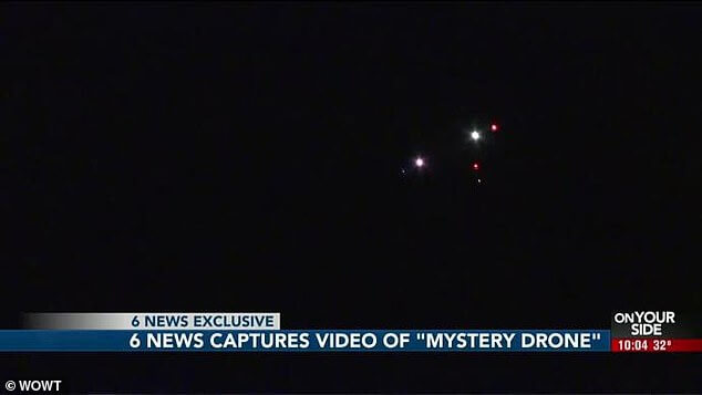
It’s a bird! It’s a plane! It’s a UFO?
When you think about it, UFO sightings used to be all the rage before the invention of drones and mobile phones. Now, with everyone carrying a camera in their pocket those stories have all but disappeared. And it’s with that thought in mind that we look at not only this great mystery, but others that […]
Drones for Surveying: Arcadis
Arcadis – Civil Engineering At Coptrz, we know that challenging terrain comes with the territory of surveying, and more often than not access and measuring points are difficult to reach and require time heavy and meticulous planning and operations. Let’s take a look at a case study using drones for surveying… The recent introduction of […]

Thermal Imaging Technology – Industry Insights from FLIR
Wondering where to start with Thermal Imaging Technology? We’re here to help Teledyne FLIR designs, develops, manufactures, markets, and distributes technologies that enhance perception and awareness. They bring innovative sensing solutions into daily life through our thermal imaging, visible-light imaging, video analytics, measurement and diagnostic, and advanced threat detection systems. With all of the different […]

Coptrz Partner with Lorenz Technology
We recently announced our new partnership with Lorenz Technology to provide automated drone solutions in the UK for security and first responders. As the UK’s leading commercial drone experts, this is an exciting partnership as Coptrz will become the official seller of Lorenz Technology in the UK. What Products do Lorenz Technology Offer? Based in […]

Micasense RedEdge vs Parrot Sequoia
Multispectral imaging camera sensors on agricultural drones allow the farmer to manage crops, soil, fertilizing and irrigation more effectively. Both the MicaSense RedEdge and Parrot Sequioa are incredible pieces of kit – but what are the differences between them? In this blog we simplify both, allowing you to make the right decision. We have recently […]
How are Drones Used In Surveying?
5-10 minute read The use of drones in the survey and construction sectors has come a long way and the capabilities of those very drones has seriously improved, making them an essential tool that all surveyors should have in their toolbox. Your choice of sensors, surveying software and drone can have a huge impact on […]

5 Times UK Police Used Drones For Good
Image: Iain Brown|Daily Record Drones are now playing an instrumental role in a large proportion of police operations. From being used to find missing persons, to locating a suspect, to providing a watchdog above for boots on the ground officers, drones are now a vital piece of kit for police in the UK. In a […]
DJI’S first LiDAR Solution – Zenmuse L1
5 – 10 minute read What is the Zenmuse L1? In aerial surveying, LiDAR technology is increasingly playing a larger role in building accurate models. In October of 2020, DJI announced the Zenmuse L1, their first foray into a fully integrated LiDAR Drone solution for aerial surveying. DJI noticed the opportunity of a LiDAR based […]

How Drones Aid Search & Rescue
An Introduction to Drones In Search & Rescue A person is reported missing every 90 seconds in the United Kingdom, with more than 353,000 reported missing incidents every year. Working alongside the police to tackle this epidemic are 49 volunteer organisations across the UK, each covering various terrains and landscapes. Conventional search and rescue methods […]
Growth of the Drone Industry with Rebecca Jones
The growth of the Drone Industry: By Rebecca Jones Established in 2014, regarded as a pivotal company in the promotion and implementation of many of the UAV survey applications which we see within varied markets, Iprosurv are an optimum quality UK drone pilot contractor network comprising of field experts who strive to provide clients, from […]

Drones in Surveying – How When & Why?
The Drones in Surveying Summit 2021 Aerial photogrammetry and surveying are not a new combination, manned aircraft have long been the reliable yet expensive choice for surveyors in the collation of big data sets across large areas. Yet the media coverage and advancements in technologies like battery capacity have brought drones into the spotlight for […]

Drones For Livestock Management – Drones For Good
Drones For Livestock Management – Drones For Good Whatever the size of herd or the pastures upon which they graze, monitoring and moving stock on the farm can be effectively carried out by drones. Drones For livestock management is the next logical step in agricultural technology. In this article you will learn; Livestock management at […]


