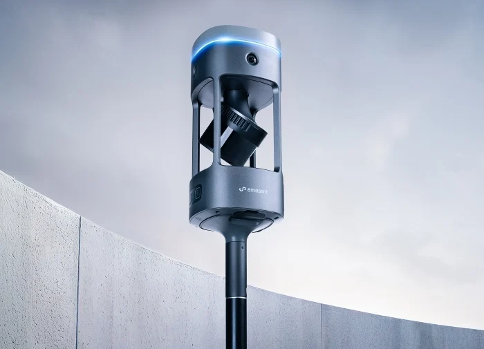
We’re thrilled to spotlight the latest update of a leading-edge tool that transforms professional environments—PIX4Dcatch 2.0. This free app now comes packed with new AR features and RTK support for precision in surveying and construction.
What Sets PIX4Dcatch 2.0 Apart?
With the app, professionals can easily overlay AR georeferenced DXF, IFC, or 3D models directly onto construction sites in real time. Moreover, this tool can visualise underground pipes post-trench closure, a game-changer for subsurface utility management. This powerful functionality ensures ongoing construction projects align perfectly with CAD designs, enhancing accuracy while cutting costs.
Advanced Features and RTK Compatibility
PIX4Dcatch 2.0 introduces expanded compatibility with RTK GNSS rovers such as the EMLID Reach RX, Trimble Catalyst DA2, and the upcoming BadElf Flex, in addition to the Pix4D-adapted viDoc RTK rover. This ensures that users can achieve sub-centimetre accuracy, enhancing efficiency in data collection across various project needs.

New Licensing Options
PIX4Dcatch 2.0 is now available in three subscription models—Discovery, Standard, and Professional. The Discovery tier offers basic GPS 3D scanning capabilities, perfect for casual or initial project assessments. The Standard license broadens project scope by enabling data export and project sharing via PIX4Dcloud. The Professional license unlocks full capabilities, including RTK support and AR features for unmatched precision in your projects.

Pix4D Autotags™
Pix4D has launched Pix4D Autotags™, robust tags made from aluminium and PVC, to optimise the precision and efficiency of surveying workflows using PIX4Dcatch 2.0. These tags, which support the app’s Tag Detection feature, are available for purchase in quantities up to 50, helping streamline point collection and enhance survey accuracy and speed.

Applications
Subsurface Utility Mapping
Pix4Dcatch can quickly scan open trenches and, after they’re closed, use AR to view subsurface utilities’ positions. The tool can also annotate and precisely measure volumes, areas, and distances. This speeds up project management, saving both time and costs.
Construction
PIX4Dcatch changes how CAD designs are viewed in real environments. It displays DXF and IFC files over actual construction sites. This enables accurate on-site measurements and project verifications and simplifies data uploads to PIX4Dcloud for improved team collaboration and project tracking.
Forensics
PIX4Dcatch makes it easy to capture crime scenes and reconstruct accidents. With Pix4D, data from drones and phones can be merged to create detailed 3D models. This technology simplifies the process of documenting and analysing incidents. The detailed models provide a comprehensive view of the scene.
Surveying
PIX4Dcatch merges terrestrial and drone imagery to create detailed 3D models, replacing traditional tools like laser scanners. Connected with RTK, it enhances the accuracy of data collection and simplifies the surveying process. This makes an efficient solution for collecting ground control points and achieving high precision.
At Coptrz, we have empowered hundreds of businesses to reach new heights of operational efficiency and precision. Whether you are exploring the potential of drone technology for the first time or looking to enhance your existing systems, our experts are here to guide you every step of the way. We offer comprehensive support encompassing hardware, software, training, repairs, and consultancy, all tailored to meet your unique business needs.
AR Points
Processed Output
Download Our FREE RPC-L1 Guide
Understand everything you need to know about moving towards commercial drone operations with our RPC-L1 guide.
- Understand what RPC-L1 is and who it is for
- Learn how the CAA transition impacts operators and training routes
- Get a clear breakdown of requirements, costs and next steps


Related Posts

Flying your Drone In Winter: Our Drone Survival Guide
COPTRZ Top 5 Tips for Flying in Winter – Your very own Drone Survival Guide Flying drones during the winter months can be an extremely challenging experience. It can test even the best pilots, so it’s important to follow these simple guidelines to maintain the condition of your drone. This survival guide intends on taking […]

How Leicestershire Search and Rescue are Using Drone Technology
Drones are being used to save lives across the UK. From accessing confined spaces with the likes of the Flyability Elios to covering vast areas of land using the DJI Matrice 300 RTK. Police forces, fire services and search & rescue organisations alike are making a difference using new and innovative technology. One of the […]

COPTRZ Emergency Services Drone Demo Day
Here at COPTRZ we hosted a fantastic drone demo day down at the Norfolk Showground with the emergency services. On show were a number of the superb products that we have available in our store. This included the impressive Aeroscope drone detection unit. There were also demos for the Flyability Elios and DJI’s Matrice 210. […]