Agriculture & Forestry
Drones are revolutionising the way we approach agriculture and forestry. From providing multispectral insights on crops to providing birds-eye view of forests to spraying greenhouses, agricultural drones are innovative tools to carry out precise data collection and resource management.
- Enhanced Efficiency
- Improved Safety
- Cost Savings
Get your FREE guide
Drones are revolutionising the way we approach agriculture and forestry.

Data driven
agriculture
Agriculture drones revolutionise crop health monitoring, spraying and seed spreading along with many other tasks to improve farming efficiency.

Enhanced Efficiency
Agriculture drones can perform tasks faster and more efficiently than traditional methods, reducing labour costs and increasing productivity. They are particularly valuable for data collection, surveillance, and inspections in various industries.

Cost Savings
Drones reduce operational expenses, such as labour and equipment costs, and can extend the lifespan of expensive assets by enabling proactive maintenance and monitoring.

Improved Safety
Drones can access hazardous or hard-to-reach areas, reducing the need for human workers to be exposed to dangerous environments.

Data Collection
Drones equipped with various sensors and cameras can capture high-quality data from the air. This data can be used for detailed mapping, environmental monitoring, agricultural analysis, and more. Advanced analytics and machine learning can then extract valuable insights from this data, aiding decision-making and problem-solving.
Cutting Edge Technology
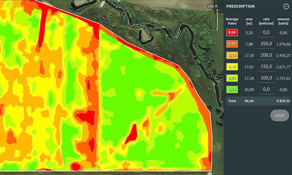
Generate Prescription Maps
Using drones equipped with multispectral imaging, farmers can gather valuable data for rice fertilization, cotton growth regulation, and potato foliar fertilizer application. Specialized software, like DJI Terra or the DJI SmartFarm Platform, processes this data to create vegetation index maps. These maps guide agricultural drones to apply variable-rate treatments, resulting in cost savings, improved yields, and environmental benefits.

DJI SmartFarm
The DJI SmartFarm App offers comprehensive support for spraying and spreading tasks, covering data presentation, device administration, field sharing, tutorials, team collaboration, measurement tools, and more. With this application, you can easily and efficiently oversee and control your Agras drones while accessing clear data.

Manage Fields
Together with DJI Terra or DJI SmartFarm Platform, you can reconstruct high-resolution orchard maps, automatically identify the number of trees, distinguish trees from other obstacles or objects, and generate three-dimensional operation routes for agricultural drones, making operations safer and more efficient.
FAQs
Drones are being adopted more in agriculture and farming due to the high volume of analysis they can do in a relatively short amount of time. To be able to survey a field, estimate crop yield, or keep track of your livestock, means farmers can be more efficient.
- Allows every inch of every field to be surveyed
- Greatly reduce the time spent field-walking
- High resolution, aerial view of the field allows you to zoom in to areas of interest without losing clarity – useful for immediate identification and GPS tagging of:
- Weed population
- Poor crop emergence
- Pest damage
- Weather damage
- Standing water
- Use of multispectral sensing technology allows earlier identification of potential crop issues
- Export processed drone data in a range of file formats for direct integration with existing ag software tools
- Availability of RTK drone solution for even greater data accuracy and collaboration with current systems
- Carry out accurate counts of grazing animals
There are a number of different options for drones that integrate with MicaSense sensors. As a general rule, if the drone can carry the weight of the sensor (~230g for RedEdge-MX and ~508.8g for the Dual Camera Solution) and can supply appropriate power to the camera then it will work to carry the sensor. MicaSense provides integration kits for commonly used DJI drones, such as the Inspire 1 & 2, Matrice 300 and 210. MicaSense also has a number of integration partners who provide specialised aircraft with MicaSense sensors integrated.
Book your FREE online consultation
Experience the unique advantage of our 360° drone solutions exclusively at Coptrz. With a network of over 20 partnerships with top-tier drone technology manufacturers, we're uniquely positioned to provide a tailored solution that you won't find elsewhere.
Impartial Expertise for
Commercial Drone Integration
End-to-end Drone Solutions
Complete drone solutions, including hardware, software, pilot training, repairs and support.
Impartial Advice
Industry experts work closely with you to find the best solution for your organisation.
UK's Widest Drone Selection
We're not limited to one brand, we offer the UK's widest range of world-renowned suppliers.


Latest From Coptrz
How Mobile Mapping Can Improve Scan-to-BIM and Measured Building Surveys
Emesent GX1 vs Traditional Laser Scanning: Speed, Accuracy and Workflow

DJI Matrice 400
