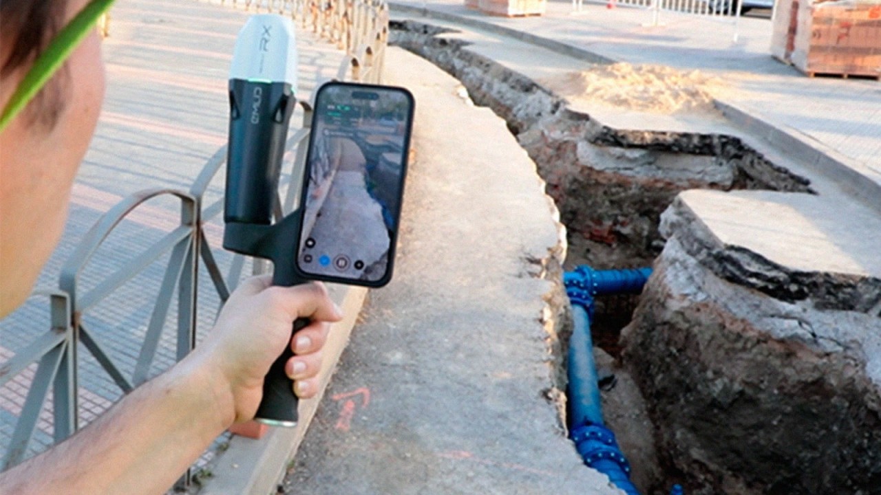
In the realm of utility management, accurately documenting underground infrastructures has always been a complex challenge. Traditional methods often fall short, leading to data gaps and incomplete visualizations. Enter Pix4D Gaussian splatting—a groundbreaking technique that’s redefining how we capture and visualise subterranean utilities.
The Limitations of Conventional Methods
Historically, surveying underground utilities involved hiring land surveyors to measure pipe locations during open trench periods. This approach is fraught with challenges: scheduling delays, safety restrictions preventing surveyors from entering trenches, and reliance on approximations rather than exact measurements. Moreover, aerial data collection, once seen as a solution, often encounters obstacles like restricted airspace and towering structures, resulting in incomplete data.
Ground-Level Data Capture: A Game Changer
The complexities of urban environments necessitate a shift from traditional photogrammetry. Deep trenches and crowded streets make image capture difficult, leading to inconsistent 3D outputs. This is where Gaussian splatting comes into play. By transforming raw scans into hyper-detailed, photorealistic 3D models, it offers utility engineers unparalleled visualisations of trench conditions and underground utilities.
Smartphone Scanning Meets Advanced Processing
Tools like PIX4Dcatch have revolutionised data capture by enabling professionals to use smartphones or tablets for ground-level scanning. When combined with Gaussian splatting, these scans are converted into comprehensive 3D models, free from the gaps and inconsistencies typical of traditional methods. This integration ensures that pipes, conduits, soil conditions, and surrounding structures are documented with exceptional clarity.
Precision Through Geo-referencing
Beyond visual richness, Gaussian splatting ensures that reconstructed models align accurately with real-world coordinates. It’s fully compatible with Real-Time Kinematic (RTK) positioning systems, enhancing the reliability of trench documentation. This compatibility guarantees that utility placements are recorded with centimeter-level precision, crucial in densely populated areas where multiple utilities intersect.
Cloud Processing: Efficiency and Accessibility
Processing data into detailed Gaussian splatting models is streamlined through platforms like PIX4Dcloud. This cloud-based approach eliminates the need for high-performance local hardware, allowing utility professionals to quickly transform captured images into detailed 3D reconstructions. The accessibility of cloud processing ensures that field teams and stakeholders can view, analyse, and share results from anywhere, fostering better collaboration and decision-making.
Enhanced Point Clouds for Comprehensive Analysis
A standout feature of Gaussian splatting is its ability to produce exceptionally dense and continuous point clouds. This means that even the smallest details—pipes, conduits, soil layers—are captured with striking clarity. For utility applications, this translates to more accurate trench documentation, improved verification of underground installations, and enhanced integration with GIS and CAD systems.
Conclusion
Gaussian splatting is not just an advancement in 3D modelling—it’s a transformative approach to mapping, verifying, and managing underground utilities. By integrating this technique with modern tools and cloud processing, utility professionals can achieve new levels of accuracy and efficiency in their projects.
Download Our FREE RPC-L1 Guide
Understand everything you need to know about moving towards commercial drone operations with our RPC-L1 guide.
- Understand what RPC-L1 is and who it is for
- Learn how the CAA transition impacts operators and training routes
- Get a clear breakdown of requirements, costs and next steps


Related Posts
Why Emesent’s Hovermap ST-X is Redefining SLAM LiDAR Mapping Accuracy in 2025
The LiDAR mapping space is no stranger to innovation, but every now and then, a technology sets a new benchmark that redefines expectations. Emesent’s latest Hovermap Accuracy Report delivers exactly that. Based on independent testing at GeoWeek 2024 and head-to-head comparisons with both SLAM and TLS systems, the Hovermap ST-X emerges not just as a […]
Permission for Commercial Operations (PfCO): The Benefits
The fact that you’re reading this means you are more than likely thinking about acquiring your PfCO (permission for commercial operations), so you are already on the right track to becoming a commercial drone pilot. In this article, we’ll detail the benefits you can expect once you’ve attained your PfCO and how you can reap […]

Using Drones for Good, Part 1: Saving Our Oceans
Drones often make the news for all the wrong reasons. Whether it’s the reckless flying into no-fly zones, the spying on neighbours or the potential assassination of a president. Whenever we turn on the news, it seems drones are up to no good. But these news stories always focus on the outlier events. Rarely do […]















