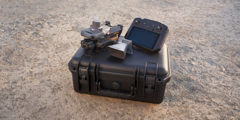
DJI has today revealed the Mavic 2 Enterprise Dual, a portable industrial drone that has been equipped with powerful, side-by-side visual and thermal cameras that provide commercial pilots with a reliable tool to operate better, safer and quicker in challenging environments.
The Mavic 2 Enterprise Dual has been developed in partnership with FLIR systems. Previously DJI and FLIR collaborated on the Zenmuse XT and XT2, and have now delivered this impressive new model. The Mavic 2 Enterprise Dual features the same array of advanced controls and accessories found in the Mavic 2 Enterprise. It also allows users to measure temperature and conveniently store images and temperature data for efficient reporting and analysis. Thus, adding immediate value to a range of industrial or time-sensitive operations today from utility inspections to emergency responses.
Powerful and Portable FLIR Thermal Imaging
The Mavic 2 Enterprise Dual features a three-axis gimbal stabilized camera housing a side-by-side 4K sensor, allowing users to capture visible light and a FLIR Lepton® thermal microcamera for capturing thermal data. Together these sensors allow pilots to perform flights at night, as well as fly in complex daytime conditions like fog and smoke. Users can select from multiple intelligent display modes in the DJI Pilot flight control app to visualize data from the dual-sensor camera:
FLIR MSX® – FLIR’s patented MSX, or multispectral dynamic imaging, embosses high-fidelity, visible light details onto the thermal imagery in real time to enhance visual details, helping pilots quickly identify and interpret critical data that may not be immediately visible to the naked eye.
Spot Meter – Displays the average temperature of an object, helping pilots monitor and measure critical or hazardous objects while maintaining a safe distance.
Area Measurement – Displays the average, lowest, and highest temperature, as well as the corresponding locations of each area, allowing inspectors to quickly assess objects and determine if an asset may be overheating.
Isotherm – This allows pilots to designate specific temperature ranges to be displayed using a custom colour palette so objects within the range relay higher contrast and better visibility. This feature includes custom profiles to aid search and rescue pilots in identifying people and to help firefighters identify hot spots in fires, as well as a custom profile setting for added flexibility.
Mavic 2 Enterprise Dual includes the same features as Mavic 2 Enterprise to protect the integrity of photos, videos, flight logs and other data generated during sensitive flights. It incorporates 24 GB of onboard data storage and password protection, creating accountability for all access to the drone’s functions and stored data. When Password Protection is enabled, users are required to enter their password each time they activate the drone, link the remote controller with the drone, and access the drone’s onboard storage, giving them full, exclusive use and enhanced security. This provides secure access to the drone and its onboard data storage while protecting that data even if the drone is physically compromised.
In addition, a GPS timestamping feature encodes the time, date, and location of every recorded image taken by the visual camera, aiding in pilot accountability and ensuring that data captured by the drone can be trusted and used in situations from reviewing critical infrastructure inspections to potential legal proceedings.
Mavic 2 Enterprise Dual users with heightened data security concerns can use the Local Data Mode feature in the DJI Pilot App which, when activated, will stop the user’s connected mobile device from sending or receiving any data over the internet. This provides added security assurances for operators of flights involving critical infrastructure, governmental projects or other sensitive missions.
Improving Flight and Airspace Safety
Every Mavic 2 Enterprise Dual comes equipped with DJI’s AirSense technology to help ensure drones remain a safe addition to the skies. AirSense improves pilots’ situational awareness and enhances airspace safety by automatically alerting drone pilots of ADS-B signals from nearby aeroplanes and helicopters and by sending real-time positioning alerts through the DJI Pilot flight control app. This technology provides an extra level of safety for professional drone operators who fly in congested airspace or near complicated operations, such as wildfire suppression, disaster recovery and infrastructure monitoring.
Mavic 2 Enterprise Dual features DJI’s most advanced video and data transmission system, Ocusync 2.0, providing a more stable connection between the drone and its remote controller, even in environments with high electromagnetic interference such as urban areas. The system features stronger interference resistance and auto-switching capabilities that support both 2.4 GHz and 5.8 GHz frequency bands with the capability to use different frequencies for uplink and downlink data streams.
Mavic 2 Enterprise Dual uses DJI’s FOC propulsion motors combined with efficient propellers for quieter and more efficient flight, delivering a maximum flight time of up to 31 minutes and a top speed of 72 kph (45 mph). In addition, a self-heating battery allows the drone to perform reliably in adverse weather conditions as low as -10 Celsius (14 Fahrenheit).
The Mavic 2 Enterprise Dual goes live at 2pm, Thursday 20th December. You can pre order yours now for only £200. Call us on 0330 111 7177 or email [email protected].
Watch: Using the Mavic 2 Enterprise Dual’s Thermal Camera to aid firefighters
Download Our FREE RPC-L1 Guide
Understand everything you need to know about moving towards commercial drone operations with our RPC-L1 guide.
- Understand what RPC-L1 is and who it is for
- Learn how the CAA transition impacts operators and training routes
- Get a clear breakdown of requirements, costs and next steps


Related Posts

Why DJI’s Latest Drones Are Raising the Bar for Reliability and Efficiency
When you’re deploying drones for critical operations — whether that’s public safety, infrastructure inspection, or utility work — every second and every feature counts. That’s why DJI’s latest aircraft, the Matrice 4TD, is turning heads and setting a new benchmark in efficiency, reliability, and intelligent performance. We recently took a deep dive into how it […]
How Much Does a Drone Cost? A Full Cost Breakdown 2024
Drones have become an integral part of both personal and professional landscapes, offering unparalleled opportunities in photography, surveying, agriculture, and more. As their popularity grows, so does the variety of options available, each with its own price point and set of features. Understanding the costs associated with different types of drones is crucial for potential […]
PPK Or RTK – Which is best?
Know your PPK from your RTK: how GPS correction systems are changing our understanding of landscapes Accuracy and precision are essential for any mapping or surveying task. When deploying a drone to do either, pinpoint location information can be enabled with GPS correction technology. There are two emerging and developing methods for doing this, namely […]















