Return visits are one of the most consistently underestimated costs in measured building survey work. They’re rarely budgeted for, difficult to charge back to the client, and represent a direct hit to project margin. Yet for many survey firms, they’re a recurring feature of the workflow rather than an exception.
This post covers why return visits happen on measured building surveys, which parts of the workflow generate most of them, and how mobile mapping changes the conditions that cause them.
Why return visits happen
Return visits on measured building surveys typically trace back to one of four causes.
Missed areas. A room that wasn’t accessed, a staircore that was occupied, a plant room that required a permit the team didn’t have, or a section of facade that wasn’t captured from the right angle. Missed areas are the most common cause of return visits and the hardest to anticipate entirely from a pre-survey site visit.
Registration failures. With static laser scanning, individual scans must be registered together in post-processing — stitched into a single coordinated dataset using overlap, targets or cloud-to-cloud matching. If the overlap between stations isn’t sufficient, if targets weren’t placed correctly, or if the geometry of the building creates registration ambiguity, the stitched dataset has errors or gaps that weren’t visible during capture. The team is back in the office before the problem surfaces.
Insufficient imagery. A point cloud without adequate photographic context often generates queries from the modelling team: what material is that wall, what’s the condition of that ceiling, which direction does that door swing? If the photographer wasn’t on site, or if the photography doesn’t cover the same areas as the scan, those queries require another visit to answer.
Client-driven scope changes. The client decides they need the basement, the roof plant room or the adjoining unit after the survey is complete. This isn’t always avoidable, but a faster initial capture that covers more of the building makes scope changes less expensive to accommodate.
The cost of a return visit
The direct costs are straightforward: travel, crew time, access arrangements and any permits or logistics required to re-enter the building. For occupied commercial buildings, hospitals, schools or heritage assets, access logistics can be significant.
The indirect costs are larger and harder to see. A return visit delays the deliverable, which delays the modelling team, which delays the client’s programme. If the survey is the critical path item — as it often is at the start of a refurbishment or fit-out project — every day of delay has a downstream cost. Client confidence takes a hit. The project manager remembers.
For survey firms working on competitive pricing, a return visit that wasn’t budgeted is a margin problem on that project and a pricing problem on the next one. Firms that reduce return visits systematically have a structural cost advantage over those that treat them as an unavoidable overhead.

How static scanning creates return visit risk
Static laser scanning is the standard capture method for most measured building surveys, and it’s accurate and well-understood. The return visit risk comes from the workflow structure, not the technology itself.
Coverage is assessed in post-processing, not on site. The surveyor sets up, scans, moves to the next station and repeats — without a clear real-time view of whether the accumulated dataset covers the building adequately. Gaps, shadowed areas and registration failures only become visible when the data is processed back in the office. By then, the team has left.
Setup time per station also creates pressure. On a complex building with many rooms, alcoves and split levels, the number of stations required multiplies. Time pressure during the site visit — to complete the schedule and meet access restrictions — can lead to rushed coverage decisions that create problems later.
How mobile mapping changes the return visit equation
Mobile mapping addresses the root causes of return visits rather than just the symptoms.
Real-time coverage visibility. Mobile scanners build the point cloud continuously during capture, and that point cloud is visible in real time via software like Emesent Commander. The surveyor can see the dataset building as they move through the building — and identify any gaps, missed rooms or shadowed areas before leaving site. The quality check happens in the field, where it can be resolved immediately, rather than in post-processing, where it can’t.
No registration failures. Mobile scanning produces a single continuous dataset rather than a collection of discrete scans that need to be registered together. There are no target placement decisions, no overlap management between stations, and no cloud-to-cloud registration errors. The dataset is complete and continuous when capture ends.
Integrated imagery in the same pass. Scanners like the Emesent GX1 capture 360-degree imagery alongside the LiDAR data. The modelling team receives both the point cloud and a complete photographic record of the building in a single deliverable, without a separate photography stage. The queries that previously generated return visits — “what does that ceiling look like”, “which way does the door swing” — are answered by the imagery without anyone going back to site.
Faster coverage means more time for difficult areas. A mobile scanner covers floor plates, corridors and standard rooms significantly faster than a static scanner. The time saved can be redirected to areas that require more care — plant rooms, roof spaces, confined areas — which are disproportionately likely to generate return visits if rushed.
For more on how mobile mapping improves Scan-to-BIM and measured building workflows overall, see our post on how mobile mapping can improve Scan-to-BIM and measured building surveys.
Where Emesent GX1 fits in measured building survey workflows
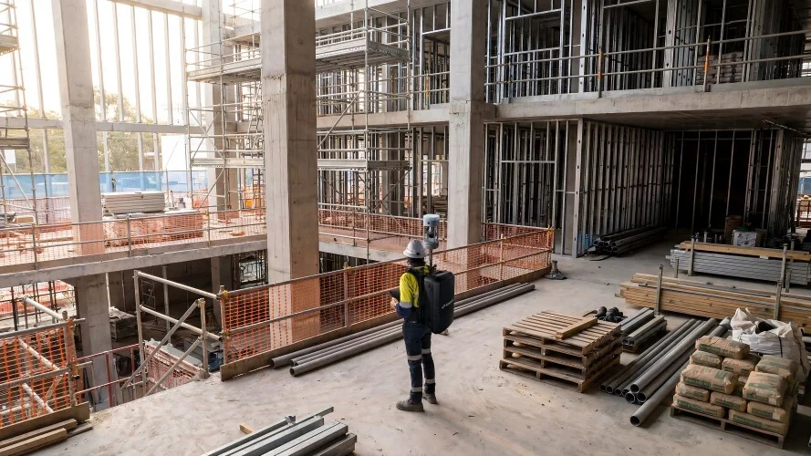
The Emesent GX1 is a ground-based mobile mapping scanner combining RTK SLAM, high-density LiDAR and four 20 MP cameras. It is deployable as a backpack, pole-mount or supported handheld — which means it adapts to different building types and access conditions without requiring separate hardware for different environments.
Emesent states 5–10 mm global accuracy, 5 mm local accuracy and 15 mm RTK/PPK accuracy. For measured building deliverables at LOD 200–350, those figures are appropriate. The SLAM engine tracks position through environmental geometry, which means GX1 continues to operate in basements, plant rooms, service cores and other GPS-denied areas without losing positioning confidence.
Processing runs through Emesent’s Aura software, with E57 outputs that integrate directly with Revit, AutoCAD, Bentley and other BIM and drawing production platforms. Coptrz is a UK partner for Emesent — for more on the full product range, see our Emesent brand page, and for how this fits into the wider survey and construction market, our surveying and construction sector page.
Building a return visit reduction target into your workflow
For survey firms evaluating mobile mapping, the return visit rate is one of the clearest metrics to track before and after adoption. Establish your current return visit rate per project type — how often, on average, does a measured building survey require a second visit? At what cost? Then run a controlled comparison: use GX1 on a project type where return visits are currently a recurring problem, and measure the result.
Even a partial reduction in return visit frequency — one fewer per five projects — has a meaningful impact on margin at scale. For a firm completing twenty measured building surveys per month, eliminating four return visits per month at an average cost of £600 each is a £28,800 annual saving before any throughput uplift is factored in. For more on how to build the full financial case for mobile mapping, see our post on how to build an ROI case for mobile mapping equipment.
Frequently asked questions
The most common causes are missed areas (rooms or sections not captured during the initial visit), registration failures in static scan post-processing, insufficient photographic context for the modelling team, and client-driven scope changes. Mobile mapping directly addresses the first three by providing real-time coverage visibility, eliminating registration, and capturing imagery in the same pass as the LiDAR data.
Not entirely — client scope changes and access issues outside the survey team’s control will always generate some return visits. But the causes that originate in the capture workflow — missed areas, registration failures, insufficient imagery — can be reduced significantly. For many survey firms, a 50–70% reduction in capture-related return visits is achievable with a mobile scanning workflow.
For most measured building deliverables at LOD 200–350, yes. Emesent states GX1 delivers 5–10 mm global accuracy and 5 mm local accuracy. Control points should be established to georeference the dataset and validate accuracy against project requirements. For very high-precision applications — structural monitoring, heritage recording to millimetre tolerances — additional static scanning may be required at specific measurement points.
GX1 produces a georeferenced point cloud in E57 and other standard formats, alongside 360-degree imagery. These are delivered to the modelling team via standard file transfer or Aura Cloud. The modelling team works from the point cloud in Revit, AutoCAD or similar, with the 360-degree imagery available for visual reference throughout the modelling process.
Yes. Coptrz offers practical demonstrations against real building types, workflow advice, training and implementation support for UK GX1 buyers. Contact the team to discuss your workflow and arrange a demo.
Next steps
If return visits are a recurring cost in your measured building survey workflow, the right starting point is to test mobile mapping against a project type where that cost is highest. Bring a building, an access constraint and a current return visit pain, and measure the difference.
View the Emesent GX1 on Coptrz or get in touch to book a demo.
Download Our FREE RPC-L1 Guide
Understand everything you need to know about moving towards commercial drone operations with our RPC-L1 guide.
- Understand what RPC-L1 is and who it is for
- Learn how the CAA transition impacts operators and training routes
- Get a clear breakdown of requirements, costs and next steps


Related Posts
DJI Launches Privacy Mode For Drone Operators
DJI has today launched a new Local Data Mode that stops internet traffic to and from its DJI Pilot app, in order to provide enhanced data privacy assurances for sensitive government and enterprise customers. The release comes after the US Government announced it would consider stopping the use of DJI drones due to data concerns. When […]

LiDAR for Digital Twins: Why Data Capture Quality Matters
Digital twins are only as good as the data they’re built from. That sounds obvious, but it’s a principle that gets overlooked more often than it should. Organisations investing in digital twin development for built assets — infrastructure, buildings, industrial facilities, utilities — frequently focus on the platform, the software and the operational data integration, […]

ELIOS 2 Approved As A Formal Inspection Tool
ELIOS 2 Approved As A Formal Inspection Tool The Elios 2 Drone has been formally approved as an authorised tool for inspection, the first of its kind to be permitted for industry recognised use. In this blog: Elios 2 approved inspection tool by RoNik Inspectioneering and API (American Petroleum Institute) Safer, quicker and less complex […]















