Payloads & Attachments
Find the right payload for your drone mission. Our selection includes a variety of payloads for different applications, ensuring your drone is equipped for any task.
-

AgEagle MicaSense Altum-PT
Price range: £13,544.00 through £16,931.00 Excl. VATMicaSense RedEdge-P incorporates a 12MP high-resolution panchromatic sensor, a new heat sensor with twice the ground resolution of its predecessor Altum, and five separate spectral bands.
This optimized 3-in-1 solution provides high-quality data for advanced remote sensing and agricultural research.
-
AgEagle MicaSense RedEdge-P
Price range: £7,995.00 through £8,471.00 Excl. VATRedEdge-P is a high-resolution multispectral and RGB sensor with five narrow multispectral bands. Its scientific-grade filters make it the perfect camera for calculating multiple vegetation indices and composites.
Featuring a high-resolution panchromatic band, RedEdge-P provides pan-sharpened output resolutions of 2 cm / 0.8 in at 60 m / 200 ft.
-
AgEagle MicaSense RedEdge-P Dual
£13,453.63 Excl. VATExperience enhanced satellite data comparison with the RedEdge-P dual sensor, featuring two cameras and 10 bands.
This high-resolution multispectral and RGB composite drone sensor excels in plant classification, weed identification, environmental research, and water body vegetation analysis. It's a comprehensive dual solution, combining the proven RedEdge-P with the innovative RedEdge-P blue camera.
-
CZI C30N Night Vision Camera
The C30N is an innovative dual-light night vision camera designed for the DJI M300 RTK. It's crafted to support operations in public safety, firefighting, and search and rescue.
-
CZI GL10 Gimbal Searchlight
The GL10 is an innovative gimbal searchlight that boasts cutting-edge AI tracking technology, specifically tailored for the Mavic 3 Enterprise and Mavic 3 Thermal drones.
- Intelligent spotlight featuring AI tracking
- Red and blue flashing lights
-
CZI GL60 Mini Gimbal Searchlight
The CZI GL60 Mini Gimbal Searchlight is tailor-made for the DJI Matrice 30 Series drones, ensuring seamless integration. This advanced lighting tool is perfect for tasks like search and rescue missions and thorough inspections.
- Offers AI-assisted tracking using a 3-Axis Gimbal
- Powerful lighting to a range of 150 meters
-
DJI AL1 Spotlight
£215.00 Excl. VATThe DJI AL1 Spotlight provides powerful illumination for subjects up to 100 metres away, enhancing visibility in low-light conditions. With two modes—Always-On and Strobe—and intelligent gimbal following, it ensures precise, adaptable lighting for a range of aerial applications.
-
DJI AS1 Speaker
£165.00 Excl. VATThe DJI AS1 Speaker offers a broadcast range of up to 300 metres with real-time broadcasting and advanced echo suppression. It supports recorded messages, media imports, and text-to-speech conversion, making it a versatile tool for clear and efficient communication.
-
DJI Neo Two-Way Charging Hub
£25.00 Incl. VATThe DJI Neo Two-Way Charging Hub allows you to quickly and efficiently charge up to three batteries simultaneously. It can also be used as a mobile power source and store batteries for convenient carrying.
Main Features:
- Tri-Charging Capability
- Compact Design
- Fast Charging
- Intelligent Power Management
-

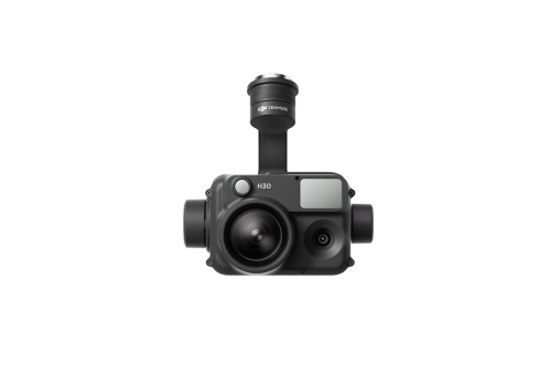
DJI Zenmuse H30
£3,234.00 Excl. VATThe Zenmuse H30 features a wide-angle camera, 400x zoom camera, laser range finder, and NIR night vision auxiliary light.
-
DJI Zenmuse H30T
Price range: £108.30 through £15,790.83 Excl. VATThe Zenmuse H30T features a wide-angle camera, 400x zoom camera, infrared thermal camera, laser range finder, and NIR night vision auxiliary light.
-
DJI Zenmuse L2
The Zenmuse L2 is DJI's latest entry into the LiDAR scanning market, bringing enhanced laser scanning capabilities and increased accuracy.
- Effective Point Rate: 240,000 pts/s
- Smaller laser spots, denser point clouds
- 20MP, 4/3 inch CMOS sensor with mechanical shutter with 0.7s shutter interval
- Detection Range: 450m
- Centre point laser rangefinder
- 5 returns
- Compatible with DJI Matrice 300 & 350 RTK