Conservation Project: Using drones and LIDAR to protect Scottish woodlands
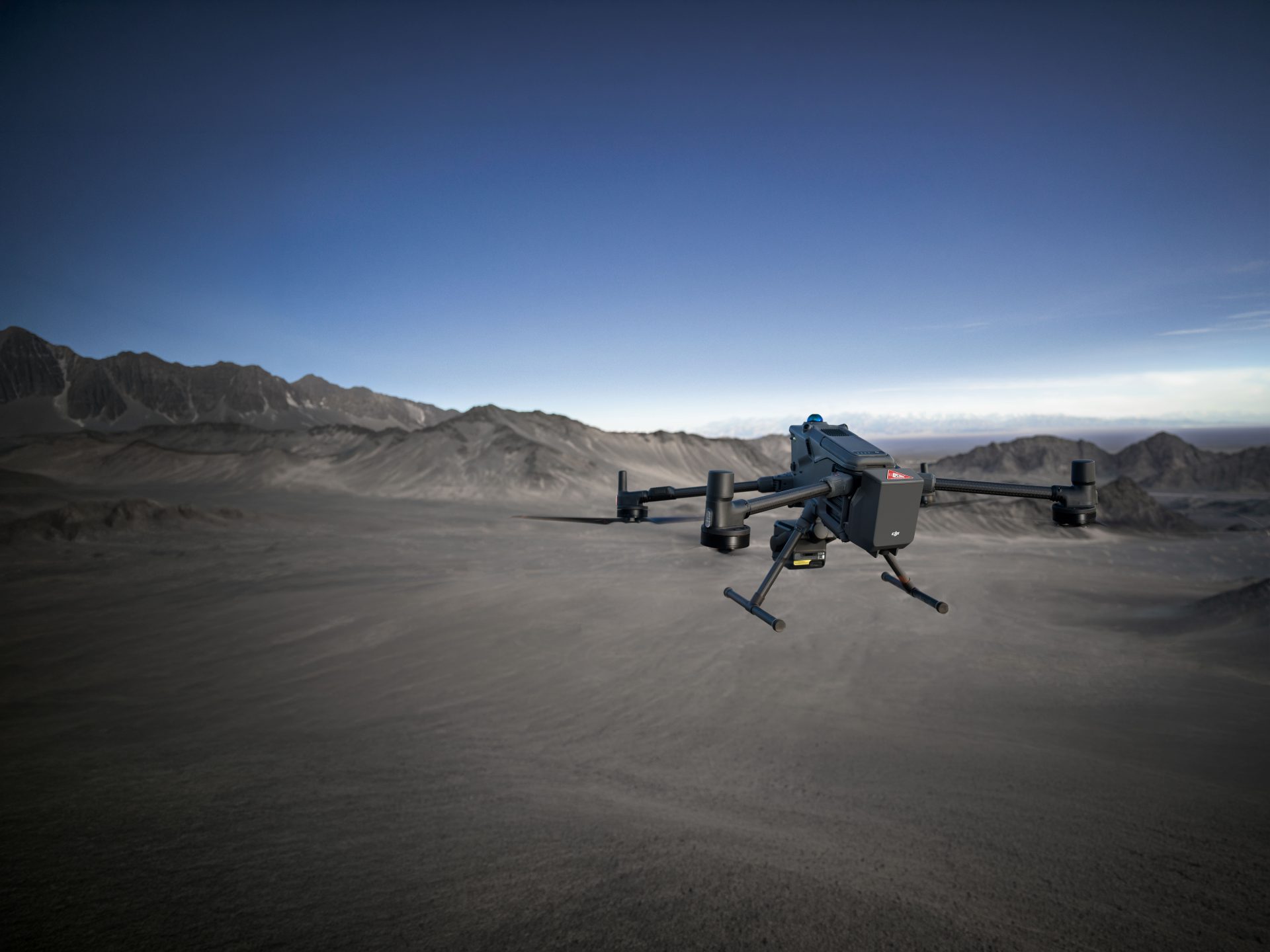
We’re always happy to share stories of the many great things that drones can do, but when one of our own models finds its way into a project that can make a real difference, it makes it feel that much sweeter. In this instance it saw one of our DJI Wind 4 drones transformed with the latest in LIDAR technology to help monitor a variety of environmental factors in forests across the west of Scotland.
The Wind 4 has gone slightly under the radar for a DJI product since its launch in 2017, but it’s a great addition to its Enterprise range and was one of the first to really embrace the customisable approach brought into play with DJI’s own SDK packages – along with its Wind 8 octocopter sibling, offering that extra control and redundancy capacity. Capable of carrying payloads in excess of 10kg the Wind 4 is compatible with most DJI cameras, plus a host of third-party sensors or whatever else you might want to attach to it in order to tailor it to suit your specific needs.
The drone, along with the necessary LIDAR equipment, was originally bought by Maynooth University in County Kildare, Ireland. The university has a service agreement with Dublin-based GeoAerospace, who provide specialised data acquisition and post-processing services for the likes of academia, government agencies and commercial companies, and who operate the drone on the university’s behalf. The LIDAR tech was purchased by Maynooth University under the Science Foundation Ireland Research Infrastructure programme (ref: 16/RI/3705) – but it was over in Scotland that it was really put to good use.
In this case, it was for a company called Ecometrica that wanted to adopt a LIDAR system so that it could see through the tree cover in the dense woodlands in order to map and monitor the terrain and vegetation beneath. By doing so on a regular basis the company can not only track changes to areas – both natural and man-made – but can also control any potential environmental threats, as well as looking for any effects of climate change to the region
Such surveys could have been done with manned aircraft in the past, but using drones significantly reduces the cost, while at the same time increasing efficiency through the gathering of more accurate data in a faster and more flexible manner. To support the project, GeoAerospace designed and built a bespoke airborne pod to enable the Wind 4 to carry a near-full 10kg payload of LIDAR equipment and were also contracted by Ecometrica to operate the system.
What is LIDAR?
LIDAR is the slightly tenuous acronym for ‘light detection and ranging’ (LiDAR, Lidar and lidar are all acceptable uses) – it was original simply a portmanteau of ‘light’ and ‘radar’ but has since been adopted as a variant of radar, or ‘radio detection and ranging’, which isn’t commonly seen as an acronym but let’s not get into that. The obvious difference is that LIDAR uses light courtesy of a pulsing laser, with the time it takes for the laser to bounce back being used to calculate distance. In turn, that makes the likes of 3D mapping that much easier.
The tech dates back to the 1960s and has since been used in a variety of aerial, as well as ground-based and mobile applications. Courtesy of a laser altimeter it was used by the crew of Apollo 15 to map a section of the moon’s surface in 1971 and, for better or for worse, it’s also the technology used in police speed guns. As with a range of multispectral cameras, such as the Parrot Sequoia and MicaSense RedEdge (both of which are compatible with the DJI Wind 4), LIDAR can be used across a wide spectrum of sources – such as ultraviolet and near-infrared light.
One key advantage of LIDAR over more traditional cameras is that it can ‘see’ through some layers that the visual eye can’t, such as clouds, surface water or – as it very pertinent in this case study – tree cover. So, for the likes of Ecometrica, which is operating in largely evergreen forestry, so even waiting until autumn to get a clearer view of the land isn’t an option, this enables it to get a line of sight through the treeline and down onto the ground below.
Going Green
Ecometrica’s work is being done in partnership with Scotland’s Forest Commission, Scottish Orienteering, the Woodland Trust and Edinburgh University – and with each looking to make use of different data from the same surveys for various conservation projects, it really does highlight the flexibility of the system. For example, one branch might be looking to map the terrain, so the capacity to pick out rivers, pathways, rock formations and the like with centimetre accuracy and transform that data into 3D maps to compare and contrast against with future surveys is key.
Another partner is looking at the threat posed by rhododendron bushes running wild in the region. Though beautiful to look at, these bushes are a hive for a fungal disease that harms the surrounding trees, while its leaf litter is also toxic to some indigenous flora. With many LIDAR systems you can adapt them (either manually or through machine learning) to recognise and differentiate between certain types of soil or vegetation – so in this instance they can tailor the camera to highlight and track the spread of these rhododendron bushes and then send in the relevant teams to stem the growth or eliminate the threat.
On top of these examples, the team can also monitor the likes of soil erosion, the changing face of deforestation in the area, evaluate the spread of forest fires or look for signs of drought, as well as tracking the inevitable effects of human interaction in the region. And it needn’t stop in Scotland, with Ecometrica using its ongoing work as a testbed for the UK Space Agency-funded Forests 2020 project which is looking to monitor similar threats in tropical forests. There are also plans to take the system out to west Africa to track issues such as illegal logging, charcoal burning and the effects of felling trees to make space for lucrative cocoa plants.

The Drone Zone
As mentioned, such surveys have previously been done with manned aircraft, while super large-scale scans can even be done courtesy of the International Space Station’s GEDI system. Not only is using a drone a much simpler and cheaper alternative to hiring a helicopter – with even the largest of commercial UAVs also much less intrusive to the local wildlife – the pay-offs with using a drone also comes down to the quality of the data you can collect.
In simple terms this could be seen as high and low altitude surveying. As you might expect, being higher means you can see more and therefore take in a much larger area in a shorter time. However, the closer you can get to your subject then the more you can see of it, so where precision is key then being able to bring a drone down as close as possible can be hugely beneficial. Even where LIDAR can help you peer through a treeline, having the capacity to swoop down below it if needed – something a helicopter certainly couldn’t – can make a big difference.
With the rise of automation and GPS technology in UAVs, it’s also much easier to be able to set flight plans and waypoints, so that you can easily repeat the exact same route – with or without a pilot taking hands-on control. Subsequently you can get centimetre-accurate comparisons from survey to survey, making it even easier to spot even subtle changes. So, for the likes of Ecometrica it can highlight any specific area (water sources, tree foliage, that pesky rhododendron and so on) and track its development from one flight to the next with just a few clicks of a button.
“As we gradually transition into regulated Beyond Visual Line of Sight (BVLOS) operations we are at a point where it is now faster, more cost effective and ultimately safer to collect data at scale using drones.” Fearghus Foyle, GeoAerospace
The Bigger Picture
As well as proving a crucial tool in conservation projects such as this, there are many other areas where LIDAR-equipped drones can do great things. Agriculture is perhaps the most obvious crossover with the work being done here, with the capacity to track crop yields and water levels in order to analyse where best to seed and fertilise, or where you might need either extra drainage or to get the sprinklers out in order to maximise output
Archaeologists and heritage agencies have also been making good use of the technology, as LIDAR can be used to glimpse a little beneath the surface and see the otherwise hidden imprints that reveal where old buildings or large gardens once stood. The likes of biologists and geologists can also use the technology to track changes in the topography of any given region, be it a river, glaciers, cliff erosion or those Scottish forests.
Similarly LIDAR technology is also being embraced by emergency responders, where the likes of landslides, earthquakes and avalanches lead to a drastic change in the landscape. But with a LIDAR-equipped drone you can a quick overview of any situation and possibly get a crucial view at what lies beneath the surface devastation. As with most sensor technology it’s not a big leap to transform the data into user-friendly images, with Digital Elevation Models and Digital Surface Models (or DEMs and DSMs as you’ll more likely see them named) a great way to see your results on display in a relatively short period of time.
So while it’s great to see the brilliant work that Ecometrica and GeoAerospace are doing in Scotland (and Ireland!) with one of our Wind 4 drones, there’s a wealth of other active use cases for LIDAR technology already in place. And with the adaptability and customisation available with these systems, there’s every chance you could follow suit and create the perfect set-up for your professional needs – and maybe even find an entirely new way to help survey and ultimately protect the planet. Either way, to all involved, keep up the great work – and do let us know if we can help you find the perfect aerial solution to take things to the next level!
“When BVLOS drone operations are combined with compact, lightweight, high-performance LIDAR systems, it is now possible to cover up to 1000 hectares per hour capturing precise survey grade data.” Fearghus Foyle, GeoAerospace

Download Our FREE RPC-L1 Guide
Understand everything you need to know about moving towards commercial drone operations with our RPC-L1 guide.
- Understand what RPC-L1 is and who it is for
- Learn how the CAA transition impacts operators and training routes
- Get a clear breakdown of requirements, costs and next steps


Related Posts

Coptrz Commercial Drone Exhibition 2022: Line-up Announced
Welcome to Coptrz Commercial Drone Exhibition 2022. We have been working tirelessly over the last few months to bring you an event that showcases the UK’s most comprehensive range of industry-leading drone technology. Here’s what we have in store for you with only one week to go! Coptrz Commercial Drone Exhibition will bring together industry-leading […]
Drones at sea: how to detect & defeat threats
When you think of superyachts, long days gently navigating the seas and enjoying incredible luxury on board might spring to mind. But while superyachts can represent the perfect aquatic getaway, they are subject to an increasing number of safety and privacy concerns. Some of these are centred around drones. They have spiked in recreational and […]
Why Choosing a DJI Authorised Repair Centre in the UK Matters
In the UK drone market, support providers commonly position around three themes because these are what customers actually worry about: technical competence, turnaround speed and confidence that the aircraft will come back in a flight-ready condition. Competitors emphasise DJI-trained technicians, multi-point testing, warranty-backed work, genuine parts access, and fast or express repair routes because buyers […]