Drones are a big part of the construction industry’s digital transition, which is happening right now. According to Research and Markets, the global construction drone market is projected to grow to £9.99 billion by 2029, achieving a compound annual growth rate (CAGR) of 14.1%. This strong growth highlights how drones are steadily becoming essential tools rather than optional add-ons for modern construction workflows. The expansion is being driven by several key factors such as the adoption of 5G technology, which enables faster data transmission and real-time collaboration, the rise of Drone-as-a-Service (DaaS) business models that make high-end equipment accessible without heavy investment and the development of smart cities, where connected infrastructure relies heavily on precise aerial data.
At the same time, emerging trends are changing how drones are integrated into construction projects. These include the rise of hybrid drone solutions that combine the endurance of fixed-wing drones with the agility of multi-rotor designs that can cover expansive areas simultaneously. The growing preference for subscription-based models also reflects how companies are prioritizing flexibility and scalability. Artificial Intelligence (AI)-driven analytics help drones to process data faster, detect structural anomalies, and support predictive maintenance. To learn more about the use case, challenges and recent developments in the construction industry check out our previous blog here.
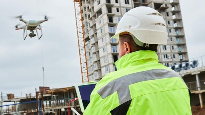
Drones in Construction Drones can capture high-resolution imagery and sensor data, producing detailed 3D models, orthomosaic maps, and visual reports that support every stage of a project. For example, surveying drones equipped with high-resolution cameras or Light Detection and Ranging (LiDAR) sensors can map vast construction sites in a fraction of the time required by traditional surveying teams. This technology not only accelerates site preparation but drones can now provide as precise data as traditional methods.
In earthwork and volume measurement, drones help calculate cut and fill volumes with exceptional accuracy, reducing material waste and rework. Progress monitoring is another major use case, where regular drone flights document site developments, allowing teams to compare actual progress against Building Information Modeling (BIM) plans and project schedules. For infrastructure inspection, drones equipped with thermal or zoom cameras are used to examine bridges, roads, and pipelines for cracks, corrosion, or leaks, tasks that would otherwise place workers in risky conditions.
Beyond efficiency and safety, drones are valuable for environmental and site assessments, particularly in rugged or remote locations that are difficult to access. They gather critical data on erosion, vegetation, and hydrology to inform sustainable planning. However, challenges such as regulatory restrictions, battery limitations, and data privacy remain.
Why Should You Have a Drone Strategy?
For construction CEOs, drones are a leadership decision that determines how efficiently, safely, and competitively a company will operate in the next five years. Across every project phase, from pre-construction surveying to post-completion maintenance, drones provide the kind of visibility that traditional methods can’t match. But without a defined strategy, even the most advanced UAV fleet risks becoming underused or fragmented. A drone strategy ensures alignment between corporate goals, operational workflows, and the data intelligence drones deliver. The conversation around drones is no longer about whether to adopt them, but how to do so strategically.
One of the biggest shifts we’re seeing is that drones have become central to data-led decision-making. Every flight generates thousands of data points such as orthomosaic maps, point clouds, volumetric calculations, and progress imagery that, when managed properly, can reduce project uncertainty and improve financial forecasting. CEOs who recognise this are treating drone data as a strategic asset, integrating it with their BIM and digital twin workflows to create real-time project intelligence. This builds a foundation for predictive planning and proactive maintenance that are key drivers of long-term profitability.
Another strategic consideration is scalability. Whether through in-house teams or DaaS providers, leaders are rethinking how drone operations fit into broader digital transformation. The most forward-thinking companies are building internal competencies, training General Visual Line of Sight Certificate (GVC)-certified pilots, developing data governance policies, and investing in AI-driven analytics to make drone insights repeatable across multiple projects. In parallel, partnerships with technology providers and RAE’s like COPTRZ, ensure compliance, safety, and continuous upskilling.
Ultimately, a well-defined drone strategy gives you readiness for regulation, automation, and the competitive nature of 2025 and beyond.
Here are three essentials every construction CEO should prioritise:
- Integrate drone data into core decision-making: Use UAV insights alongside traditional methods for real-time, data-backed project control.
- Invest in people and partnerships: Collaborate with expert providers to ensure safe, compliant, and scalable drone use.
- Align drones with business outcomes: Treat drones as strategic enablers of safety, sustainability, and operational excellence.
Success Stories in the Industry & Partnerships
A successful programme embeds drones into workflows, vendor arrangements, data pipelines, and governance.
Here are five major trends that define what a forward-looking strategy must cover:
- Hybrid drone solutions that combine endurance and manoeuvrability
- Subscription or other recurring commercial models that enable predictable cost structures
- Specialised drones for task-specific payloads and sensing
- AI-driven analytics that turn imagery and sensor captures into actionable insights.
Castle Keep Surveys
Castle Keep Surveys, led by founder Mick Dixon, is a great example of how a clear drone strategy can completely change a traditional business. With more than 30 years in surveying, Mick had seen every tool in the trade from GPS units to scaffolding but nothing compared to the step change brought by drones. The company bought its first DJI Phantom 4 in 2019, mainly to film sites for clients. It didn’t take long for the team to see the real value of drones in mapping and data capture.
By using drones to collect accurate aerial data, Castle Keep Surveys started producing faster, more reliable results. The move to advanced drones like the DJI Matrice 300 RTK and Zenmuse P1 opened the door to 3D imaging and LiDAR scanning, giving clients incredibly detailed maps and models. To keep pace with this new technology, the company also invested in its people. And provided them with professional drone training certifications in partnership with COPTRZ. Today, Castle Keep Surveys operates with ten trained pilots and a fleet of drones.
Innovair: Smarter Construction Monitoring at Inch Cape Wind Farm
Innovair is another example of how drones can make complex construction projects simpler, faster, and safer. The company supports the Inch Cape Offshore Wind Farm, a huge development 15 kilometres off the Angus coast with 72 new turbines. To keep construction of its substation on track, Innovair needed clear, accurate data to share between contractors, engineers, and stakeholders. Their answer was the DJI Matrice 300 Real-time kinematic positioning (RTK) drone, fitted with the Zenmuse P1 45MP full-frame camera.
With a flight time of up to 55 minutes and advanced AI capabilities, the M300 collected detailed, geotagged images and HD video flyovers. These regular drone missions captured progress along the same flight paths each week, giving project teams a consistent and comparable view of every stage. The high-quality imagery made it easier to spot issues early, make quicker decisions, and avoid costly delays.
Working with COPTRZ, Innovair also gained access to professional training, repair services, and technical support. This helped them run efficient, compliant operations and make the most of their drone data. Innovair’s experience highlights a key lesson for construction CEOs that investing in drones creates a reliable system for decision-making that keeps major projects running on time and within budget.
COPTRZ has helped over a thousand companies to bring drone technology into their daily operations. Their 360° approach covers everything a business needs, including training, hardware, software, licensing, and expert consultancy. This allows teams to work faster, safer, and more efficiently. Many clients have reduced time on site by up to 80% while cutting costs and improving accuracy.
COPTRZ partners with Premium Positioning to integrate a European RTK Correction Network into their drone packages. This means customers can now get centimetre-level accuracy without needing a separate licence or provider. With over 2,000 base stations across 25 countries, 99.98% uptime, and full Global Navigation Satellite System (GNSS) compatibility, the RTK Premium Network ensures every flight delivers reliable, high-precision data.
Conclusion
To stay ahead in 2025, construction leaders need a clear drone strategy. Courses like Level 4 Complete Knowledge of UAV Surveying help you become proficient in applying this technology, positioning you as an expert. You’ll gain the skills to operate drones safely, interpret aerial data confidently, and improve project outcomes. For construction CEOs, this approach offers a clear model for 2025: combine technology, training, and connectivity in one place, and you’ll have safer, faster, and more profitable operations.
Download our FREE GVC Training Guide
Learn everything you need to know about becoming a drone pilot with our GVC training guide.
- Get a full course roadmap to understand every step of the journey
- Contains clear answers to all of the frequently asked questions
- Get a transparent and comprehensive breakdown of course costs

Related Posts

How High Can A Drone Fly? Maximum Heights & Limits Uncovered
As drone users, we often wonder how we can get the most out of our purchase. Drones come in all shapes and sizes, with each drone being unique. That is why working out how high a drone can fly can be tough work. The answer to this question is variable, depending on the drone’s capabilities. […]

Ready for Business: How the Mavic 2 Enterprise expands upon the original Mavic 2 Series
DJI has certainly been busy of late, with the long-anticipated announcement of the Mavic 2 pairing followed recently by the Phantom 4 RTK and now the Mavic 2 Enterprise. The latter two are interesting because they mark a clear shift by DJI towards creating more specific solutions for the professional market. Sure, the company has […]

Cadastral digitisation made easy with PIX4Dmatic
Digitising cadastral surveys is pivotal for modernising land management and urban planning. Traditional methods often involve extensive fieldwork, which can be time-consuming, costly, and challenging, especially in areas with complex terrains or limited accessibility. However, advancements in drone technology and photogrammetry software have revolutionized this process, enabling efficient and precise data collection. A compelling example […]


