Drones (unmanned aerial vehicles, UAVs) have become indispensable tools in civil engineering, offering aerial access and data collection for many tasks. They are widely used to capture high-resolution imagery and sensor data, enabling precise 3D models, orthomosaic maps, and inspections that inform design, construction, and maintenance. For example, surveying drones equipped with high-res cameras and LiDAR can map terrain and sites for planning, while inspection drones (often with thermal or zoom cameras) safely examine structures like bridges or dams without sending people into hazardous environments. Overall, UAVs improve efficiency, accuracy, and safety across the construction.
Use Cases
Civil engineers use drones for a variety of applications across project phases:
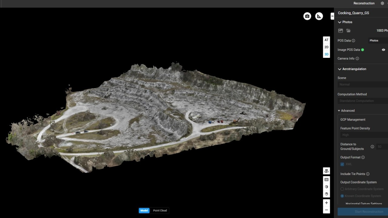
- Surveying and Mapping: Drones rapidly capture aerial images of sites. Photogrammetry software stitches these images into detailed 2D orthomosaics and 3D terrain models. These maps show elevations, contours, and features, aiding site planning and design. For large projects, fixed-wing UAVs can cover many acres per flight, greatly accelerating surveys compared to ground crew.
- Earthwork and Volume Measurement: By repeating flights over time, drones enable earthwork monitoring. High-resolution aerial data allow precise cut/fill volume calculations and slope analysis. For instance, a study of an apartment project in Seoul used UAV-based mapping to compute cut-and-fill volumes and monitor terrain changes over time. This level of accuracy minimises rework and optimises resource use on site.
- Construction Progress Monitoring: Regular drone flights provide visual updates of construction progress. Aerial photogrammetry or video can be overlaid on design plans or BIM models to verify that work is on schedule and built to specification. For example, during the building of Allianz Field stadium (USA), drones were flown periodically to capture site images. The data were processed in the cloud (via software like Pix4D) to track earthwork volumes, compare against design plans, and update stakeholders.
- Infrastructure Inspection: Drones inspect hard-to-reach civil infrastructure such as bridges, roads, towers, pipelines, and utilities. High-resolution and thermal cameras on multi-rotor UAVs can scan structural elements (even underneath bridges) for cracks, corrosion, or leaks. The aerial perspective and zoom allow engineers to spot defects invisible from the ground. For example, US and state departments of transportation now use drones for bridge inspection; autonomous flights can capture sub-millimetre imagery under decks, enabling consistent ratings and early fault detection while keeping crews on the ground.
- Safety and Security Monitoring: On construction sites, drones survey areas for safety compliance and hazards. They can monitor worker practices, verify that safety zones are clear, and even assist in emergency response by locating people or hotspots (using thermal sensors). Drones are also used for post-disaster assessments: e.g. after floods or earthquakes, UAVs rapidly map damage to roads, bridges, and buildings from the air, helping prioritise repairs.
- Environmental and Site Assessment: Drones can survey rugged or remote terrain (steep slopes, floodplains, forested areas) that are difficult for crews to access. They can gather data on erosion, vegetation, and hydrology to inform site selection and risk mitigation. This access makes it safer and easier to evaluate challenging environments, from mountain roads to beaches and cliff faces.
Technologies Used
Sensors and Payloads: Drones carry various instruments for data collection:
- Photogrammetric Cameras: High-resolution RGB cameras capture overlapping aerial photos. These images are processed (using structure-from-motion algorithms) into 2D orthomosaic maps and 3D point clouds/ meshes. Photogrammetry is widely used for mapping terrain, volumes, and site progress, since it is relatively low-cost and can use consumer-grade cameras.
- LiDAR (Light Detection and Ranging): Airborne LiDAR uses laser pulses to measure distance, producing very dense and accurate 3D point clouds of terrain and strictures. It excels in penetrating vegetation and capturing precise elevations. LiDAR-equipped drones can model bridges, buildings, and terrain with centimetre-level accuracy. The downside is higher data complexity and cost.
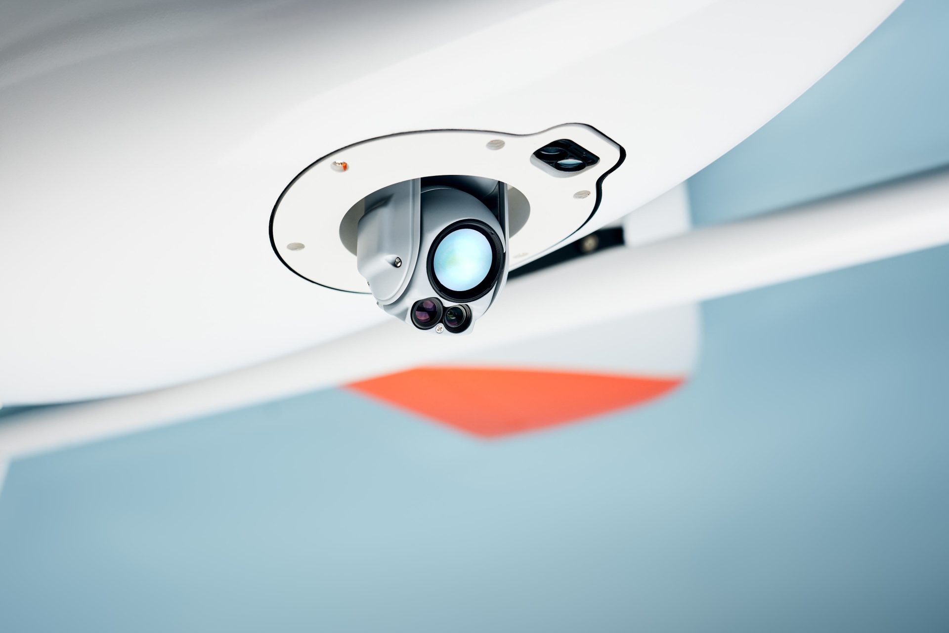
- Thermal/Infrared Cameras: Thermal sensors detect heat radiation and create thermal images. Drones with thermal cameras identify issues like insulation defects, moisture intrusion, electrical faults, or heat losses in infrastructure. For example, a thermal scan can reveal “cold spots” in a roof or overheated equipment, enabling proactive fixes.
- Other Sensors: Some drones carry multispectral or hyperspectral cameras for vegetation and environmental monitoring (useful in erosion or watershed projects), or specialised sensors like gas detectors for pipelines. Radio-frequency (RFID) readers have even been tested on drones for asset inventories.
Data Processing and Software: After a UAV flight, specialised software analyses the data:
- Photogrammetry Software: Tools like Pix4Dmatic and DJI Terra process aerial images into georeferenced maps and 3D models. These platforms can calculate volumes (stockpiles, cut/fill), measure distances, and overlay the imagery on CAD/BIM plans.
- LiDAR Processing: Software such as Aura, DJI Terra and Inspector handle LiDAR point clouds for terrain modelling and feature extraction.
- Inspection and Visualization Tools: Other applications (e.g. Propeller, Pix4Dcloud) generate orthomosaics and allow site comparisons over time. Many firms integrate UAV data into BIM or GIS platforms for visualization and as-built verification.
Benefits
Using drones in civil engineering offers several key advantages:
- Time Savings: UAVs can survey sites and collect data far faster than traditional methods. For example, a drone can capture imagery over an entire site in minutes or hours that would take surveyors days to cover on foot. Our analysis found that drone surveys can be over 70× more efficient than manual surveys, drastically reducing labour hours.
- Improved Accuracy: Aerial mapping provides high-resolution, georeferenced data. Drones enable precise 3D models and measurements (to centimetre accuracy), minimising human error. In earthwork projects, this means highly accurate volume calculations and cut/fill analysis. In inspections, drones reveal small defects (hairline cracks, corrosion spots) that might be missed from the ground. Overall, this accuracy helps avoid costly rework and keeps projects closer to design intent.
- Enhanced Safety: UAVs reduce risk to personnel. Dangerous tasks (like inspecting tall structures, live highways, or deep excavations) can be done remotely by drones. For instance, bridge inspectors can fly a drone under and around a span instead of using scaffolding or climbing, avoiding falls or crashes. Drones can also be deployed in hazardous environments (collapsed buildings, fire zones) for search-and-rescue or assessment, keeping people out of harm’s way.
- Cost Efficiency: By speeding up surveys and cutting labour, drones often lower project costs. Fewer field hours mean lower manpower expenses, and early detection of issues avoids expensive delays. A construction project that scans progress with drones can reduce downtime and rework, improving overall productivity. In one case, replacing periodic manual surveys with UAV mapping saved an engineering team substantial time and money on a large site.
- Access to Difficult Terrain: Drones can reach sites or structures that are inaccessible or dangerous for humans. Steep slopes, remote wilderness areas, deep water bodies, or confined indoor spaces (like tunnel shafts) can be surveyed by UAVs. This capability is invaluable for projects in challenging topography, where traditional surveying would be impractical.
Challenges and Limitations
Despite the benefits, several issues limit drone use in civil engineering:
- Regulatory Hurdles: Civil UAV operations must comply with aviation rules. Operators often need licenses, permits, and flight approvals. Drones cannot fly unrestricted – restrictions apply near airports, urban areas, and sensitive sites. Navigating these regulations (which vary by country) can be complex and time. For example, European drone flights must also address privacy (GDPR) when capturing site images.
- Weather and Environment: Adverse conditions significantly impact UAV operations. Strong winds, rain, fog, or extreme heat can ground drones or degrade data quality. Wind can destabilize multi-rotors, rain may damage electronics, and cold can shorten battery life. As a result, surveys may be delayed by weather, affecting project schedules.
- Limited Battery Life: Most commercial drones have flight times on the order of 20–30 minutes per battery. This limits the area covered per flight and requires frequent landing for battery swaps. Larger projects may need multiple batteries or drones to maintain coverage, complicating logistics. Battery constraints are an active research area, with efforts toward longer-lasting or alternative power (e.g. hydrogen fuel cells).
- Data Privacy and Security: UAVs capture detailed imagery of sites, people, and surroundings, raising privacy and confidentiality concerns. Unauthorized or inadvertent capture of sensitive information (e.g. neighbouring private property, workers) can violate laws or corporate policies. Companies must implement data security measures (encryption, controlled access) and comply with privacy regulations when storing and using drone data.
- Need for Skilled Operators: Effective drone use requires trained pilots and analysts. Flying complex UAVs safely (especially fixed-wing or BVLOS) takes practice, and post-processing large datasets demands technical expertise. For instance, bridge inspections need operators who can navigate tricky wind and extract useful measurements from images. A shortage of experienced drone professionals can be a bottleneck.
Recent Developments
Drone technology continues to evolve, enhancing civil engineering applications:
- AI and Autonomy: New drones incorporate artificial intelligence for semi-autonomous or autonomous flights. AI systems can plan flight paths, detect obstacles in real time, and even recognize structural defects in live video. Research predicts more autonomous missions (beyond visual line of sight) in the near future. For example, machine learning algorithms are being used to automatically detect cracks or damage from drone imagery.
- Digital Twins and BIM Integration: Drones are increasingly used to create or update digital twins of infrastructure. High-precision drone data speeds the generation of virtual 3D replicas for planning and maintenance. Real-time UAV surveys can be fed into BIM systems so that physical changes are immediately reflected digitally.
- Advanced Sensors and Connectivity: Lighter and cheaper LiDAR sensors have made UAV mapping more accessible. Drones now often carry multiple payloads (e.g. LiDAR + RGB + thermal) on a single flight. Meanwhile, improvements in 5G and edge computing allow near real-time streaming of UAV data to analysis centres. This enables live monitoring of sites (e.g. remote safety supervision) and immediate decision-making.
- Multi-Drone Systems: Emerging research (mostly military-inspired) is looking at coordinating multiple drones (swarms) for large-area survey or emergency response. While not yet common in civil projects, advances in swarm control could one day let fleets of UAVs cover highways, pipelines, or disaster zones in parallel.
Conclusion
Drones have rapidly transformed civil engineering by enabling faster, safer, and more accurate data collection across all phases of infrastructure development. From initial site surveys to ongoing inspections and construction monitoring, UAVs offer unmatched aerial access and real-time insights that enhance decision-making, reduce costs, and improve worker safety. With the integration of advanced sensors like LiDAR and thermal imaging, and the rise of AI-driven data analysis and digital twins, drones are not just tools but integral components of modern engineering workflows. Despite challenges such as regulatory constraints, weather sensitivity, and limited battery life, ongoing technological advancements continue to expand their capabilities. As adoption grows and drone platforms become more autonomous, connected, and cost-effective, their role in civil engineering will only become more central, redefining how infrastructure is planned, built, and maintained.
Download our FREE GVC Training Guide
Learn everything you need to know about becoming a drone pilot with our GVC training guide.
- Get a full course roadmap to understand every step of the journey
- Contains clear answers to all of the frequently asked questions
- Get a transparent and comprehensive breakdown of course costs

Related Posts

The Rise Of The Delivery Drone
When will commercial drones be used for deliveries in the UK? Commercial drones are well established in a variety of industries, such as agriculture, emergency services, and construction. In these industries, drones have revolutionised ways of working – they have allowed for inspection, surveying, search, and mapping much faster than could be done previously. They […]
COPTRZ DRONE-FLX Leasing Solution Now Available
COPTRZ has today announced the release of DRONE-FLX, an industry-first leasing solution that provides a cost-effective way for businesses and public bodies to enjoy the benefits of the latest drone technology. With costs spread over a three-year period, the latest drone hardware can be bundled with training and software to enable an effective drone strategy […]

How can local councils use drone technology?
Local councils are responsible for delivering over 800 services, with duties ranging from waste management to social care. In fact, councils have a statutory liability to meet the needs and demands of individuals or communities. Under these responsibilities, council staff are required to not only deliver on their demands, but to also do so in […]