Emesent GX1 RTK SLAM Scanner
The World’s Most Accurate RTK SLAM Scanner.
Download the GX1 Product Brochure Now
Get the full breakdown of the world’s most accurate RTK SLAM scanner, including features, workflow and specifications, in this free GX1 guide
Beyond the Limitations of Traditional Mapping
The Emesent GX1 RTK SLAM scanner solves the core industry conflict: the choice between rapid data acquisition and survey-grade georeferencing.
01
Accuracy Without the Drift
- The Challenge: In large-scale or featureless environments, standard SLAM is prone to accuracy degradation and warping, requiring extensive manual correction.
- The Outcome: Survey-Grade Integrity. By fusing pioneering SLAM with an integrated RTK/PPK receiver, the GX1 ensures sub-centimeter repeatability and 5-10mm global accuracy from the start.
02
Productivity Without the Downtime
- The Challenge: Tripod-based scanning or multi-sensor setups require significant site time, increasing labor costs and personnel exposure in hazardous zones.
- The Outcome: Rapid Site Digitalization. Capture survey-grade data at walking speed. The handheld, all-in-one architecture streamlines field operations, reducing time-on-site by up to 80%.
03
Clarity Without the Gaps
- The Challenge: Raw point clouds without high-resolution imagery lack the visual detail necessary for comprehensive AEC inspection and stakeholder review.
- The Outcome: Comprehensive Site Context. Integrated quad-cameras provide 4x20MP of visual data. Automatically colorize point clouds and generate 360° panoramas for complete project transparency.
04
Versatility Without the Complexity
- The Challenge: Relying on external GNSS, separate cameras, and cables creates logistical complexity and increases the potential for equipment failure in the field.
- The Outcome: Unified Hardware Ecosystem. A singular, IP65-rated solution designed for versatility. Deploy via handheld, backpack, or vehicle mount with zero external dependencies or cabling.
Accuracy you can trust.
The Emesent GX1 RTK SLAM scanner is the world’s most accurate terrestrial mapping solution, combining pioneering SLAM algorithms with integrated georeferencing.
Global Accuracy
5-10mm via GCP or 15mm via RTK/PPK
Local Accuracy
5mm
Precision
Up to 2mm
Visual Resolution
4 x 20MP high-resolution cameras
Internal Storage
2TB SSD (approx. 40 hours of data)
Ruggedized Rating
Designed to IP65 standards
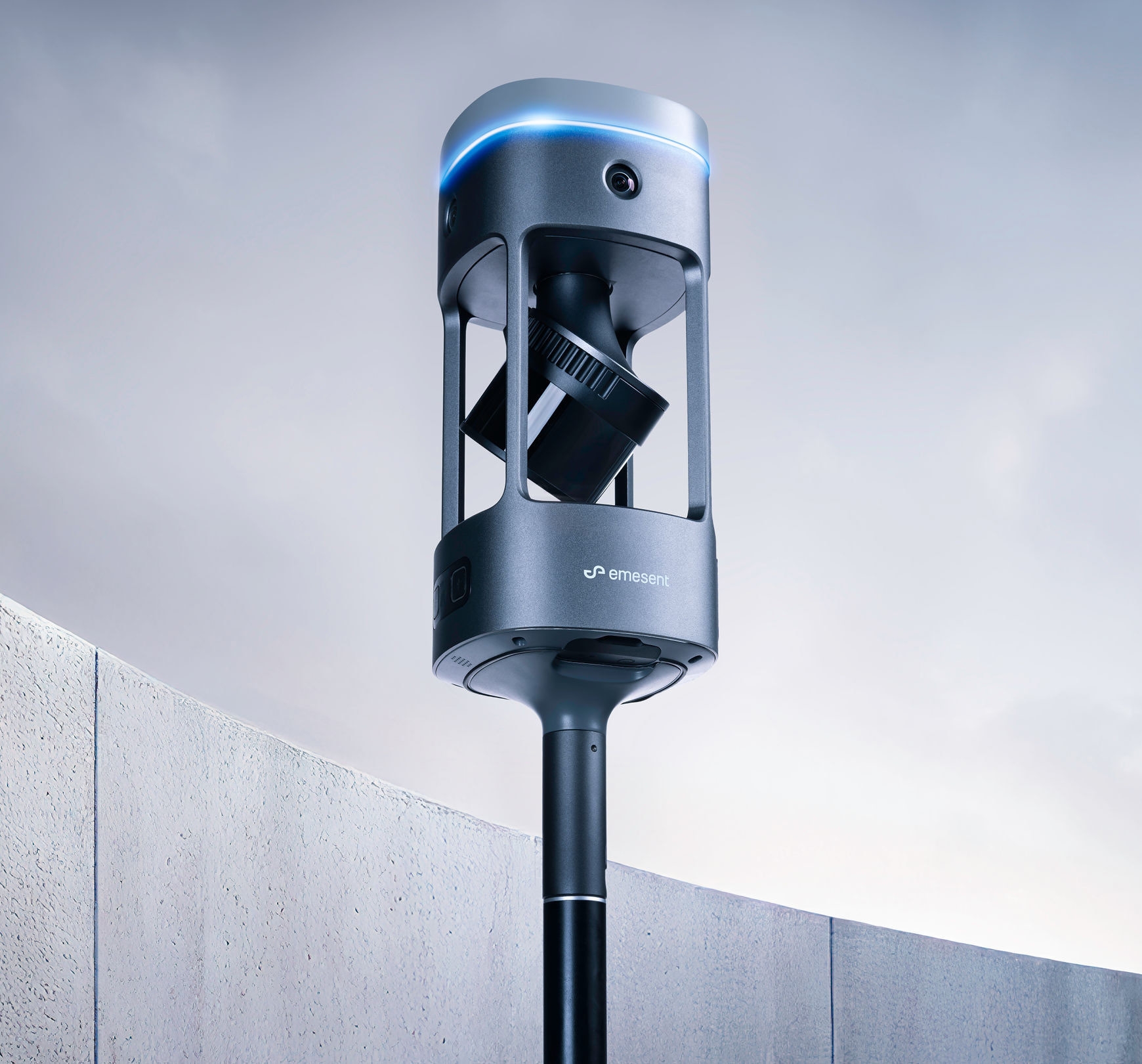
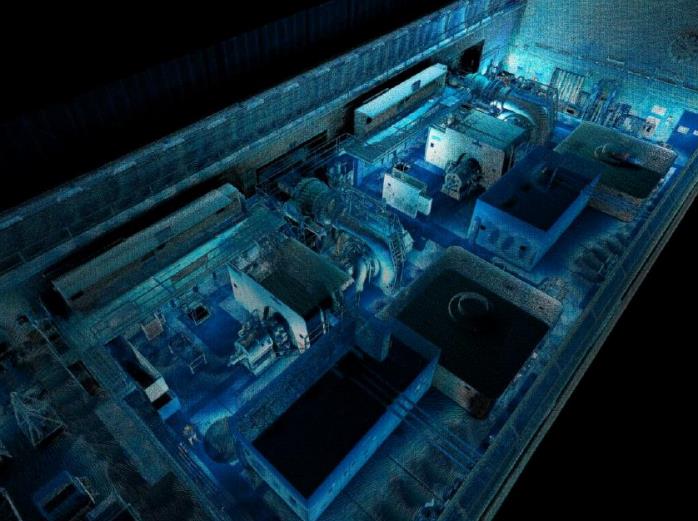
Quad-Camera Integrated Vision
The Emesent GX1 features a sophisticated quad-camera array, integrating 4 x 20MP sensors directly into the scanner body. Capturing high-frequency 10 FPS video with a near-spherical field of view (360° Horizontal x 284° Vertical), this system provides total site coverage. By removing the need for external camera kits or complex wiring, the GX1 remains perfectly balanced and streamlined for high-speed data acquisition in any AEC environment.
GX1 Features
Emesent SLAM
Proven in some of the world’s most extreme environments via autonomous drone mapping, Emesent SLAM is the powerful technology that drives GX1’s impressive accuracy results.
Integrated RTK
GX1’s premium 448-channel RTK receiver delivers 0.6cm + 0.5ppm horizontal and 1cm + 0.5ppm vertical accuracy – supporting real-time monitoring.
Superb 360° imagery
360° horizontal and 284° vertical coverage, GX1 captures every detail in a single pass, reducing mission times and saving on return visits.
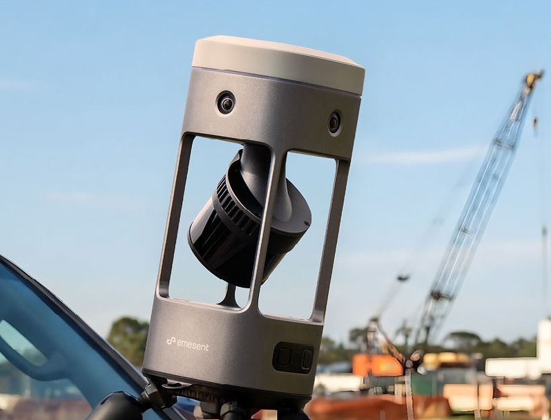
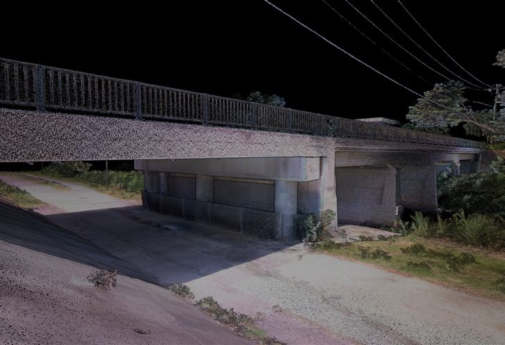
Best-in-class LiDAR
1.92 million points per second, a 300m range for high-precision and 360° scanning for capturing accurate data quickly and reliably.
Unlimited Processing, No Usage Fees
Process unlimited datasets on-premise with no per-scan charges or cloud processing costs that eat into your project margins.

Enhanced End-to-End Workflow
A complete survey system from in-field monitoring and capture to point cloud processing – and integrations with industry platforms like Revit.
The most accurate RTK SLAM scanner in the world.
| Global GCP accuracy | 5-10mm |
| Global RTK/PPK accuracy | 15mm |
| Local accuracy | 5mm |
| Precision | Up to 2mm |
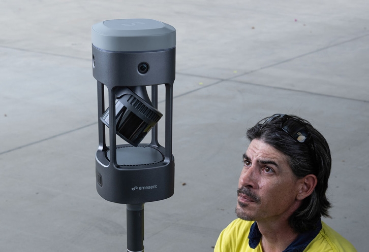
One Device, Any Project
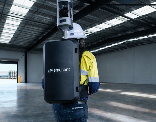
Backpack Mode
Features an adjustable center of gravity and variable scanner height for ergonomic, long-duration walking scans.
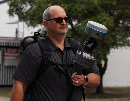
Handheld Harness
Maximum support for complex, indoor environments where maneuverability is key.
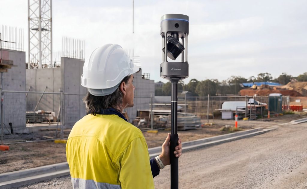
Survey Pole
A familiar 5/8" thread compatibility for surveying cramped spaces, ensuring maximum ceiling and ground coverage.
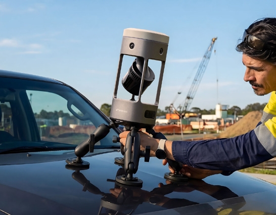
Vehicle Mount
Optimized for rapid, secure large-area scanning without the need for additional electronics in the mount.
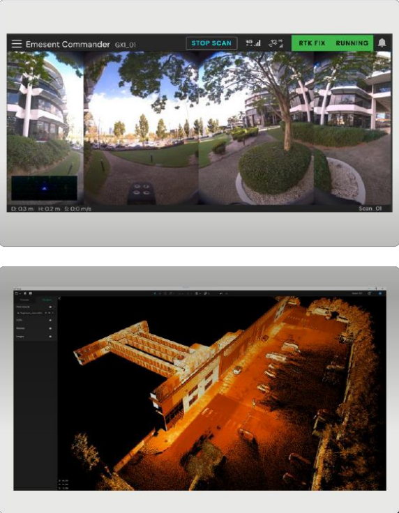
Train with Ease & Monitor in Real-Time
Designed to be "simple enough for juniors, yet powerful enough for experts," the GX1 transforms how you interact with data. Using the updated Emesent Commander app, you can configure setup, manage RTK/PPK settings, and monitor a live camera feed during the scan. Once back in the office, Emesent Aura automates the colorization and 360° image extraction in a single step, embedding high-resolution imagery directly into your E57 files for immediate use in BIM or CAD workflows.

Flexible Georeferencing
The Emesent GX1 is designed for high-stakes surveying where accuracy is non-negotiable. Featuring a premium integrated 448-channel RTK receiver, the GX1 provides a seamless workflow for georeferencing your data in real-time. For projects in remote areas or challenging GNSS environments, the system fully supports PPK (Post-Processed Kinematic) workflows. This flexibility allows you to achieve a reliable 15mm global accuracy without the need for extensive traditional survey equipment.
Simple enough for juniors.
Powerful enough for experts.

Scan
GX1 Commander

Offload
USB-C SD Card

Process
Aura

Share
Aura Cloud

Export
Trimble, Autodesk, Cintoo, Pointerra, and more...
Upcoming Software Developments
Emesent SLAM: Improved accuracy, drift and repeatability with pioneering improvements to Emesent SLAM
Commander
- Configure RTK and mobile SIM
- View live camera feed
- Toggle and configure cameras
- Mapping mode improvements
Aura
- 360-degree imagery embedded in E57 files
- Geo-reference anywhere with PPK
- Automated image masking
- Colorize and image extract in one step