3d mapping
-

Advanced Professional Development Learning Course in Understanding Multispectral UAVs
£247.00 Excl. VATLearners explore the benefits of multispectral imagery in various industries, learn mission planning techniques, examine real-world data examples, and gain insights into data processing methods. Additionally, they receive an overview of the DJI Multispectral drone and its capabilities. By the end of the course, participants will have the knowledge and skills to effectively utilise multispectral UAVs for data collection and analysis.
-
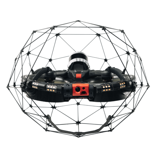
Flyability Elios 3
The Elios 3 is Flyability's advanced indoor inspection and mapping drone, designed for safety and efficiency. Equipped with the FlyAware™ SLAM engine, it offers stability and real-time 3D mapping. Its collision-resilient design and modular payload bay make it a versatile tool for various industrial applications. Benefit from enhanced data quality with its 4K camera, thermal imaging, and LiDAR data. -

Pix4Dcloud
Price range: £0.00 through £2,646.02 Excl. VATElevate your project management with Pix4Dcloud, a powerful online platform that transforms aerial imagery into custom maps and 3D models for in-depth analysis. Ideal for professionals in construction, agriculture, real estate, and more, Pix4Dcloud offers a suite of tools for tracking progress, measuring distances, and analysing changes over time.
-
Pix4Dfields
Price range: £0.00 through £3,097.35 Excl. VATPix4DFields stands out as a transformative software, harnessing the power of technology and agronomic expertise.
-
Pix4Dmatic
Price range: £0.00 through £5,831.86 Excl. VATTransform your large-scale mapping operations with Pix4Dmatic, the next-generation photogrammetry software designed for efficiency and accuracy. Built to handle the vast data sets generated by modern aerial imagery, Pix4Dmatic ensures that professionals can leverage the full potential of their hardware, turning high-resolution images into precise, georeferenced 2D maps and 3D models.
-
Pix4Dsurvey
Price range: £0.00 through £3,973.45 Excl. VATUnlock the full potential of your surveying and mapping projects with Pix4Dsurvey. Designed to bridge the gap between drone photogrammetry and traditional surveying, this powerful software transforms your point cloud data into actionable insights and detailed digital maps.
-
Ultimate Pix4DMapper Bundle
Price range: £0.00 through £5,831.86 Excl. VATTransform your large-scale mapping operations with Pix4Dmatic, the next-generation photogrammetry software designed for efficiency and accuracy. Built to handle the vast data sets generated by modern aerial imagery, Pix4Dmatic ensures that professionals can leverage the full potential of their hardware, turning high-resolution images into precise, georeferenced 2D maps and 3D models.