
Latest from Coptrz
Stay updated with the latest insights, tips, and industry news on our blog. Discover expert advice, success stories, and innovative uses of drone technology. Our blog features a diverse range of topics to keep you informed and inspired.
Latest Articles

DJI Matrice 400 vs DJI Matrice 350: Revolutionising Drone Operations with Advanced Performance and Efficiency
DJI has once again set the bar higher in enterprise drone technology with the launch of its latest flagship model—the DJI Matrice 400. This powerful platform succeeds the robust Matrice 350 RTK, offering notable advancements across multiple performance metrics, particularly designed to elevate efficiency, reliability, and productivity in commercial drone operations. Key Enhancements of DJI […]

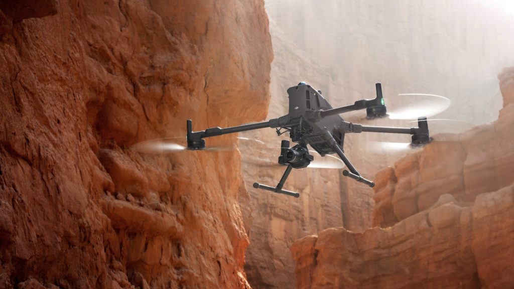
Introducing the DJI Matrice 400: The Future of Industrial Drone Operations
The DJI Matrice 400 (M400) is DJI’s most powerful enterprise drone platform to date, representing a significant leap forward in flight performance, payload flexibility, automation, and AI-assisted workflows. Engineered for demanding operations across public safety, inspection, infrastructure, and surveying, the M400 redefines the boundaries of what drones can achieve. Built for Mission-Critical Operations Whether you’re […]

Revolutionising Mapping: Emesent’s Backpack RTK – The Ultimate LiDAR Scanner for Unmatched Precision and Versatility
Overview Emesent‘s Backpack RTK, integrated with the Hovermap ST-X scanner, is designed for professionals needing high-performance LiDAR mapping. It combines real-time kinematics (RTK) and simultaneous localisation and mapping (SLAM) technologies, making it suitable for both indoor and outdoor use. This system is particularly noted for its speed, accuracy, and flexibility, which we’ll explore in detail. […]
All Posts
DJI Matrice 400 vs DJI Matrice 350: Revolutionising Drone Operations with Advanced Performance and Efficiency
DJI has once again set the bar higher in enterprise drone technology with the launch of its latest flagship model—the DJI Matrice 400. This powerful platform succeeds the robust Matrice 350 RTK, offering notable advancements across multiple performance metrics, particularly designed to elevate efficiency, reliability, and productivity in commercial drone operations. Key Enhancements of DJI […]

Introducing the DJI Matrice 400: The Future of Industrial Drone Operations
The DJI Matrice 400 (M400) is DJI’s most powerful enterprise drone platform to date, representing a significant leap forward in flight performance, payload flexibility, automation, and AI-assisted workflows. Engineered for demanding operations across public safety, inspection, infrastructure, and surveying, the M400 redefines the boundaries of what drones can achieve. Built for Mission-Critical Operations Whether you’re […]
Revolutionising Mapping: Emesent’s Backpack RTK – The Ultimate LiDAR Scanner for Unmatched Precision and Versatility
Overview Emesent‘s Backpack RTK, integrated with the Hovermap ST-X scanner, is designed for professionals needing high-performance LiDAR mapping. It combines real-time kinematics (RTK) and simultaneous localisation and mapping (SLAM) technologies, making it suitable for both indoor and outdoor use. This system is particularly noted for its speed, accuracy, and flexibility, which we’ll explore in detail. […]

Where Drones Are Saving the Most Money in 2025
In the UK today, drone adoption is delivering real ROI across industries. Recent reports show drone mapping can be hundreds of times faster than ground surveys, while swapping police helicopters for drones can cut costs ~55% (about £22.6m/yr saved). Whether it’s speeding land surveys or avoiding costly scaffolding and delays, drones are proving to be […]

The agricultural landscape is evolving, and drones are leading the charge.
Drones are revolutionising agriculture, transforming traditional practices into data-driven, precision-oriented operations. Beyond mere automation, they are becoming indispensable tools for enhancing productivity, sustainability, and profitability in farming. 1. Precision Spraying: Enhancing Efficiency and Safety Modern agricultural drones equipped with advanced spraying systems enable targeted application of fertilisers and pesticides. This precision reduces chemical usage, minimises […]

Why Drones Are Indispensable in Modern Construction
The construction industry stands at a pivotal juncture, where embracing drone technology is no longer a futuristic concept but a present-day imperative. As the sector grapples with longstanding productivity challenges, drones emerge as a transformative solution, offering unparalleled efficiency, safety, and data accuracy. 1. Accelerated Surveying and Enhanced Efficiency Traditional surveying methods are time-consuming and […]

What is the Difference Between Pix4D, Drone Deploy, and DJI Terra?
When evaluating drone mapping software, Pix4D, DroneDeploy, and DJI Terra each offer distinct advantages tailored to specific operational needs. Here’s a strategic breakdown to guide informed decision-making: Pix4D: Precision and Versatility Pix4D stands out for its high-precision outputs and broad compatibility. It supports a wide range of drones and cameras, making it ideal for professionals […]

Traditional Drone Inspections Are Failing Asset Managers — Here’s the Fix
Let’s cut through the noise. Drone inspections have come a long way. But here’s the truth: if you’re still handling data flight-by-flight, you’re not managing assets — you’re babysitting fragmented video files. And no one has time for that. Asset managers don’t want to sift through raw data. They want clear, consolidated insight into the […]

How is AI transforming UK Law Enforcement? Smarter & Safer Policing with Farsight by Reveal
AI is revolutionising public safety. From real-time video analysis to geospatial intelligence, advanced technologies are helping police forces do more with less. For UK Police, tools like Reveal Farsight are making operations faster, safer, and more cost-effective. In recent years, AI has moved from tech buzzword to practical tool in policing. Advanced algorithms now analyse […]

Enhancing Snow and Ice Research with Drone-Based Ground Penetrating Radar
In the realm of snow and ice research, traditional methods like digging snow pits for stability assessments are labor-intensive and pose safety risks. Recognising these challenges, GEORESEARCH, in collaboration with LO.LA Peak Solutions GmbH and funded by the FFG, embarked on the STRATIFY project to explore innovative approaches to snowpack analysis. The Challenge Assessing snowpack […]

Sky-High Builders: How Drones Are Reshaping the Future of Construction
The construction industry is undergoing a technological transformation, and drones are at the forefront of this change. Recent UK research, particularly from Imperial College London and the University of Bristol, is exploring how drones can revolutionise construction practices. One of the most promising developments is Aerial Additive Manufacturing (Aerial AM), where drones autonomously deposit materials […]

Drones in Civil Engineering
Drones (unmanned aerial vehicles, UAVs) have become indispensable tools in civil engineering, offering aerial access and data collection for many tasks. They are widely used to capture high-resolution imagery and sensor data, enabling precise 3D models, orthomosaic maps, and inspections that inform design, construction, and maintenance. For example, surveying drones equipped with high-res cameras and […]


