Stockpile measurements are vital for sectors ranging from construction and mining to agriculture. They offer insights into the volume of materials on-site, assisting in inventory management, purchasing decisions, and understanding the value of a site. Traditionally, these measurements were taken manually, which was time-consuming and posed safety risks. With the advent of drone technology, stockpile measurements have become more precise, efficient, and safe.
Stockpile Measurements with Drones
Drones have revolutionised the way stockpile measurements are taken. They offer a bird’s-eye view of the site, capturing detailed images that can be processed to calculate volumes with high precision. The steps involved in drone stockpile measurement include:
Determining the right hardware:
- Image Clarity Superior optics and a large sensor in the camera ensure clear images. A higher megapixel count can enhance clarity, but it’s not the only factor.
- Data Accuracy Using a GNSS receiver, drones can connect to more satellites for improved precision. With RTK processing, consistent data alignment over time is achieved, vital for monitoring ever-changing stockpiles. Without RTK or GCPs, maps may shift multiple feet, leading to inaccurate stockpile measurements, especially when comparing data from different dates.
- Creating a mission Automated flight routes are planned using mapping software for comprehensive site coverage.
- Processing data in DJI Terra Images are processed using DJI Terra’s powerful photogrammetry engine.
- Analysing stockpiles DJI Terra tools allow for annotation and volume calculation of stockpiles.
- Exporting data Processed data can be exported in various formats to suit different software platforms.
Hardware
The choice of drone hardware is crucial for accurate stockpile measurements. Factors to consider include:
- Image clarity Achieved through a high-quality camera with a large sensor, mechanical shutter, and high-grade optics.
- Data accuracy Drones with GNSS receivers and RTK processing offer higher precision.
- Site-specific requirements Depending on the size and environment of the site, drones with longer flight times, higher IP ratings, or swappable payloads might be needed.
The DJI Mavic 3 Enterprise is a popular choice for many clients, offering a balance of image quality, precision, and affordability. For larger or more challenging sites, the DJI Matrice 350 RTK and Zenmuse P1 are ideal.
Mission Creation
Automated flights are recommended for stockpile calculations as they ensure consistent and accurate data collection. With mapping missions, you can reduce human error, streamline operations, and provide comprehensive coverage of the entire stockpile area.
To use mission planing on the DJI Mavic 3 Enterprise, follow these steps:
- Launch the DJI Pilot 2 app on your controller and select the Flight Route option.
- Choose ‘Create a Route’ and then select the ‘Mapping’ option.
- Zoom into your site (ensure the controller is connected to the internet).
- Select the Camera, and an automated flight route will be generated. Adjust the white dots on the polygon to cover your desired area.
- Set the flight altitude (around 250 feet AGL is recommended for stockpiles).
- Adjust other settings as needed, such as turning off Smart Oblique and toggling on Terrain Follow for sites with significant terrain changes.
- Elevation optimisation should be turned off. You can capture only NADIR imagery for stockpile analysis.
- Under the Advanced Settings you can change the Side Overlap and Front Overlap, we recommend leaving the defaults set (70% sidelap and 80% frontlap).
- Save the mission and then initiate it. Adjust camera settings as required, ensuring a minimum shutter speed of 1/1000 to minimise motion blur.


Processing Data in DJI Terra
DJI Terra stands out as the go-to software for processing drone-captured data. It offers a user-friendly interface, powerful tools for annotation and measurement, and the ability to export data in various formats. Its capabilities ensure that stockpile measurements are accurate and actionable.
- After capturing the site data, transfer it to your computer.
- Launch DJI Terra and select ‘New Mission’ under the Reconstruction tab.
- Import the imagery by selecting the Folder icon. The software will display the image locations.
- If Ground Control Points or Checkpoints were used on-site, utilise the GCP Management tool to tag these markers.
- Activate both 2D Map and 3D Map options and select the desired file types for export.
- Click on ‘Run Reconstruction’ to process the data.

Analysing Stockpiles in DJI Terra
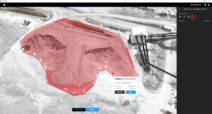
Using DJI Terra, stockpiles can be analysed in detail. Annotations and measurements tools allow users to drop pins, measure distances, and calculate volumes. The software provides both cut and fill volumes, and users can choose between different base planes for calculations.
- Use the Annotation and Measurement tool to drop pins, measure distances, and calculate volumes.
- To measure a stockpile, select the Volume tool and outline the stockpile. DJI Terra will automatically calculate its volume.
- Annotations can be exported as a single xlsx sheet containing Annotation Name, Base Plane used, Cut and Fill values.
You can also adjust the Base Plane using two available options:
- Mean Plane: This method determines the base of the pile by averaging the elevation throughout the annotated area. It’s the suggested setting for the majority of stockpiles and offers the highest accuracy for standalone piles.
- Lowest Point: This is ideal for stockpiles situated in bunkers or against walls. It sets the base plane according to the stockpile’s lowest elevation point, accommodating for situations where the back of a bunker isn’t measurable.

Exporting
DJI Terra supports exporting data in various formats, catering to different software platforms. Common export options include Tiff images for 2D data and las files for 3D point clouds. To export, return to the Home screen, highlight your project, and select the ‘Export’ option. Choose the data layers you wish to export.
LWW Engineering, in collaboration with Coptrz, showcased the power of drone technology in stockpile measurements. Using the DJI Mavic 3 Enterprise, they captured a centimetre-accurate dataset in just 14 minutes. This data was processed in DJI Terra in a mere 2 hours. LWW Engineering’s use of drones for everything from basic surveys to intricate 3D modelling underscores the transformative impact of this technology. You can explore a 3D model of one of their stockpiles and see how the technology works for yourself.
Before Drones
Before the advent of drones, stockpile measurements were manual, involving physical measurements on the ground. This method was not only time-consuming and less accurate, but it also posed safety risks. With drones, measurements are quicker, safer, and more accurate, highlighting the efficiency and advantages of drone technology.
Drones have undeniably revolutionised stockpile measurements, offering unparalleled accuracy and efficiency. Whether you’re in construction, mining, or agriculture, leveraging drone technology can significantly enhance your operations. If you’re interested in exploring the potential of drones for your business, we encourage you to reach out and discover the possibilities.
Download Our FREE RPC-L1 Guide
Understand everything you need to know about moving towards commercial drone operations with our RPC-L1 guide.
- Understand what RPC-L1 is and who it is for
- Learn how the CAA transition impacts operators and training routes
- Get a clear breakdown of requirements, costs and next steps


Related Posts
Revisiting the DJI Matrice 300 RTK – Is it still the best drone for Public Safety?
10 minute read Drone technology has grown rapidly in recent years, with several new releases from top commercial manufacturers such as Parrot, Autel, Sesnsefly, and more. Yet even two years on from its launch, the DJI Matrice 300 RTK has still remained at the top of its class. With impressive features such as a 55-minute flight time, […]

The State of UAVs in the UK, Part 2 – Stadiums
Anyone who has ever been to a stadium to watch a football match or their favourite band must have wondered what would happen if there was a sudden cause for panic. For a stadium manager, this is a nightmare scenario which keeps them awake at night. There is an endless list of situations which could […]
COPTRZ News: Federal Aviation Administration Announce New Drone Restrictions
At the request of the Department of Defence, the Federal Aviation Administration (FAA) have announced new drone restriction measures. The measures are being put in place to address the potential threat that is posed by malicious drone operations. Their intention is to establish drone specific airspace restrictions over select, national security sensitive locations. What’s changing? […]















