Woodland Management – How Can Drones Help?
Most people know drones as handy, hovering cameras that can be used to take some amazing scenic snaps. But in reality, drones can do so much more. They’ve been helping the world out hugely during the COVID-19 crisis, providing people with everything from shopping to aiding with social distancing. But how can they help with Woodland Management?
In this Blog you will learn;
- The importance of Woodland Management
- Drone applications in Woodland Management
- Woodland Management case study
- Drones and the English Ash
- Drone Safety in Woodlands
If you would like advice on how to incorporate drones into your operations, please get in touch here.
Drones can help with pressing global issues that are facing today’s generation; one of which is protecting the environment. Climate change is predicted to affect us enormously in the next few decades, and many people nowadays are taking all the steps that they can to prevent it.
While a lot of the environmental changes are due to modernisation, technology can also be used to help the environment. Drones are a key example.
Wildlife conservation drones are no new thing. They are used throughout the world to monitor animal behaviour and other changes in the natural environment year on year.
Many people who are interested in getting into wildlife conservation look for destinations that are famous for their flora and fauna. The African Savannah or the rainforests of South America immediately spring to mind. However, right here in the UK there are plenty of ways to use drone surveillance to help conserve nature and wildlife.
In the UK, we have Sites of Specific Scientific Interest, or SSSIs. These are crucially important places to analyse plant and animal behaviour and discover how they benefit the ecosystem. Our ecosystems are in a delicate position – losing even one species could be detrimental – so it’s really important to have a good idea of where different species are found and how we can monitor them.
Monitoring the woodlands
It’s difficult to monitor different species of animals and plants in British woodlands from ground level. Therefore, using drones for surveying can be really beneficial to see the movement patterns of certain animals, as well as photographing damage and more. Using drones regularly to keep track of wildlife is hugely beneficial when analysing wildlife patterns.
In Bentley Wood, an SSSI on the border of Wiltshire and Hampshire, drones have been used successfully to track butterflies and moths. These species have been in decline in recent years due to people cutting back branches, and subsequently removing the habitat of butterflies and moths. These insects are important in the ecosystem as they act as food for larger animals, and moths can pollinate flowers. Therefore, losing the species either in an SSSI or anywhere else in the country would be very damaging.
Drones are flown in the woodland, around trees and in areas that are difficult to observe in person. Photos are then taken and reported.
These drones have been very successful in discovering the areas where most butterflies and moths are living and marking these as areas that should be untouched. Once an area is designated as such, it can be fenced off from the general public, or it can be made illegal to cut branches there. This protects many more creatures and will help them to thrive in years to come.
Planting trees
Trees are known as the ‘lungs’ of our planet, and everyone knows their importance – they produce oxygen which is required for us all to live, after all! However, they are being chopped down at an alarming rate. Estimates say that 3.5 to 7 billion trees are cut down each year to make room for development and livestock. This is a considerable amount, something which environmentalists have been campaigning against for years.
Luckily, there are plenty of initiatives that are planting more trees throughout the world, including many in the UK. However, it’s sometimes difficult to know exactly where to plant them from just observing at ground level. It can be challenging to assess exactly how the tree will look when grown, and if it will fit into the forest at all stages of its growth. It’s also important to consider what other plants in the forest are doing and whether they will change as the tree goes.
This is where drones come in. Quite simply, they can survey woodland and find open spots, which can be geotagged, and trees can be arranged to be planted in these specific plots.
In some instances, clearings for artificial pools of water can also be pinpointed by drone research. Artificial pools of water are crucial in some places to provide the local fauna with somewhere to drink and to introduce a damper climate into the environment.

Protecting ash trees
Ash trees are probably facing the worst predicament of all tree life across the country. There has been a large decline of ash trees across the UK – with even more of a demise predicted across the next few decades.
This is due to a fungal disease called Chalara, or ‘ash dieback’, which spreads as the fungal pores of a diseased tree get scattered in the wind and latch onto other trees in the vicinity. The disease can easily travel between tree canopies, which are interlocked closely in many forested areas. This is fatal for young trees, and while not instantly fatal for older trees, does prove to kill them after a few seasons of contracting the disease. A staggering 90% of ash trees are expected to be affected by ash dieback.
Why are ash trees important?
It’s vital that we do everything we can to protect our ash trees, as they are really important to the biosphere of forests. Ash trees have loose branches, meaning that lots of light can go through the gaps in the canopy to reach the forest floor. This gives plants the opportunity to grow here, potentially in places where they wouldn’t otherwise. These plants, in turn, are food for herbivores in the food chain.
The ash tree itself has alkaline bark, which isn’t the case for many trees, so it is home to 60 of the rarest insect species in Britain. Without ash trees, these species wouldn’t have a home, which would provide further challenges to the forest ecosystem.
The ash tree is the third most common tree in the UK, and some forests are made up nearly wholly of ash trees. If an ash dieback outbreak was to occur there, the consequences would be devastating. That’s why it’s really important to keep surveillance going in all areas of the country to monitor what could happen in the future.
Ash trees also have a cultural value, having made it into historic texts and art throughout the centuries of British history. Therefore, protecting these species and not letting them become extinct is also important for heritage reasons.
Finding outbreaks of ash dieback
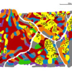
The first step to protecting our ash trees is finding outbreaks of Chalara. Then it can be managed and surveyed. There are very limited ways of assessing this on ground level – as it mainly affects the canopies, it’s really important to be able to get a picture from a bird’s eye view and be able to see the different spots of the canopy.
Once again, the usefulness of the birds-eye view that drones provide really comes into play. They can be used to take multiple pictures to track Chalara spread. This gives vital research to see where Chalara outbreaks are occurring and assess what to do about them. While it’s difficult to section off trees in woodland and prevent them from getting dieback, it’s important to know how likely a tree is to succumb to Chalara and how many more trees should be planted to replace those that are affected.
People can also use drones to monitor for future issues by keeping forests under constant surveillance in real-time. Some drone technologies with AI and infrared can stay in the air for longer and give a much more detailed picture of the trees below.
This was done successfully in Reach Wood. This area is one of the least wooded areas of Cambridgeshire, and if its trees were to die, the consequences could be severe. Using aerial drone photography, volunteers at Reach Wood identified which ash trees were dying of Chalara; finding 163 in the summer of 2018. They managed to assess the risk of dieback in their wood and clarified an action plan. Reach Wood was not as affected as other parts of the UK might be through ash dieback, because the wood has many many other species. However, they were only really able to assess this through drone photography.
Planting ash trees
It has been discovered that the soil improver biochar may be a remedy for ash dieback. Climate Friendly Bradford on Avon discovered that the trees that they planted with biochar seemed to be resilient to dieback, whereas those without biochar were. This was a really interesting discovery that is paving the way for future ash tree planting.
As drones are used both to find outbreaks to prepare for the future and to designate spaces for potential trees to be planted, they are crucial in both stages of this process. It is near impossible to find outbreaks of dieback without a drone – before the widespread use of drone surveillance, most people just waited for ash trees to die – and difficult to accurately gauge where they should be planted from ground level.
There is, unfortunately, no known cure for ash dieback once it is infected – but keeping track of the infections and being able to plant ash trees is a good alternative. It is recommended to plant ash trees using the 3/2/1 method – plant 3 trees to replace a big tree, 2 for a medium tree, and 1 for a small tree. Again, drones can be used to ensure that the spot is big enough to accommodate two or three trees, as it may need to be substantially bigger than the spot where the ash tree was before.

General surveillance
When protecting any kind of area, particularly SSSIs, it helps to have a database of images to look back on. Plants don’t grow quickly – some gradually move within a few months, and others take years to develop. While we often don’t have years of photos to look back on, we can start using drones now to monitor and make it easier for generations to come.
Safety when using a drone in the forest
It is often up to the forest protection association to give the go-ahead to use a drone. If it is private land, drone usage may not be permitted. Furthermore, the association may want to give people living around the forest ample warning that there will be surveillance in the area.
Therefore, if you live near a forest and want to take steps to protect it with drones, it’s important to contact the local authorities or a protection association to see what the technicalities would be when using a drone there.
It’s also important that an person operating a drone is trained to do so – Coptrz offers a full range of solutions that you can view here.
It goes without saying to be careful of the trees; some drones, like the new DJIs, that are equipped with good infrared and AI should be able to avoid them, but many drones have been lost to trees before – so it’s important to make sure that your drone is up to the challenge!
Conclusion
Drones are really handy pieces of equipment to assist the UK’s woodland management. They aren’t very expensive when it comes to surveillance technology and are relatively easy to operate.
They can really help flora and fauna species to survive, and subsequently, drones can help us to protect the wider ecosystem. They are great for surveilling the tree canopy to monitor for ash dieback and other diseases, to find empty spots that could accommodate new trees, and to monitor wildlife habitat and migration.
They are also crucial when planning for the future – constant surveillance helps us to get a clear picture of what the animals and plants might be doing in a few years. As the climate crisis is impending, we should be doing all we can; as such, it’s vital to track the progress and decline of woodland areas before we lose them.
Download Our FREE RPC-L1 Guide
Understand everything you need to know about moving towards commercial drone operations with our RPC-L1 guide.
- Understand what RPC-L1 is and who it is for
- Learn how the CAA transition impacts operators and training routes
- Get a clear breakdown of requirements, costs and next steps


Related Posts
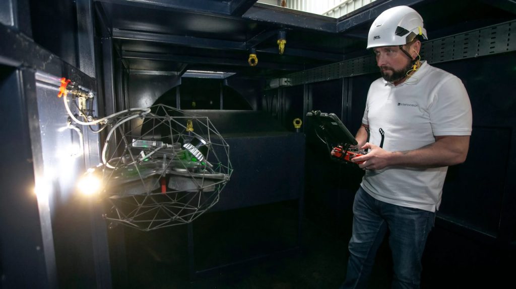
Class Certification for Maritime Drone Inspections with the Elios 3
How Interocean is leading the way with Class-Certified Drone inspections At Coptrz, we’re proud to be the exclusive UK provider of the Flyability Elios series—revolutionary drones that are redefining how industrial inspections are carried out. One of our valued customers, Interocean Marine Services, has been at the forefront of this transformation, leveraging drone technology to […]

The CAA are Trialing a Drone Sky HighWay THIS YEAR
It’s like a scene straight from a blockbuster movie: drones taking flight to deliver life-saving medical supplies, or saving people stuck in natural disasters. This year, the Civil Aviation Authority (CAA) has stepped onto the director’s chair, orchestrating a step towards innovation through Beyond Visual Line of Sight (BVLOS) drone operation trials. It feels even […]
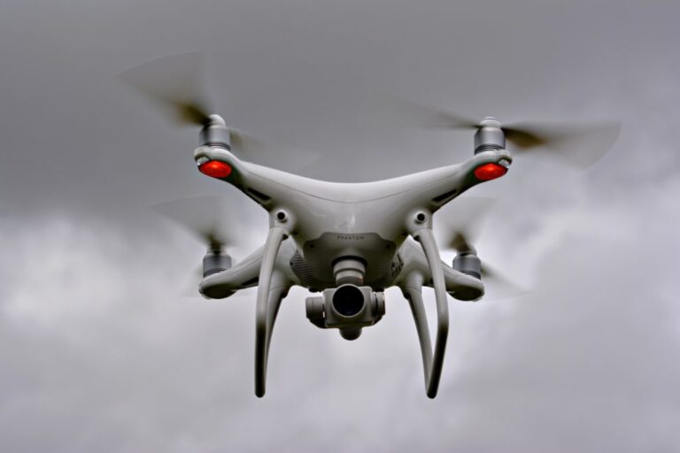
Drone Business Startup: DJI Phantom 4 or DJI Mavic Pro?
When it comes to starting up a drone business, naturally, the biggest decision you will make is what drone you fly. This, for the coming years, is what will drive (or fly) your business towards success. So, with that in mind, it’s imperative that you make the right choice from the offset. In this blog, […]