

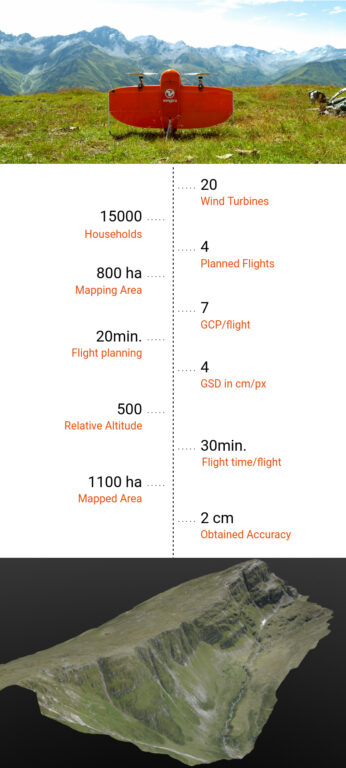
At a lofty altitude of 2500m above sea level, 20 wind turbines of 100m height are to be built. These wind turbines will produce 60 GWh per year to power 15,000 households. The challenge, however, is twofold. With the construction site in the middle of the mountains, there are no roads to access it. Nor are there any pre-existing detailed data for site planning of the wind park itself, which is 800 ha large.
This is the challenge Cavigelli Ingenieure AG faced in the Swiss Alpine valley of Lumnezia. While mapping and 3D modelling of large areas with high accuracy is a routine challenge in Geospatial applications. The hilly terrain, high altitude and fast-changing conditions in the mountains brought additional constraints. Keeping in mind the need for flexibility and low cost, the company turned to drone use.
Drone use in Geospatial applications
Cavigelli is not alone in its decision to use a drone for data collection. The surveying industry has in fact been one of the early adopters of drone use and continues to be an avid user today. Engineers looking at commercial drone solutions face dilemmas: difficult terrains and limited spaces necessitate the use of multirotors. However, commercial multirotors – quadcopters and hexacopters – are also limited in their area coverage. These drones tend to be inefficient in flight. Popular quadcopters can only cover an area of 40 ha in 25 minutes, for example.
On the other hand, though fixed-wings can fly longer and cover more area. They also complicate flight planning as fixed-wings need wide open areas for take-off and landing. As sensors can often get damaged during belly landings of fixed-wings, these drones typically carry inferior sensors compared to multirotors.
This gap between usability, long range, and survey-grade imagery is what the Swiss drone company Wingtra aims to bridge. Introduced earlier this year, their VTOL drone Wingtra takes off and lands vertically like a multirotor. It also tilts forward in flight to fly like a fixed-wing aircraft. Combining this with the capability to carry heavy sensors means that the Wingtra can cover areas as large as 400ha. This is equivalent to 570 football fields – in a single flight of 55 minutes*.
Collecting Aerial Imagery in the Heart of Swiss Alps
This combination – VTOL capabilities to navigate through hilly terrain along with long flight range and accurate imagery. This is exactly what the engineers at Cavigelli were looking for. For this particular application, they chose a Wingtra with the full frame 42MP Sony RX1RII, after which they set out to collect aerial data.
The crew started the day with a 1-hour hike to the site and planned 4 flights on site to take into account environmental challenges. All flights were planned at 500m relative altitude, with a GSD of 3.5-4.5 cm/px. The engineers also used 7 Ground Control Points per flight for better accuracy. Each flight took up to 20 minutes of planning and 30 minutes of flying time. Together, these flights covered an area of 1100 ha, 200-300 ha per flight.
Turning information into insight
Finally, the aerial data that was collected from the site was converted to 3D Models. This allowed visualization of planned roads and wind turbines in the Wind Mill park. The entire data collection workflow itself took a mere 4 hours with the WingtraOne – a process that could easily take days with traditional surveying methods. Use of high-end sensors ensure survey grade imagery and accuracy – in this particular example, the engineers obtained an accuracy of 3-4cm.
“The transport, the flight preparation, the flight planning, the takeoff process and the data transfer were very easy and convincing,” says Thomas Arpagaus, an engineer at Cavigelli. “The aerial survey has shown that it takes only a very short introduction/training for a successful completion of a project. For the implementation of the flight planning, the user is accompanied by the menu in a very structured way. The subsequent aerial photographs work (almost) completely automatically. The process has convinced me!”
About Wingtra
While Wingtra made its market entry earlier this year and is already in use for various Geospatial applications in Europe, US, China and Australia, Wingtra’s origin lies in a research project at ETH Zurich 3 years ago. Wingtra has since grown to a 40 people strong team of engineers, creatives, and business professionals. Believing that data fuels the 21st century, it’s Wingtra’s mission to give people the tool to extract it easily, accurately and efficiently. And if projects like these are any indications, Wingtra is well on its way to fulfilling its mission.
As Arpagaus added, “Thanks to the use of a drone, we were able to greatly reduce the costs for the surveying and evaluation of the original site for the design work. The tight project planning could be kept due to the fast and flexible data acquisition with the WingraOne.”
Collecting aerial data in an area as constrained as the Swiss Alps was one of the most complicated challenges that Wingtra undertook recently. Encouraged by its success, Wingtra continues to pave the way for innovative, long-term solutions that work in harmony with various established industries. This adds great value to applications that might be far removed from drone use at first glance.
Wingtra PPK is available directly through COPTRZ. Click here to find out more and request a quote.
Download Our FREE RPC-L1 Guide
Understand everything you need to know about moving towards commercial drone operations with our RPC-L1 guide.
- Understand what RPC-L1 is and who it is for
- Learn how the CAA transition impacts operators and training routes
- Get a clear breakdown of requirements, costs and next steps


Related Posts

Flyability Launch Asset Management Software Extension
Navigating the complexities of raw drone data without an effective management solution can make it difficult to use the information effectively. This often leads to imprecise reporting, indecisive actions, and, ultimately, sub-optimal maintenance efforts. Building upon the groundwork laid by Inspector 4, Inspector 5’s Asset Management Extension enhances asset management by integrating data from numerous […]
What is an A2 CofC (Certificate of Competency), and why do I need one?
A2 CofC – Drone Training Course If you didn’t know already, the drone laws in the UK changed on the 31st of December 2020. The new drone regulations can be confusing to get your head around what has changed, fear not…Coptrz have got you covered. We are here to support you through these changes and […]

DJI Inspire 2: The Review
Although DJI’s next-generation craft may have one eye on Hollywood, the Inspire 2 is set to become a major player in many commercial field. Keep reading for the full DJI Inspire 2 review, written by Ian Collen of DRONE magazine. It has barely been a couple of years since the original Inspire was launched in November 2014, […]


