The drone inspection market is booming, driven by advancements in technology that are constantly creating new applications. And 2024 is shaping up to be another year of significant growth. Drone technology is becoming more accessible and affordable than ever, with a wider range of options available than ever before. To help you navigate this evolving landscape, we’ve compiled a list of the top drones for inspection tasks in 2024.
Inspections remain one of the most popular applications for drone technology. From confined spaces and sewers to hazardous environments, drones are transforming the way inspections are conducted. Here at Coptrz, we’ve continued to help businesses like Severn Trent Water, Texo, Networx3 leverage drone technology to enhance their operations and achieve greater efficiency.
Now let’s get stuck into what you came for:
We’ll take you through the following in this article:
- How drones are transforming inspection processes
- The benefits of drone inspection
- How using drones for inspections reduces costs
- Applications of drone inspection
- Drone inspection cost versus traditional inspection cost
- Our top 6 drones for inspection in 2024
How are drones transforming the inspection process?
Drones are being increasingly used in almost every industry that requires visual inspections as part of its maintenance, production and service procedures.
At the heart of this revolution lies the simple principle of using a drone’s camera as an extension of the inspector’s eyes. By capturing high-resolution visual data of assets, even in hard-to-reach or dangerous areas, drones enable detailed evaluation without risk to human inspectors.
But the power of drones goes beyond just visuals. For example, thermal cameras can identify heat leaking from a building or be used to locate people. Multispectral sensors are used in agriculture and enable farmers to record images of crops to analyse their state.
While drones are undoubtedly valuable additions to the inspector’s toolbox, you should not get our messaging confused. Drones will never replace the human inspectors. However, it is crucial to understand that the safest and most efficient approach involves combining both, leveraging drones for a comprehensive 3D overview followed by targeted close-up inspections.
Here are some of the key reasons why drones are transforming inspections across industries:
- Safety: Inspecting high-rise structures, confined spaces, or hazardous environments becomes significantly safer with drones.
- Efficiency: Drones cover large areas quickly and thoroughly, reducing inspection time and costs.
- Data Capture: High-resolution imagery and sensor data provide valuable insights for informed decision-making.
- Accessibility: Drones reach previously inaccessible areas, ensuring complete and detailed inspections.
So, whether you’re inspecting bridges, wind turbines, pipelines, or agricultural fields, consider adding drones to your toolbox. They’re not just the future of inspections – they’re already revolutionising the way we see and assess our world.
Connor Mullan, UAS Pilot for Texo, commented “The Elios 3 is excellent for managing tough environments with GPS shadowing, or is simply too tight for other drones to access. It’s a caged system that uses LiDAR for its positioning, allowing you to get close to your assets without the need to put people at risk of working at height or in confined spaces”.

Using drones to carry out inspections can keep inspector safe by removing the need for them to enter potentially dangerous scenarios, for example climbing towers or high scaffolding.
Traditional maintenance strategies often adopt a reactive approach, waiting until assets fail before initiating repairs. This reactive mindset can lead to significant financial and time expenditures on repairs that could have been avoided, disrupting routine operations with unplanned maintenance demands.
In contrast, implementing more frequent inspections can facilitate early problem detection, thereby reducing repair costs and extending asset lifespan. There’s an increasing emphasis on leveraging innovative monitoring techniques that go beyond conventional on-site visits. Transitioning to remote inspection and data analysis methods enables more consistent and insightful assessments. Such a shift not only enhances resource allocation but also minimises unnecessary asset failures by prioritising interventions based on accurate data.
Challenges like wear, corrosion, and damage from environmental factors pose substantial risks to asset management, including safety hazards, operational interruptions, and unexpected repair expenses. Maintaining precise information on asset conditions is essential for strategic planning and investment. Furthermore, when repairs are necessary, the ability to deploy technicians or specialists efficiently highlights the importance of effective resource management and the strategic use of staff expertise.
The adoption of remote sensing and careful monitoring practices marks a significant move towards more efficient operations and resource management. By ensuring timely and effective interventions, such strategies play a crucial role in maintaining asset integrity and operational efficiency, thus offering a sustainable approach to asset management.
This is important because building scaffolding to allow a person to perform a manual inspection is generally expensive and a timely process. By only building scaffolding when there is a need to perform maintenance, companies can reduce their expenses which results in saving money.
Organisations and their drone operators benefit from both previously unavailable levels of visibility and lower cost by utilising UAVs rather than traditional human, airplane or helicopter methods. Using drones offers improved worker protection and access to information on assets in many dynamic and challenging industries.
At the end of the day, if you’re still inspecting your assets with rope access, then you really need to be considering the impact that drones will have on the safety, speed and cost savings.
George Burne, our business development manager for the inspection industry, is ready to get you started on your drone journey.
George has enhanced business performance in organisations like Severn Trent Water, IRISNDT and TEXO by providing a complete drone solution. George’s expertise lies in increasing business efficiency by using a drone solution where possible as well as traditional inspection methods. Key clients report project times are now counted in days rather than weeks, the quality of the data is much higher, and smaller crews are required to carry out the inspection.
How can using drones for inspection reduce costs?
Inspections are simply a part of the maintenance or performance monitoring processes in industrial, commercial and agricultural environments. Most often, perhaps as much as 80% of the time, inspections will find no problem that requires fixing. That makes inspections an inefficient process when sending a human inspector to undertake the work.
Drone inspections can enormously reduce costs and offer significant returns on investment. By using a drone to collect visual, real-time and recorded data on the condition of an asset, UAV inspections help inspectors avoid having to place themselves in dangerous situations. By significantly reducing the amount of time personnel are placed in hazardous situations, companies can also reduce their corresponding liability insurance costs.
Given the relatively low cost of drone inspections, many companies are using them to perform inspections more regularly, which means that potential problems can be surfaced and addressed more quickly. Drone data represents a meticulous record of the condition of an asset over time. By collecting and archiving visual data, companies have a digital footprint of the asset’s life history that can be accessed at any time.
Not only that, software now exists that allows transfer of data from the drones and the creation of reports to send to key stakeholders possible on the same day. See how Pix4Dcloud enables you to easily share data with annotations to your clients.

Applications of Drone Inspection
The environments which benefit from drone inspections are wide-ranging and ever-expanding. But, in particular, include agriculture, chemicals industries, in construction, infrastructure and utilities sectors, the insurance industry, mining, oil and gas. Here’s a breakdown of how drones are being used across a few of these industries:
Infrastructure Inspection:
- Bridges and Buildings: Drones capture high-resolution images and videos of cracks, corrosion, and other damage on bridges, buildings, and other structures, improving safety and reducing the need for risky manned inspections.
- Power Lines and Wind Turbines: Drones safely inspect extensive power lines and wind turbines for damage, potential hazards, and maintenance needs, reducing downtime and costs.
- Oil and Gas Pipelines: Drones navigate remote and challenging terrain to inspect pipelines for leaks, corrosion, and potential security threats, enhancing safety and environmental protection.
Environmental Monitoring:
- Solar Farms: Drones assess the performance of solar panels, identify damaged or malfunctioning units, and map vegetation growth, optimising panel cleaning and maintenance schedules.
- Agricultural Fields: Drones monitor crop health, detect pests and diseases, and analyze soil conditions, enabling targeted interventions and resource optimisation for sustainable agriculture.
- Forestry Management: Drones map forest areas, monitor tree health, and identify potential fire risks, assisting in sustainable forest management and fire prevention efforts.
Construction and Engineering:
- Site Progress Monitoring: Drones capture accurate aerial maps and 3D models of construction sites, tracking progress, identifying potential issues, and improving communication between stakeholders.
- Roof Inspections: Drones safely inspect roofs for damage, missing tiles, and potential leaks, eliminating the need for risky climbing and scaffolding.
- Mapping and Surveying: Drones map large areas quickly and accurately, assisting in land surveys, topographic mapping, and infrastructure planning.
Want to find out more? Download our Drones for inspection guide, which takes you through everything you need to know! – Get your free copy here!
Drone inspection cost versus traditional inspection cost
There are numerous examples of specific applications where drones have delivered considerable efficiencies compared with traditional inspection methods. Take a look at these two:
1) According to research carried out by the UK Drone Safety Register on a specific example of inspections in the construction industry, savings achieved by utilising a drone can be anywhere between 70 and 85 per cent. For example, they concluded that the total cost of erecting scaffolding to perform a roof inspection would be £1,250. Using an elevated platform would cost £1,050. Yet the cost of deploying a drone would be around £500.
2) When West Sussex Council commissioned Balfour Beatty to trial bridge inspection work using drones, the result was a direct saving of £8,000 per inspection. Not only that, but using a UAV reduced disruption and inconvenience to the public and road users, and lowered potential health and safety risks.
So, what are the Top Drones for Inspection in 2024?
Let’s get stuck into what we believe will take your inspections to the next level this year:
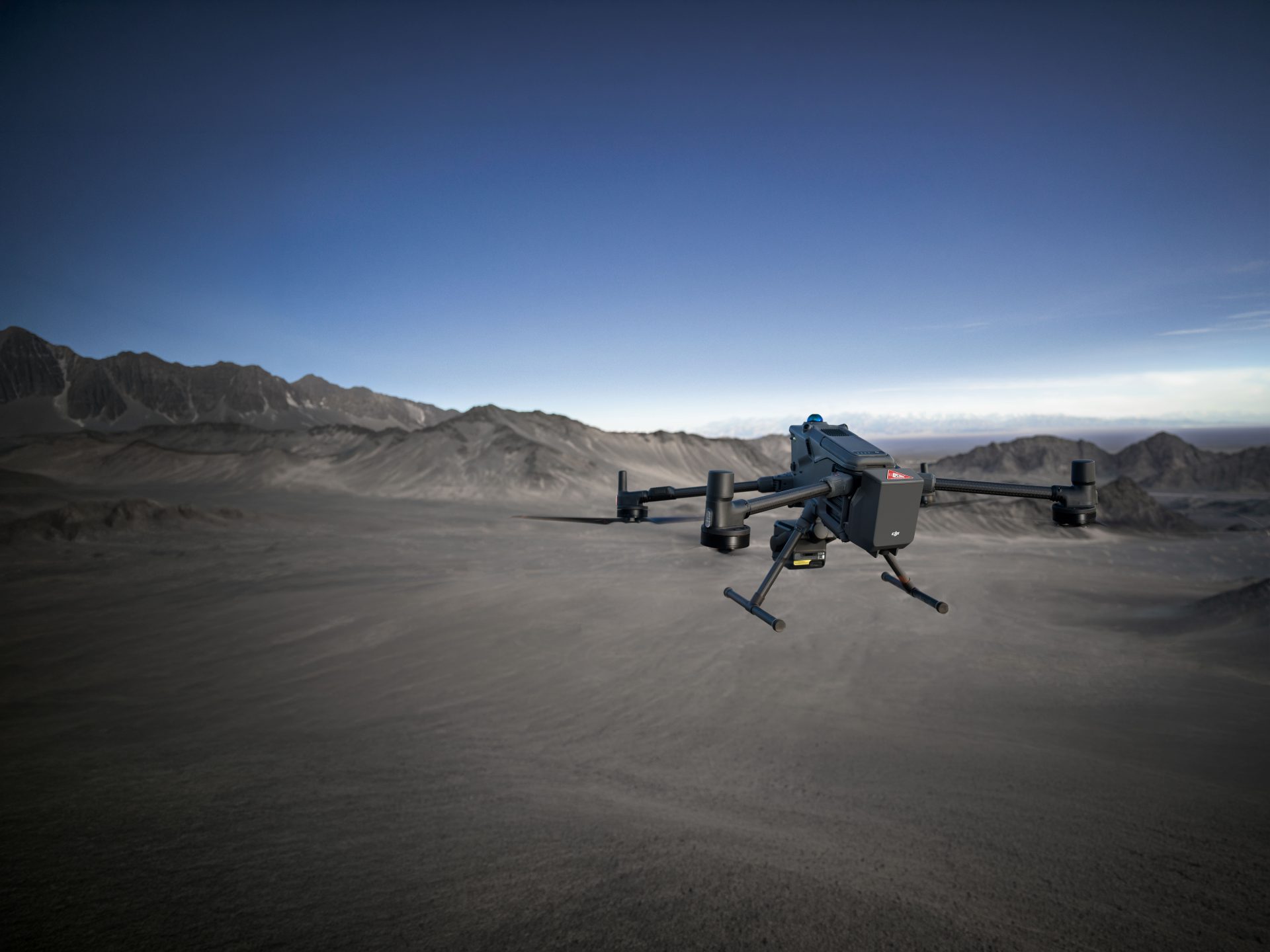
DJI Matrice 350 RTK
The M350 is the most intelligent and versatile drone on the market. Paired with the DJI Zenmuse H20 series, it offers up to 55 minutes of flight time, advanced AI capabilities, 6 Directional Sensing & Positioning and more.
Possibly one of the biggest standout features of the M350 is the advanced payload capacity and gimbal configuration. You can add up to three sensors, two down, one up, with a maximum combined weight of 2.7kg. And this isn’t just limited to DJI payloads. You can also connect 3rd party payloads for unprecedented flexibility. View our payloads here.
The M350 can fly for almost an hour unencumbered with a payload. At full capacity and weighing 9kg, you’ll still get 31 minutes before you need to change your batteries. For a commercial drone this is huge.
Flyability Elios 3
For internal inspections, it’s no secret that the ELIOS 3is the market leader. The ELIOS 3 is designed especially for confined spaces, fitted with robust transmission, collusion resilience and confined space accessibility.
Building on the success of the Elios 2, the Elios 3 was engineered to reduce downtime, improve safety and lower the cost of industrial inspection, making it one of the most esteemed pieces of kit in the inspection industry.
Without a payload carrying any additional weight, the ELIOS 3 is able to capture both visual and thermal data. You can rest assured that, even in low light situation, the Elios 3 will still get the job done with a new 16,000 lumen lighting system.
But what really makes the Elios 3 stand out is its additional it’s powerful LiDAR sensor that unlocks a whole new level of data acquisition in confined spaces. Unlike a camera that captures flat images, the LiDAR sensor on the Elios 3 emits laser pulses and measures the reflected light to create highly detailed 3D models of its surroundings. This allows you to accurately map complex geometries, measure volumes, and identify potential issues in ways that traditional cameras simply can’t.
Watch our review of the Elios 3 here!
Parrot ANAFI Ai
The Parrot ANAFI Ai is the latest UAV from french drone manufacturer Parrot and is set to revolutionise the way you carry out your inspections.
The Parrot ANAFI Ai is designed to make your missions quicker, faster and safer. The 4G Connectivity, 48mp Camera that can rotate 90 degree upwards and the game-changing Obstacle Avoidance software are just some of the key features that will make your more complex missions run smoother.
ANAFI Ai saves you time by reducing the number of overlap flights through a wider field of view and 1.5x higher altitude achieved by its 48MP sensor, allowing the ANAFI Ai to fly 2x quicker than any other drone on the market.
ANAFI Ai’s uniquely designed obstacle-avoidance (OA) system detects obstacles in all directions, using stereo cameras to sense objects and automatically avoid them. ANAFI Ai automatically determines the best trajectory to pursue its mission.
DJI Mavic 3 Thermal
The DJI Mavic 3 Thermal isn’t just another drone; it’s a powerful aerial inspection tool equipped with a dual-imaging system that unlocks the invisible world of thermal data. Here’s how the Mavic 3 Thermal can revolutionize your approach to inspections:
Capture high-resolution images and videos with the 48MP wide camera, then reveal hidden insights with the integrated 640x512px resolution thermal camera. Detect temperature variations, identify potential issues, and gain a comprehensive understanding of your inspection site.
Point and area temperature measurement, high-temperature alerts, and customisable colour palettes deliver precise data interpretation. Quickly identify anomalies and make informed decisions in real-time.
Enjoy a maximum flight time of up to 45 minutes, covering large areas efficiently. The compact and portable design makes it easy to deploy, while the omnidirectional obstacle avoidance and advanced return-to-home features ensure safe and reliable operation.
Enhance your workflow with optional modules like the RTK module for centimetre-level positioning accuracy or the loudspeaker for clear communication during inspections.
DJI Matrice 30T
The DJI Matrice 30T is a powerhouse in the world of aerial technology, seamlessly merging the advanced capabilities of the Matrice 350 RTK with the thermal imaging finesse of the Mavic 3 Thermal. This fusion creates a drone that is not only powerful but also lightweight and easily portable, making it an ideal choice for a variety of applications.
Equipped with a fixed sensor that combines high-resolution visual and thermal imagery along with RTK positioning, the Matrice 30T delivers unparalleled precision and detail in its operations. This makes it perfectly suited for tasks ranging from detailed infrastructure inspections to solar panel inspections.
Despite its extensive feature set, the Matrice 30T boasts a compact and durable design, ensuring it can withstand the rigours of frequent use across diverse environments. Its portability is a highlight, offering users the flexibility to transport and deploy the drone quickly and efficiently wherever it’s needed.
The Matrice 30T stands as a testament to DJI’s commitment to offering versatile, high-performance drones. With its user-friendly interface and exceptional flight performance, it caters to both seasoned pilots and newcomers in the field, enabling professional-grade aerial missions with ease and precision.
Where can you purchase these drones from?
That’s a wrap on our top drones for inspection in 2024. I wonder what we will be writing about this time next year…
They all offer a solid flying experience, along with high-quality imaging and data capture to enable commercial and industrial inspections.
Each drone is especially suited to a range of applications. But which is best for your own business or organisation’s inspection requirements?
At Coptrz we have the largest range of commercial drone solutions available in the UK. If you’re interested in any of the drones listed above, then don’t hesitate to contact our team of Industry Experts today.
Download Our FREE RPC-L1 Guide
Understand everything you need to know about moving towards commercial drone operations with our RPC-L1 guide.
- Understand what RPC-L1 is and who it is for
- Learn how the CAA transition impacts operators and training routes
- Get a clear breakdown of requirements, costs and next steps


Related Posts

Still Open For Business – Paul Luen Has A Message For You
Paul Luen has a message for you – Coptrz is still open for business and will continue to help you revolutionise your business with drones. In such crazy times I wanted to reach out to you as one of our most valued partners and send you a message of support to thank your continued investment […]

Five Drone Surveying Case Studies
Drones are revolutionising the way in which surveyors gather data, making day-to-day operations faster, safer and more cost-effective when compared to traditional surveying methods. When it comes to aerial surveying and inspections, there’s never been a better or easier time to get yourself Drones. Drones are revolutionising the way in which surveyors gather data. They […]
Introducing the Mavic 2ED
DJI Enterprise has today announced a thermal camera addition to the Mavic 2 Enterprise. The DJI Mavic 2 Enterprise was launched during DJI Airworks 2018, and currently holds a loudspeaker, floodlight, and night-time strobe light. The edition of the thermal camera further aids search and rescue, and emergency service operations. This launch further strengthens DJI’s continued commitment […]