Why UAVs equipped with specialist cameras are forging ahead with effective gas detection
With gas emissions coming under ever closer environmental scrutiny, as well as the more immediate safety issues that can result from gas leaks across a variety of fields, it’s no surprise to see the drone industry step up with solutions designed to minimise risk and maximise efficiency. With two such products in the form of the FLIR MUVE 360 and AILF Instrument’s U10, both designed for DJI platforms, the ability for any professional operator to safely identify such threats has never been easier.
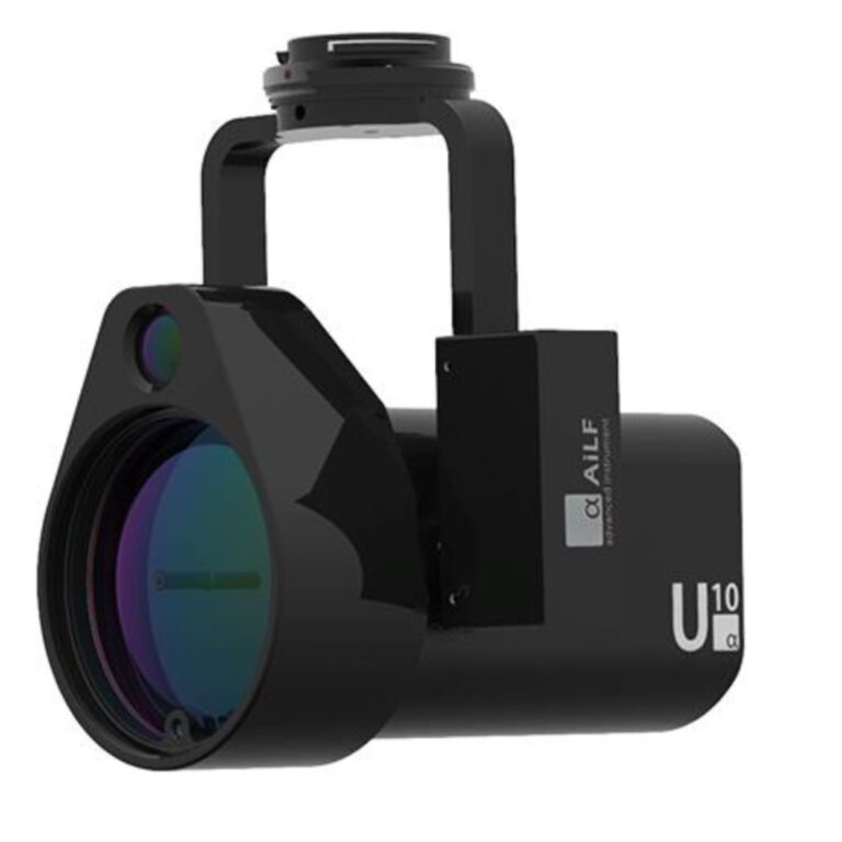
AILF U10 Sensor for Gas Detection
According to Ryan Shelswell, Technical Manager here at Coptrz and with a wealth of gas detection experience, these advances open up some interesting new capabilities. “The advances in technology we are seeing with these two new products show how dedicated detectors for drones can provide a capability to commercial drone operators which had not been readily available before. The range of gases detected, and the sensitivity and specificity of the detection capability, is placing high-quality detectors on drones and integrating the data directly with the already strong survey capabilities of established drone platforms.”

FLIR MUVE 360
There are some obvious use case examples, including those working on gas plants (or gas-powered plants) and pipelines, or other sites that require gas storage of all shapes and sizes. Considering the range of gases used in industrial and commercial applications there will be plenty more companies operating with at least one variant, if not several. Not only could a leak prove a very serious health hazard, but it can also be very costly, with thousands of pounds literally vanishing into thin air.

Road Traffic Collision – Using drones for gas detection
An aerial solution can also be of great benefit to emergency responders or firefighters, who might want an immediate overview of an incident, be it a warehouse fire or a chemical spill. These are all places where you wouldn’t happily want to place a human being due to the potential risks of inhalation and even of an explosion – and so having an aerial ally who can give you a quick and real-time evaluation of any gas detection scenario before you send in a ground team can make a huge difference.
How Drones Can Improve Safety and Efficacy
Removing the human factor from any potentially dangerous situation is obviously a major plus. Being able to remain anywhere from 100 metres to several miles away significantly reduces any risk to those involved. Traditional methods might include a person being kitted up in a large, hot and heavy suit, typically equipped with a limited air tank, who’ll use a handheld sensor that requires them to get very close to the source (and often that sensor will be designed specifically to detect just one type of gas). Using a UAV solution, in the same time it takes to dig out the suit, you could be airborne and seeing the results beamed live to your screen.

Flir Muve Screen
It’s also worth bearing in mind that many gases are lighter than air, meaning that in an indoor environment the gas will rise and be thicker nearer the ceiling. This could mean that a ground-based crew is not getting the most accurate of results, while a drone can cover every corner without the need for scaffolding, cherry pickers or other support – and all while maintaining 360-degree awareness of its surroundings. Indeed, as with inspections and surveying, having a tool that can easily navigate in and around dangerous or otherwise inaccessible places is always one of the main benefits of any aerial solution.
Obviously you can also double up and utilise a gas sensor alongside a visual or perhaps a thermal camera to further increase the amount of data being collected (possibly even a LIDAR solution) – so if you’re checking a power plant or navigating a disaster zone, why not add a 3D map or a 360-degree panoramic to your workflow? With an automated system you can also integrate flights plans and use waypoints to pre-plan or recreate flights, so you can easily track and compare your data over a period of time with inch-perfect accuracy. In an environmental capacity, being able to prove that you’re reducing gas emissions can be a real asset to any business for a variety of reasons.

Flir Muve C360
As Ryan explains: “For periodic testing of identified critical points on an industrial site, these sampling activities previously done with a person and multiple detectors can be automated with a pre-programmed drone, saving time and effort, with the records of the inspection being automatically stored in a rich format.” He adds that, “with suitable calibration and planning these pre-set inspection flights with integrated gas detection provide a significant multi-point inspection capability without expensive infrastructure or labour intensive schedules.”
FLIR Muve C360
Perhaps the biggest of the new announcements, thermal expert FLIR is continuing to expand its operations beyond just the temperature spectrum, with the MUVE C360. Designed for use with the DJI Matrice 210 (V1 and V2), it’s the first fully-integrated multi-gas detector on the UAV market. Primarily designed with emergency services in mind, the multi-sensor system will be able to “provide real-time continuous monitoring of chemical hazards while on the move.”

Flir Muve C360
One major selling point of the system is that while many detection devices will only be able to locate one specific gas, the MUVE C360 has an 8-channel sensor that includes a Photoionization Detector (PID) and a Lower Explosive Limit (LEL) detector. It is also capable of detecting the combustible gases carbon monoxide, chlorine, oxygen, nitrogen dioxide, hydrogen sulphide and sulphur dioxide.
So while a ground team might enter a room looking for one specific gas, a system such as the MUVE C360 might also be able to identify something that they’re missing – which can be crucial for the likes of first responders who can’t predict what situation they’ll be faced with from one day to the next. After all, no-one wants to bring a carbon monoxide detector to a sulphur dioxide fight. According to Alex, “allowing multi-gas detection with sensitivity from parts per million up to %, from an actively pumped sampling system fitted into a dedicated module and interfacing all this with the DJI control and monitoring platform will provide easy to interpret live results.

Flir Muve Pilot and Controller
“For emergency first responders who are not familiar with the sites they visit, the ability to launch a multi-detection capable drone quickly and safely allows for quick assessment and survey of the site with gas analysis, video and thermal imaging creating a better picture before any people enter potentially hazardous areas. This allows teams to reduce the time to respond by allowing a level of surveying without having to don extensive PPE and progress slowly over badly disturbed sites such as collapsed or damaged buildings. The on-screen integration of the chemical analysis data with the images on screen allows for quick changes to be noted and located very accurately on sites.”
It can produce readings based on an alarm system, so if you want to made aware when a certain gas is at a potentially dangerous level, it will let prioritise its findings and display everything in real-time for you to monitor. The company calls it a “time-saving, game-changer for emergency responders, industrial safety officers and environmental monitoring experts” and it’s hard to disagree – although we’d imagine the range of potential use case scenarios can extend even wider in the months and years ahead.
“First responders are constantly seeking better and safer ways to do their jobs, and from the moment the FLIR MUVE C360 arrives in the market, the chemical and gas monitoring process will change forever.”
Jeff Frank, Senior Vice President, FLIR
AILF U10
Designed by DJI partner company AILF Instruments, the U10 is a “UAV-based methane leakage detector”. It’s compatible across the M200 Series (V1 and V2) and, as you might have guessed, it’s designed for the detection of methane, so it should light up like a Christmas tree when you fly over a cattle farm! Such is its abundance on the planet (it also the biggest component of natural gas) methane is an attractive fuel source but it can be difficult to store, while natural build-ups at places such as landfill sites or in underground mines can also have very serious ramifications.
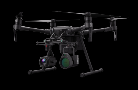
AILF U10 Gas Detection Sensor
With the U10, DJI is targeting gas plants, pipelines and storage sites as its primary markets, but with a wide range of applications for methane across many industrial and commercial businesses, as well as the aforementioned natural occurrences that may need to be monitored, its scope is quite varied.
“The U10 detector brings a lightweight complex detector with the capability for highly sensitive detection to a platform which allows access to places and from directions not easily reached otherwise,” Ryan explains. “The tunable laser diode and absorption measurement system allows detection up to 100m from the drone. Supporting this with a reference 720p visual camera allows the results to be placed into context immediately. For survey and site maintenance the combination of these capabilities on a common SkyPort mount for the DJI platforms allows many drones to find new capabilities.”
Case Study 1: Methane on Oil Rigs
One recent example of aerial gas detection technology being used, saw UK company FlyLogix supply a drone to monitor methane levels on a BP oil rig out in the North Sea. It was equipped with SeekOps sensors that were originally designed for NASA’s Curiosity Rover expedition to Mars, and was capable of delivering a record-breaking 185km round trip from terra firma in Shetland to BP’s Clair platform.

A FlyLogix drone was used to detect methane off BP rig off Shetland
Upon arrival, the craft flew around the rig for 90 minutes, at a distance of 550 metres, all while live-streaming the data collected from the sensor back to the team. Somewhat ironically BP referred to this unmanned system as a ‘pilot project’ but the company has also tested and installed the technology in other facilities as part of its ongoing commitment to reducing methane emissions (which can be more potent than carbon). Being able to detect and measure leaks – and subsequently respond to them – in a quicker and more efficient manner is only going to be good news for everyone.
Case Study 2: Sulphur in Shipping
Under existing regulations, the sulphur content of a ship’s fuel is limited within emission control areas (ECAs) – with a global reduction planned for the beginning of 2020. This means that current craft sailing through ECAs and all ships into 202 and beyond will need careful monitoring of their emissions to ensure they stay within the law. One such solution has been provided by Coptrz’ own sister company Martek Aviation.

Using an unmanned system equipped with gas analysers, it enables the instant detection of sulphur levels to an accuracy level comfortably within the regulations. With long flights times and extended BVLOS capabilities, it can handle checks with the minimum of fuss and little in the way of additional work for the crew – and ensures the ship remains within the legal limitations at all times!
“With greater accessibility to drone technology than ever before, the purpose-built MUVE C360 will provide response teams with improved situational awareness that can help save lives and
livelihoods.”
Jeff Frank, Senior Vice President, FLIR
Download Our FREE RPC-L1 Guide
Understand everything you need to know about moving towards commercial drone operations with our RPC-L1 guide.
- Understand what RPC-L1 is and who it is for
- Learn how the CAA transition impacts operators and training routes
- Get a clear breakdown of requirements, costs and next steps


Related Posts

How Unmanned Vehicles Are Steering the Future of Tactical Operations
Introduction to Sky-Hero Since its launch in 2013, Sky-Hero has been pioneering a new era in public safety and defence through its innovative tactical unmanned vehicles. Tailored to master the complex challenges of indoor environments, these robotic guardians are reshaping strategies and setting new standards in operational safety. Their products, widely acclaimed and approved by professional first-responder operators around the globe, are […]

Agritech Drones: Vegetation Indices And Aerial Imagery
Agritech Drones: Vegetation Indices And Aerial Imagery Will it be a feast or famine this harvest? Precision farming and Vegetation Indices enable farmers to gain a better understanding of their produce. Drones, as part of an agritech solution, are opening up new possibilities for crop cultivators everywhere. Farm field health maps produced from visual and […]

5 Tips for Adding Value to Your Drone Services
The commercial drone industry is rapidly increasing, and we are already seeing a major uplift in drone use across a number of industries, such as media, agriculture, surveying and construction. It’s a great time to start a commercial drone business, however, like all lucrative industries, the threat of competition will increase year-on-year. Only those businesses […]















