5 minute read
The AEC sectors have been using LiDAR as a method for capturing accurate and insightful data for many years. Yet as LiDAR has more recently become accessible and even mobile, the number of suitable applications has grown massively.
In this blog we’ll explore a few of the emerging applications for LiDAR systems, and examining how payloads such as the DJI Zenmuse L1 are pioneering the growth of LiDAR across industries.
What is LiDAR?
For those not aware, LiDAR (Light Detection and Ranging) is a remote sensing technology that uses rapid laser pulses to map out the surface of the earth. LiDAR is useful when used to create high resolution digital surfaces, terrain and elevation models used for various business applications.
Innovations by leading LiDAR manufacturers like Livox and Velodyne have both lowered the cost and size of LiDAR modules, allowing them to be mounted to drones such as the Matrice 300 RTK.
The Zenmuse L1 is a perfect example of this new breed of smaller drone-based LiDAR payloads, yet it still features a powerful Livox module and a full RGB camera for colourised point cloud data.
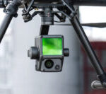
Another consideration is cost, while LiDAR traditionally has been an expensive tool reserved for AEC sectors, these powerful yet lower cost payloads now present a great solution for organisations looking to add LiDAR to their arsenal.
Drone based LiDAR has increasingly become a valuable tool for public safety organisations globally, equipping them with accurate measurement, environmental reconstruction, and real time data capture, providing first responders with previously unused sources of critical insight.
Examples of LiDAR in Public Safety
Accident/ Crime scene reconstruction

With LiDAR you can fly over accident scenes and capture high-resolution 3D evidence for future analysis, bypass roadway congestion and obstructions to quickly arrive on scene and determine next steps.
LiDAR uses ultraviolet- near infrared light to image objects, requiring no external light sources for effective mapping.
For example, when mapping a road accident at night, a LiDAR equipped drone could be easily deployed and make a single pass over the site to gather a detailed arial reconstruction, providing officers on the ground with critical situational awareness.

The speed at which LiDAR can be processed also presents a great advantage, as roads can be opened quicker, freeing up essential workers and reducing the impact on the flow of traffic.
The recorded data can also be analysed later, to better understand the timeline of events and conduct scene analysis on skid marks and vehicle displacement providing a clearer picture to investigators.
Search and Rescue
Drones have been the future of search and rescue for several years, decreasing recue times and allowing emergency workers to find casualties in even the toughest terrains. Payloads such as the DJI H20T are already being used across the UK to provide optical and thermal imagining solutions to aid rescue workers day or night.
Norfolk police find pensioner stuck in marshes
LiDAR sensors are primarily used in the AEC sectors to map surfaces: such as stockpiles, digital twins, and Digital Elevation Models, yet these same applications can also be used to aid search and rescue personnel.

A drone-based LiDAR platform can easily detect casualties in difficult terrains, supporting emergency personnel in their effort to plan and action their recovery. The 3D point cloud map created by the Zenmuse L1 can create a comprehensive overview of the search area, including elevation data, even in areas with dense foliage.
Giving rescue personnel the right insight can make rescue missions safer and quicker, as the mission parameters can be fully understood. In the US national parks alone, over a 1000 Search and Rescue workers are injured ever year on average, suggesting something needs to be done to equip these essential personnel from unknown dangers.
Natural disaster relief
The use of LiDAR in disaster management is increasingly prevalent, as the outputs can provide critical information and aid the relief efforts after a major disaster. As touched upon before, LiDAR payloads can be used to create incredibly accurate point cloud maps to deliver which can be used by emergency services to easily identify the extent of the damage caused by a natural disaster.
For example with increasingly wet winters in the UK, we’re experiencing large amounts of flooding across the UK. LiDAR data sets can use used to map the extent of the flooding across an area, aiding in the disaster relief and future planning again such an event.

Similarly LiDAR has recently been used in the US to preemptively plan against wild fires. Traditionally difficult to track, topographic maps created with LiDAR data has enabled organisations across the US to preemptively understand the directions of wild fires. This has meant that more measures like fire breaks and preemptive burning of brush to be actioned before the dry summer months.
If you’re interest in the commercial uses of drones in Public Safety, make sure to get in contact with our Business Development Manage Sam Denniff to explore potential solutions for your organisation.
Download Our FREE RPC-L1 Guide
Understand everything you need to know about moving towards commercial drone operations with our RPC-L1 guide.
- Understand what RPC-L1 is and who it is for
- Learn how the CAA transition impacts operators and training routes
- Get a clear breakdown of requirements, costs and next steps


Related Posts
Devon & Cornwall Police and Dorset Police Choose COPTRZ as UAV Partner
Lorem ipsum dolor sit amet, consectetur adipiscing elit. In in odio quis nulla aliquet vehicula nec sit.

Consultation on the safe use and effective regulation of drones
The government has today announced they are set to have a consultation on proposed new measures to provide regulation of drones. The ability to provide on-the-spot fines and being able to seize the drone are being discussed in parliament. With the market set to grow at a rapid rate over the next decade, it’s imperative […]

Why Choose COPTRZ For Your CAA PfCO Training
As an approved NQE, COPTRZ provides a complete 4 day CAA PfCO Training Course that enables drone pilots to obtain their permission for commercial operations. Training for all ability levels Our students range from photographers/videographers all the way through to police forces and large corporations looking to use drones as part of their operations. Why choose COPTRZ […]















