Precision agriculture means using technology to optimise farming whilst saving resources. For almond orchards, that means optimising yields.
Many people around the world like to grow the food they love – be it strawberries on a windowsill or an apple tree in a garden. If you’re a fan of almonds, you have to wait quite a long time to benefit from planting an almond tree. It takes almost 7 years before an almond tree will start to flower, and after that, it takes another 7 or 8 months before the nuts mature. The yields, however, are delicious, healthy, and popular. Almonds and almond products (such as milk, flour, and oil) are growing in demand and as a result, putting pressure on farms to optimize yields to grow quality nuts.
Precision agriculture technologies are ideal for optimising yields whilst cutting costs. The applications range from spot-spraying treatments in fields to using multispectral imagery to create vegetation indices and spot disease. These techniques are being applied to almond trees to help boost production.
Testing drone mapping for almond trees
AgroPraxes Ag Tech work in specialised agriculture services in Argentina and Spain. Their assignments include caring for the popular wine grape Malbec in addition to nut and fruit orchards and olive groves. These crops are all highly valuable with specialised care required to prepare the plants for harvest.
AgroPraxes partner with specialised agronomic and enologic consultants to enhance their viticulture and nut tree services. The work they provide includes soil and vegetation mapping to optimise yield quality using Pix4Dfields. Recently, they were asked to work on trial plots in an almond tree orchard to see if their methods would optimize the yield.
Project details:
Location: Yecla, Murcia, Spain
User: AgroPraxes
Software used: Pix4Dfields
Hardware used: DJI Mavic 3 Multispectral
Processing hardware: CPU AMD Ryzen 9 5900X, 64GB RAM, GPU 4080
Processing time: 15 minutes
Images captured: 820
GSD: 19.6mm

Experimental farm techniques using drone mapping
AgroPraxes began their work on an experimental farm that is testing new techniques that will optimize almond cultivation and increase sustainability. The aim of the project was to measure a trial plot and study the use of resources in addition to the challenges of working with limited water supplies. AgroPraxes were also asked to assess the irrigation strategy and determine the farm’s carbon footprint.

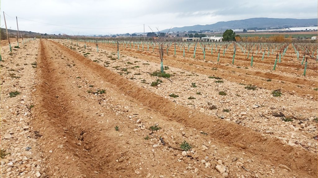
The plot with the almond trees is on a steep slope with a gradient of 6.5%. It is exposed to multiple challenging factors including diverse fauna plagues and changeable weather. During the data collection phase of this project, the AgroPraxes drone pilot had to strategically fly the drone around rain showers and freezing winds.
Using the Magic Tool from Pix4Dfields
The processing of this data was started in the back of the car on the way to the office from the field. The speed of processing meant that the results were ready within minutes. Then, the team started their analysis using the special features built into Pix4Dfields.

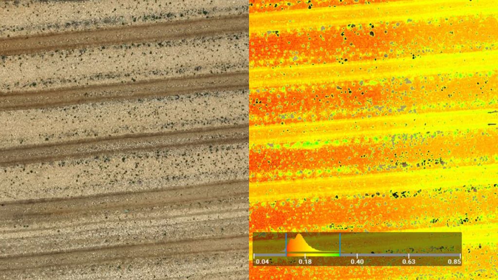
Pix4Dfields’s Magic Tool was launched in November 2022 and is specially designed to help users identify weeds or anomalies in the field in minutes using machine learning, and then plan a spot-spraying application plan. When AgroPraxes processed the data they collected in the field, they used the Magic Tool as part of their analysis.
Thanks to the Magic Tool, the team identified patchy weeds and was able to pinpoint their locations. Of the 1.4 hectare field, only 36% of it had weeds (or 0.55 hectares). The MagicTool recorded this data and it was exported in a format that allowed a spray drone to target the weeds and apply the treatment product only where it was needed, saving money, time, and resources. AgroPraxes used the Agras T10 spray drone to treat the field, which they guided using a shape file from Pix4Dfields’s Magic Tool.
Using the Magic Tool from Pix4Dfields
Sustainable farming practices are relying more and more heavily on precise resource use – rather than blanket spraying a field, it is better to individually treat problem areas or sources of disease. This use of precision agriculture has widespread benefits ranging from reducing waste to preventing chemical flow from reaching neighbouring ecosystems.
“We are working in a busy growing season and reaching the peak of vine care. With the fast processing from Pix4Dfields we are handling a high demand on our services.“
Federico Framarini, AgroPraxes
The speed and precision of this workflow saw AgroPraxes save time and money, and gather data that would be used to better care for the almond trees and thus optimise yields. The team highlighted the speed and precision of the drone mapping software as it gave more insights into the test field – and thus, more information on how best to care for the crop.
Article Credit: Pix4D
Download Our FREE RPC-L1 Guide
Understand everything you need to know about moving towards commercial drone operations with our RPC-L1 guide.
- Understand what RPC-L1 is and who it is for
- Learn how the CAA transition impacts operators and training routes
- Get a clear breakdown of requirements, costs and next steps


Related Posts
DJI Phantom 4 vs DJI Phantom 5
On November 28th, DJI announced the launch of the much-anticipated Phantom 5 drone. Based on the popular Phantom 4 Pro the new model takes the same path as DJI’s most recent launch the Mavic 2 by offering a choice of image sensing equipment. This addresses one of the biggest complaints commercial operators have with the […]

Industry insight on using drones for inspections like the ELIOS 2
In this blog you’ll find out: How to get into the industrial inspection sector using drone technology like the Elios 2 Inspection Drone What drones you can use for industrial inspection A comparison of the ELIOS 2 and the Caged Mavic for inspections An insight into why organisations are keen to adopt technology that reduces […]

NEWS FLASH: Drone has near-miss with commercial flight
The need for Aeroscope was recently brought into the limelight. UK authorities have confirmed that a drone passed a mere 20 feet over an Airbus 319 during takeoff. It’s one of the biggest fears drone pilots have when flying. According to a report released by the UK Airprox Board, a drone came close to an Airbus […]