

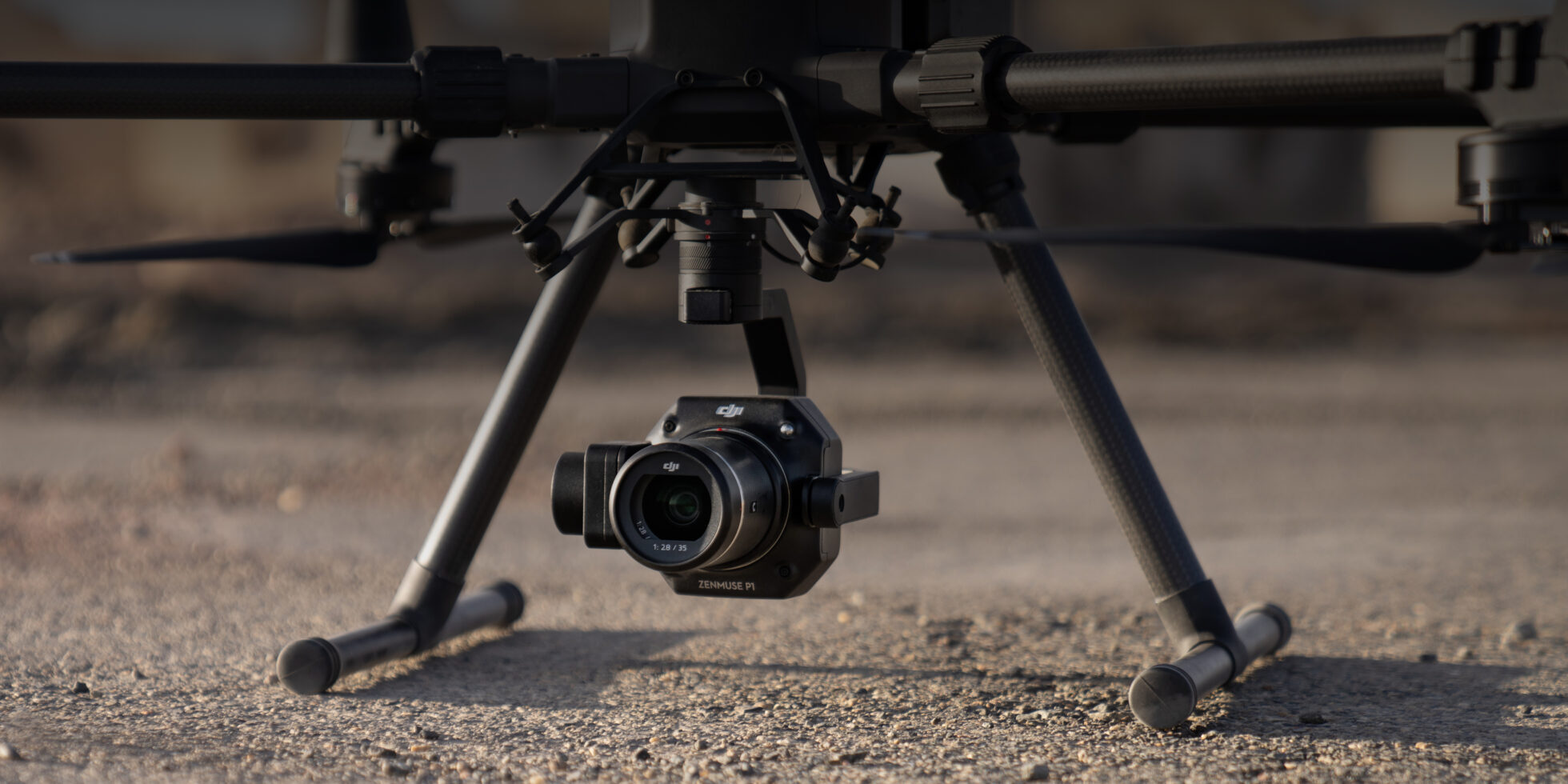
The DJI Zenmuse P1 is DJI’s first entry into the photogrammetry market. Integrating a full-frame sensor with interchangeable fixed-focus lenses on a 3-axis gimbal, this payload takes efficiency and accuracy to a whole new level.
But just how good is this payload?
In this blog, we’ll be answering your questions on the DJI Zenmuse P1.
How efficient is the DJI Zenmuse P1?
For the first time, DJI used a full-frame sensor with a 4.4μm pixel size to give you even higher image quality. With a 45MP sensor and fast shooting intervals, the P1 captures high-resolution images of large areas in short flights, providing you with high-quality meshes that you can share with your clients.
In just four flights totalling 140 minutes, you can expect to collect data for up to 10 kilometres squared of 2D orthomosaics with centimetre level accuracy.
Want to find out how it stacks up against other survey drones? Click here to download our accuracy report!
What quality of images can I get with the DJI Zenmuse P1
The P1 supports various formats, including JPEG, DNG, JPEG+DNG for images or MP4 and MOV for video. This provides you with maximum flexibility for your missions, giving you the opportunity to maximise quality or conserve storage space.

Credit: DJI
With a continuous shooting interval of 0.7 seconds, and a mechanical shutter speed range of 1/2000s – 1s, the P1 provides crisp images without any damage or warping. This means that while the drone travels at a fast velocity, you can still expect the accuracy of data retrieved to meet the requirement of one to five hundred cadastral surveys.
DJI has also included a low-noise and high-sensitivity mode of the P1 that can improve camera sensitivity (ISO) while reducing noise levels, expanding the range of operable scenarios for the P1.
Which lenses does the DJI Zenmuse P1 support?
DJI have created three lenses to accompany the P1, including 24mm, 35mm and 50mm focal lengths that are connected via DL mount. This provides flexibility for missions, giving you the ultimate choice of how far or close to fly to the site. Each lens works within the operational tilt range of the P1, which is -45° to -90°.
The ground sampling distances of each lens are follows:
24mm lens: GSD=H/55;
35mm lens: GSD=H/80;
50mm lens: GSD=H/114;
Ground Sampling Distance GSD is measured in centimetres (cm)/pixel; target distance H is measured in meters (m).
What operating modes does the Zenmuse P1 support when used with the Matrice 300 RTK?
The P1 supports the following operating modes: aerial photography (including Smart Oblique Capture), oblique photography, corridor mapping flight, waypoint flight, and manual operation.
How does Smart Oblique photography work?
One of the most proven techniques for 3D modelling is oblique photography. This is where several lenses are mounted together in an array with fixed axis angles, which allows the camera the ability to capture images that may have been missed by traditional vertical photographs.

The systems use a mechanical rig with five cameras set in positions in a cross configuration; one camera in the centre is surrounded by four other cameras, in front, behind, left, and right, equally distanced at 90-degree intervals. This arrangement places the central camera at an oblique angle where the ‘nadir angle’ (an angle measurement used by aircraft which uses the downward vertical as zero) is a known, fixed point in the images collected.
With the Zenmuse P1, DJI has released a feature called ‘Smart oblique photography’, whereby photo ortho and oblique photos necessary for 3D reconstruction are acquired through one flight path. Only photographs that are essential to reconstruction are taken at the edge of the area of flight, reducing the images collected and drastically improving the efficiency of post-flight processing.
With each flight area requiring a unique capture strategy, photos taken on each flight path are based on the target data collection zones set by the user. The aircraft will then fly in the most efficient mode, with flight speed being adjusted based on the different oblique capture sequences in each sector.
On occasions, only four, three or maybe one angles will be captured by the Zenmuse P1 when flying in Smart Oblique Capture mode. Generally, this will happen at the edge of a flight area and happens because the P1 is designed to capture images that are required for the 3D model. The shooting sequence executed depends on the size of the measurement area demarcated by the user, the flight altitude, and the camera’s tilt angle.
Want to find out more on Oblique Mapping? Click here to find out how to use it within DJI Pilot on your Matrice 300 RTK

What surveying and mapping scenarios can the Zenmuse P1 be used?
The P1 is an incredibly flexible solution, offering services for 2D orthomosaic, 3D obliques, live-mapping and detailing modelling.
Application scenarios include:
- Topographic Mapping – A detailed record of a land area, giving geographic positions and elevations for both natural and man-made features.
- Cadastral Surveying – A specialised survey for the establishment and re-establishment of real property boundaries
- Architecture, engineering, construction, and Surveying
- Natural Resource Management – The management and classification of natural resources, such as land, water, vegetation etc.
- Geological Investigation – Understanding the structure and layout of the land
- Disaster Site Modelling – Obtaining real-time overviews of disaster-struck areas that can be relayed to teams on the ground to better enhance decision making.
Does the DJI Matrice 300 RTK support PPK post-processing when used with the Zenmuse P1?
It does. The task folder on the stores photos, original global navigation satellite system (GNSS) observations, and TimeStamps.MRK files, which. Are used for PPK post-processing calculations.

Post Processed Kinematic (PPK) is a GPS correction technology technique that corrects location data after it is collected and uploaded. The data can be uploaded to the cloud for processing or processed using specialised software on your desktop after the flight has been concluded.
Alternatively, you could also use RTK (Real-Time Kinematic) sim-card to provide real-time corrections to location data as the drone is surveying and capturing images from a site.
Not sure if you need a PPK station? Find out what is better for you with our PPK vs RTK blog!
Find out more information
Want to get more information on the DJI Zenmuse P1?
Not sure if it’s right for your needs?
Get in contact with us today. We have a team of dedicated experts waiting to help you with your onboarding and upscaling of drone technology. Whether you’re just beginning your drone journey, or you’re looking to expand an existing drone team our team is ready to help you every step of the way.
Simply fill out the form below and we’ll be in contact as soon as possible.
Download Our FREE RPC-L1 Guide
Understand everything you need to know about moving towards commercial drone operations with our RPC-L1 guide.
- Understand what RPC-L1 is and who it is for
- Learn how the CAA transition impacts operators and training routes
- Get a clear breakdown of requirements, costs and next steps


Related Posts

Top 5 Multispectral Drones in 2026
Multispectral drones have surged in popularity as businesses and researchers uncover the vast potential of data collection offered by these cameras, capturing invaluable details that are invisible to the naked eye. These advanced systems capture data across multiple light spectrums, unveiling details of in water and on land that can’t be seen with the naked […]

Army Veteran Stu Logan’s Journey: Launching a Successful Drone Business
Stu Logan makes up one-half of Unmanned Air Veterans along with his business partner Tom Hubbard who met each other while serving in the British military. After being introduced to drones very early on when he was assigned the role of drone pilot, Stu says he hasn’t looked back since! But it hasn’t all been […]

The Pathfinder Program: Drones And Nuclear Power
UK Drones Pathfinders Programme announces new pathfinder focused on detecting marine activity near nuclear power stations On 22nd July 2020, the UK Drones Pathfinder Programme announced that they would be adding a new pathfinder programme project which focussed on detecting marine activity at an early stage, particularly when the activity is near nuclear power stations. […]


