What is LIDAR?
It’s a common question for those new to the more technological side of surveying operations, including the use of drones for aerial mapping and inspections. The short answer is that it’s much like radar and sonar for detecting the location of objects, only it fires out a laser. A slightly longer one might be that whereas standard photogrammetry is typically using visual RGB images to survey a location (with the camera capturing the light reflecting off surfaces), LiDAR drone capability creates an image using thousands of points of data – and this opens up a wealth of new opportunities for precision LIDAR surveying.

LIDAR point cloud captured by drone
This is not to say that LIDAR is always the preferable solution, as photogrammetry certainly has its place and is typically a lot cheaper to set up than a LIDAR system. However, LIDAR really comes into its own when you’re looking for fast and efficient aerial surveying, not least for its ability to ‘see’ through cloud cover, tree lines, low-light and other factors that might impede traditional photography. In addition, while photogrammetry can happily create an accurate 3D map using multiple overlapping images, LIDAR will create the same map based precisely on the measurements involved, which can then be used to create accurate digital elevation and/or terrain models (DEMs/DTMs).
In many cases, LIDAR can also prove a more precise solution for detailing small or narrow objects, such as powerlines or pipelines, that a visual image might struggle to pick out against its surroundings (not unlike a thermal camera, only using very different data). Photogrammetry can still hold an advantage in other areas when it comes to relative and absolute accuracy but in many circumstances, a LIDAR-equipped solution can prove an invaluable resource.
“Standard photogrammetry uses visual RGB images to survey a location, whereas LIDAR creates an image using thousands of points of data”
LiDAR, LIDAR or lidar?
The technology dates back to the 1960s shortly after the introduction of the laser. Coincidentally, laser is an acronym that is now widely accepted in the English language (and is no longer written as one in capitals), while LIDAR is still open to debate. The name was originally a portmanteau of ‘light’ and ‘radar’ but was then broadened to become an acronym for ‘light detection and ranging’ to more closely match that of its sibling (radar, along with sonar, being another accepted acronym that no longer requires capitals). In summary, all variations of the name are generally acceptable so feel free to stick with whatever you’re comfortable with!
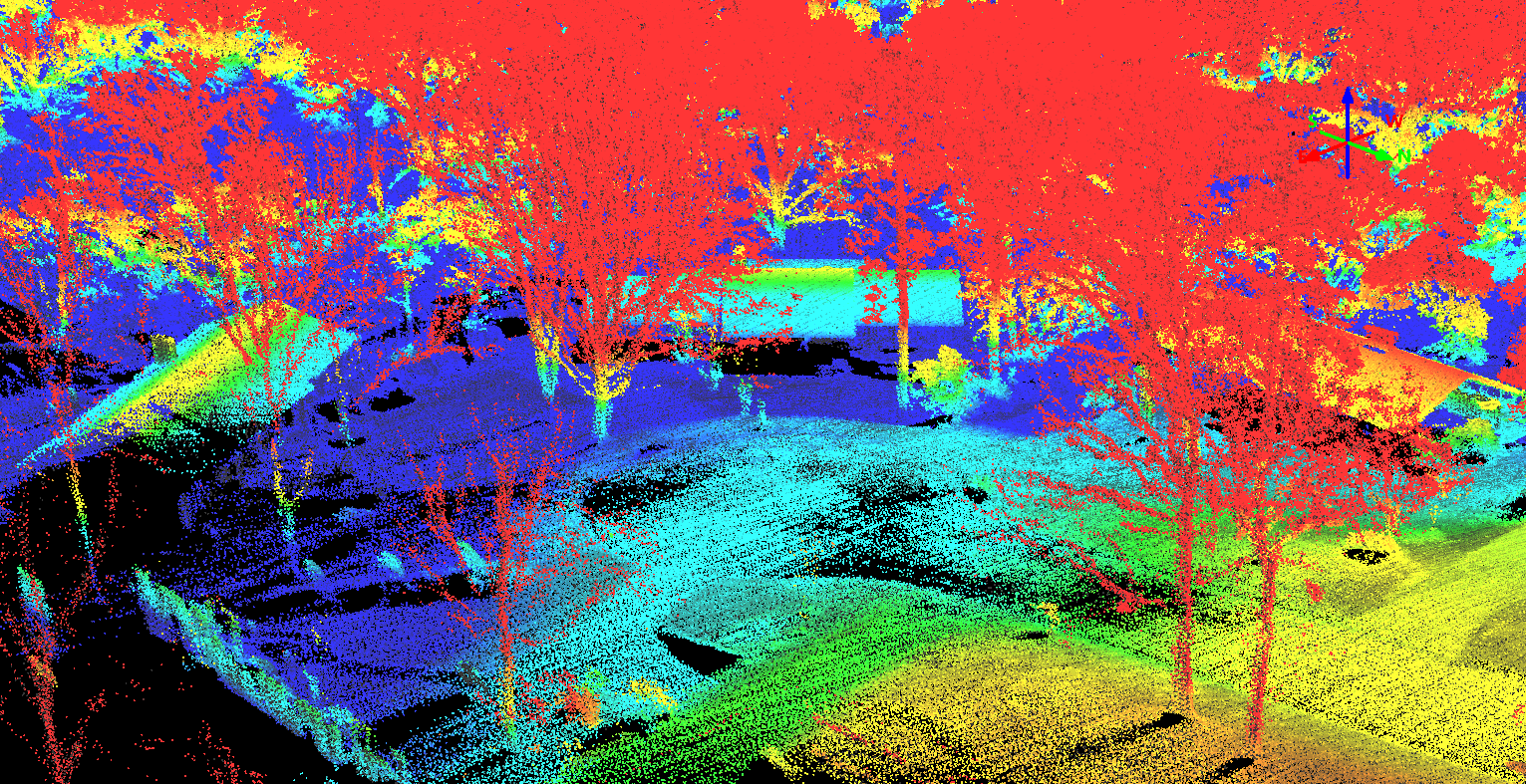
LIDAR point cloud captured by drone
How does LIDAR work?
As mentioned, LIDAR works in much the same way as sonar and radar, only by using a laser that is fired from a sensor or scanner. The laser then bounces back from whatever it hits and the sensor records the time it takes to return – with a simple equation using the time, multiplied by the speed of light (300,000km per second) and divided by two to counter the return journey, used to determine the distance travelled.
This in turn gives an accurate positioning point of where that single laser beam hit; only the sensor is capable of firing out hundreds of thousands of beams in quick succession, which quickly builds up into a detailed ‘visual’ representation of what the sensor is focused on – be it directly below, above or at an oblique angle, while also filtering out any additional reflections or ‘backscattering’ from the laser’s travels. As one relatively simple example, LIDAR technology is used in police speed guns, with several readings of the car’s distance over a very short period enabling the device to calculate its speed.

LIDAR point cloud captured by drone
It is this process of firing the laser multiple times that enables the sensor to see through tree cover and low-lying vegetation; as where one beam hits the edge of a leaf, the next will squeeze through the tiny gap next to it, much like how you see beams of sunlight searing through the trees when you’re standing in a forest.
This enables a LIDAR system to monitor the likes of the Amazon rainforests from above the canopy and other areas that would otherwise require a much closer inspection or possibly even a ground-based solution, with various colour palettes being used to help identify variables within each image – be it based on height or more fine-tuned, and most likely pre-planned, variations such as the type of surface that’s being surveyed (rocks, plants, soil, water, etc.).
|
“The process of firing the laser multiple times enables the sensor to see through topography such as tree cover, foliage and low-lying vegetation”
LIDAR for Surveying
For aerial surveying operations, a LIDAR-equipped drone also needs to incorporate a GPS or GNSS system in order to determine its exact position, along with an inertial measurement unit (IMU) to compensate for the movement of the craft itself (in terms of pitch, roll and yaw as it bobs about in the air). There is also the need for a decent computer to process all the data, possibly with some additional software depending on what you want to do with the information.

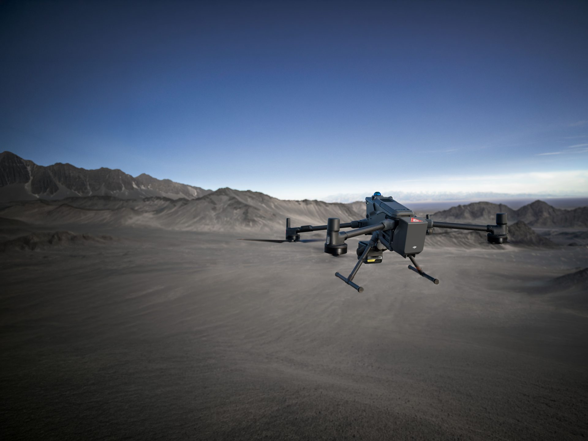
Quadcopter Drone with LIDAR Camera
This can mean that you need to spend a little extra on the craft itself, with the likes of the DJI M600 and M200 Series a popular choice (both compatible with many LIDAR products, including those of our partners at LIDAR USA), while possibly also looking into RTK and PPK solutions and enhanced software that will cost more than a photogrammetry package.
However, one plus point of LIDAR is that it doesn’t require ground control points – although a couple can help to validate your accuracy – whereas a more visual survey will most definitely benefit from the time, effort and expense of setting up a series of GCPs. Also, LIDAR requires less of an overlap of images to create a 3D model – typically around a 20-30% overlap compared to at least double that for a visual orthomosaic – meaning you can conduct operations that much quicker, while the processing time involved will also be a lot shorter as you’re not dealing with numerous high-res RGB files.

Quadcopter Drone with LIDAR Camera
So, as with all drone operations, there are plenty of variations to consider before choosing which option is the best and most cost-efficient for your needs – not to mention the many other variables based on the type of sensor you’re using, along with how you operate the drone itself (high versus low altitude surveying for example).
|
When can LIDAR surveying be used?
There are many areas within aerial surveying and drone inspection operations where LIDAR can prove extremely beneficial. As discussed, there might be plenty of areas where a simple RGB payload might be more than enough to get some great results, but if you can maximise the benefits of a LIDAR system, be it to look into places a visual camera can’t or to work purely with the data associated with a survey rather than the photograph involved.
We’ve mentioned working in forested areas as being one prime example of how the technology has an advantage, and we’ve also recently blogged about how such a system is being used to monitor Scottish woodlands while checking for the spread of fungal-spreading rhododendron bushes, along with the ability to measure tree density and much more. Agriculture is another excellent area, not just because of its ability to see through the vegetation or crops, but it’s also great at checking for drainage (for example, to survey levees on rice farms), monitoring yield rates and identifying areas that might warrant more or less, water, seeding, fertilisation and so on.

GeoAerospace pilots with LIDAR equipped Drone
Similarly LIDAR can be used in landscaping projects, such as monitoring the effects of erosion or deformation over a period of time. It can detect subtle changes in the topography or be used in the event of landslides or natural disasters to deliver a quick overview of the scene and quite possibly get a glimpse below the surface. We’ve also seen these techniques used by archaeologists to document historic buildings and also to identify where long-since disappeared buildings and gardens once stood based on otherwise barely noticeable geographical traits.
As discussed, LIDAR is also great for picking out narrow objects such as pipelines, powerlines and railways, which can be great on their own to check for slack cables and so on, but by mapping the surrounding areas you could also check for overhanging trees that might warrant trimming before they become an issue and other hazards.
“LIDAR can detect subtle changes in the topography or be used in the event of landslides or natural disasters to deliver a quick overview of the scene”
|
How is LIDAR surveying impacting different industries?
There are plenty of other engineering applications covering all aspects of infrastructure and maintenance, and you can also find LIDAR being used to manage road networks – mapping all the key details down to the road signs and surrounding location, as well as monitoring traffic flow and more. It’s also been used after road accidents at night, ensuring a detailed collation of the required evidence can take place in darkness and enabling the road to be re-opened before the morning rush (and potentially saving millions as a result, with a major road estimated to cost up to £1m per hour while it’s closed).
LIDAR is also being used on construction sites and mining, where large scale mapping in potentially dangerous or inhospitable conditions is required, or for detailed volumetrics where the many precise measurements can be used to give an accurate calculation for the amount of materials piled up or being moved around. LIDAR has also been used in mines to check for safety after explosives have been used, mapping the newly opened tunnels without putting humans at risk and even doubling up as a collision avoidance tool as the drone can tell how far you it is from the walls, even in total darkness!

Quadcopter Drone with LIDAR Camera
These are just a handful of examples where LIDAR can make a big difference and there are plenty more we could mention. As we’ve said, in many of these situations a standard photogrammetry set-up could prove more than enough for your needs, but LIDAR really can offer an entirely new perspective on your surveying work. And if this has piqued your curiousity even just a little then we’d be more than happy for you to get in touch with us to talk more about your options and how they could apply to your own aerial operations!
|
 and COPTRZ
 and COPTRZ
LiDAR USA, produce laser mapping cameras and specialize in LiDAR Solutions, as a partner with LiDAR USA, Coptrz offer specialist LiDAR solutions for all surveying and mapping requirements. James Pick is our dedicated surveying and mapping specialist for UAV operations and has extensive knowledge in using LiDAR for Inspection Applications as he is a surveyor by trade.
 “We have helped organisations such as Costain, Jacobs Engineering & J Murphy & Sons revolutionise the way they acquire survey data by introducing aerial LIDAR systems to the business. Using LIDAR to acquire survey-grade data is 80% faster, safer and much cheaper than conventional methods. This is improving their profitability, increasing their market share and threatening the existence of technology shy competitors.”
If you would like James to call you to arrange a demonstration of the LiDAR camera in action then get in touch with COPTRZ today. Alternatively, if you’d like to know more about LIDAR then watch one of Jame’s VLOG episodes on LIDAR below on our COPTRZ Youtube Channel.
Free Whitepaper Report:

How LIDAR is revolutionising mapping and geospatial data
Drones equipped with LIDAR cameras are revolutionising the way we gather data, making operations faster, safer and more cost-effective. Whether you’re documenting a road accident scene at night, designing rice field irrigation systems or surveying archaeological sites under dense forest canopies, advances in 3D mapping and geospatial data capturing are making these once time-consuming tasks, quicker and more efficient than ever before.
Download Report Here
Explore our LiDAR survey training course to build a complete understanding of LiDAR workflows and applications. Contact the Coptrz team at sales@coptrz.com or on 0330 111 7177.
Download Our FREE RPC-L1 Guide
Understand everything you need to know about moving towards commercial drone operations with our RPC-L1 guide.
- Understand what RPC-L1 is and who it is for
- Learn how the CAA transition impacts operators and training routes
- Get a clear breakdown of requirements, costs and next steps


Related Posts

Why You Should Take The Commercial UAV Surveying Course
Why You Should Take The Commercial UAV Surveying Course The drone industry is a growing business. According to a recent RICS study, the list of approved commercial operators using drones in the UK jumped from 359 to 5,000 between 2014 – 2019. With this growth, various businesses have seen innovations, especially within the surveying industry. […]
Emesent GX1: The World’s Most Accurate RTK SLAM Mobile LiDAR Scanner
When your project demands both speed and accuracy, compromise is no longer acceptable. The Emesent GX1 is redefining mobile mapping by combining RTK precision, advanced SLAM technology, integrated 360° imaging and flexible deployment options in one powerful device. If you are looking for a high-accuracy mobile LiDAR scanner that delivers reliable global positioning, repeatable results […]

Flyability Elios inspects Barcelona’s Sewer System
Aigües de Barcelona, Empresa Metropolitana de Gestió del Cicle Integral de l’Aigua, S.A., is the company responsible for a vast sewer infrastructure below the city of Barcelona and environs. Owned by global water and waste experts Suez, the company makes environmental issues a priority: responding with the best tools available. Péter Kövessi is the Director […]